


 Country:

 City:
City:


Head to La Roche-des-Arnauds via the D994, then follow signs for the village centre. Continue along the D418, following the signs for “Les Roux – Les Baux” for just under 2 km. At the large hairpin bend, turn left onto the Route Forestière de Matacharre (a dirt track but passable by cars), which climbs gently north-westwards. Pass the junction leading to the hamlet of Les Revioures, and continue along the track opposite until you reach the junction of the Conode track and the track to the Matacharre Forest House (marked by a water tank).
Alternatively, you can leave your car parked on the right-hand side of the road, in the large hairpin bend to the right, and walk up the Matacharre Forest Road (RF).
(S/E) Take the track that climbs to the right towards the Col de Conode. After about 2 km, pass an ONF barrier (parking available just before it).
(1) Continue up the track until you reach a clear area with a junction.
(2) Take the track that climbs to the right towards the Col de Garcinel, heading south-east, leaving the Col de Conode track straight ahead. An easy climb leads to the Col de Garcinel.
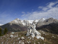
(3) Turn left onto the path leading uphill (cairn), heading north-east. Leave the track and follow this path as it winds along the Crête de la Clappe. Stay firmly on the ridge until you spot a large, clearly visible cairn.
(4) Continue along the ridge path opposite, heading north, and ignore the path on the right which cuts across the slope towards the Col des Roux. Climb to the summit of La Clappe, marked by three large cairns. Be careful – you may need to use your hands on some rocky sections.
(5) Follow the ridge path down towards the Col des Roux, heading east. Continue for less than a kilometre, staying on the ridge as far as possible, until you reach the path junction at the edge of the forest.
(6) Turn right onto the hillside path, heading west. This “Crête de Clappe to Col de Cabrette” path passes beneath the Tête de la Clappe.
(4) Carry on to the left as far as the Col de Garcinel (3) and take the track on the right to descend due north to the Route Forestière du Col de Conode (elevation 1624).
(2) Take the forest road that descends to the left, ignoring the one leading up to the Col de Conode, to reach the junction with the Matacharre track (S/E).
 Visorando Member
 Very difficult
 Easy
Easy 
