Country:

 City:
City:


Get to La Roche-des-Arnauds via the D994. Park in the car park at the cemetery or the town hall.
(S/E) Walk up the embankment alongside the Épervier stream (or take the Chemin des Aires and negotiate the right-hand bend), then follow the Chemin du Colombier to the stone bridge and a signpost (533).
(1) Take the path that climbs up the right bank of the stream, towards Serre La Gerle. The yellow PR® route is the Circuit de la Gerle. Be careful: depending on the season, the signpost may be obscured by vegetation.
After 200 m, the path leaves the riverbank and the slope becomes steeper. The path runs alongside a field, then joins a track which you follow uphill to the left until you reach the hairpin bend.
(2) Leave the track and take the small path opposite (yellow markings on the tree). Be careful: there are a few steep and overhanging sections.
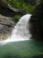
The route offers several views of La Gerle waterfall and its pools.
The path then runs along the edge of a field until it reaches a track.
(3) Take the track on the right, before passing the Béal de Pré le Bayle. Stay alert as the markings on this section of the “Tour de La Gerle” trail are sparse. You’ll reach a junction.
(4) Head up to the left, heading north-east, towards “Le Peyssier” and “Les Baux”. Continue straight on past Serre la Pigne, still heading north-east, to pass beneath the “L’Épervier” reservoir and reach the hamlet of Les Baux (with itsdistinctive rooftops).
(5) Follow the signposted path along the Route des Baux (take care) to the hamlet of Les Bas Baux and take the path on the right.
(6) Take the path leading down to the right, heading south-east, towards La Distillerie, and leave the main track, which you will cross again 200 metres further on. Walk down to the next junction.
(7) Continue along the path straight ahead, heading north-east towards Rabou, ignoring the path leading down to the right towards La Distillerie (Correo). Be careful: the path has collapsed in places, but a few cairns help you find your way. Reach the Petit Buëch and cross it via the footbridge (its condition may vary). Reach a junction.
(8) Turn left to follow the Petit Buëch northwards, leaving the marked path. Be careful: the path runs along the stream bed and may become impassable when the water level is high (the path is submerged with a strong current , even at the edges). You’ll catch sight of the village church of Rabou perched on its rocky outcrop.
(9) Turn left to cross the La Rivière stream, heading north, then cross it again before taking a short round trip to the Rabou waterfall.
(10) Continue left, heading south-east, to climb up a large scree slope and then descend through the trees. Reach a junction.
(11) Turn left, heading south, then climb a fairly steep path before joining a more pleasant track through the forest.
(12) Turn left, heading north-west, to descend towards La Rivière and its small waterfalls.
(13) Retrace your steps to head back up to the pleasant path.
(12) Carry on straight ahead uphill until, at a bend, you join the small road (D503) leading to Rabou.
(14) Carefully walk up the D503 on the right for about 500 metres.
(15) Take a path on the left (unmarked) for a few metres, then turn immediately right. The path runs alongside and then joins the road.
(16) Carefully walk up the D503 road on the right for about 200 m.
(17) Take a narrow track that descends to the left into a small valley. Pass an abandoned wreck of a car by the side of the track.
(18) Take the signposted path opposite, heading west towards Roche-des-Arnauds. Walk through the forest before reaching the banks of the Petit Buëch and crossing it via a footbridge.
(19) Turn left, heading south-west, to follow the PR® signposted path towards La Roche.
(20) Take the path on the left and leave the track to follow an old canal.
(21) Head down to the left and leave the PR®-marked trail to take a small path running alongside a field. Reach the Petit Buëch and then pass below the village. Wade across the Épervier torrent (which can be tricky after heavy rain) and reach a junction.
(22) Turn right, heading north-east, and take the Chemin de La Digue, which overlooks the Épervier, to reach the Montée du Pont; turn left here to return to the car park (S/E).
 Visorando Member
 Easy
Easy 

 Very difficult