Country:

 City:
City:


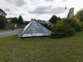
Park at the Pyramide car park on Rue Carnot.
(S/E) With your back to the Pyramide, head towards Rue Carnot and walk down it towards the town hall. Cross Rue de Carency at the pedestrian crossing, which is set back to the left, and continue to Place de Kensington.
(1) Cross at the protected crossing towards Rue Pierre Curie, which you take on the right. At the bend near No. 8, take the path on the right and join Rue Émile Verdière. Follow this road and, at the end, turn left onto Rue Voltaire. At the Stop sign, turn right onto Rue Jean Jaurès and go under the motorway bridge.
(2) Turn right onto Chemin d’Angres, then carry on straight ahead through the left-hand bend. Further on, turn left at a 90° angle to join Rue des Normands and carry on straight ahead. At No. 32, take the path on the right until you reach the gate on your right; go through it and enter the woods.
(3) Further on, take the path on the left and follow it to the end to come out onto Rue Dégréaux. Turn slightly left, then cross the road a few metres further on with great care as there is no pedestrian crossing at this point. Enter the woods.
(4) At the crossroads, head straight ahead.
(5) Further on, go through the gate; do not head towards Pinchonvalles but turn left immediately and go through another gate. Walk down carefully as the path is quite slippery in wet weather. Continue until you reach the edge of the woods and come out onto Rue Frédéric Kuhlman. Walk along the housing estate on your left.
(6) Turn left and carry on to the four-way junction you passed on the way there.
(4) Head straight ahead. At the junction, keep right and carry on straight ahead to come out onto Rue du Bois Malo. Walk for about fifty metres.
(7) Turn right into Impasse Léon Degreaux. At the Stop sign, cross the road and go through the gate opposite. You’ll arrive at the site of the former Liévin Pit No. 6.
(8) Turn left. Continue along the wooden walkway and up a few steps; at the end of this path, turn left again. Go through the gate to reach Rue Victor Hugo in Givenchy-en-Gohelle. Turn left into Rue Montesquieu, then, at the Stop sign, turn right into Rue Marcel Sembat.
(9) Turn right again onto Rue Pasteur. Go straight on and continue along the path until you reach the “The Pimple” monument, where you should turn right.
(10) Take the sharp left-hand bend and follow the road alongside the motorway.
(11) Turn right, go under the bridge and head downhill.
(12) At the right-hand bend, take the path on the left. Go through the barrier, cross Rue Victor Hugo and head up Rue du 8 mai 1945 on the opposite side until you reach the ‘Stop’ sign on Rue Carnot.
Cross the road at the pedestrian crossing and return to the Pyramide car park (S/E).


 Association / Club / Walk leader

 Easy
Easy 
 Visorando Member