


 Country:

 City:
City:


Park in the small car park below the restaurant, alongside the stream.
(S/E) Take the narrow lane that climbs steeply to the left of the restaurant. This lane turns into a fairly steep path and ends at a junction.
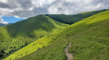
(1) At the junction, turn left and follow the path as it climbs. Before it bends to the right, leave the path and head straight up the slope, out of the forest and up the mountainside until you find a path running along the mountainside.
(2) Continue left along this path running along the mountainside, pass through a gate for cows, then carry on along the same path until you reach a junction. On the way, ignore a path leading up from Garin.
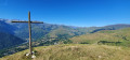
(3) Turn right and climb up to the Croix de Garin, following the narrow path. The slope is quite steep and the climb is arduous.
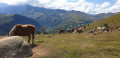
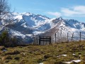
(4) Magnificent panoramic views of the 3,000-metre peaks of the Luchonnais. Continue along the path which runs alongside two tree plantations.
(5) Leave the path by turning right onto a narrow track that runs alongside a fence on the left, leading to a group of cromlechs (Sarrat de Cousseillot on the map).
(6) At the cromlechs, take a wooden walkway to cross over the fence and reach the field. Follow the path that branches off to the right, climbing a small hillside. The path winds along the mountainside.
(7) Turn left onto a fairly steep (and barely visible) track that descends towards the trees. You will then join a wide path further down.
(8) This path takes you back to the junction from the outward journey.
(1) Turn left and head down the same route you took on the way out until you reach the car park at Billière (S/E).



 Visorando Member
 Easy
Easy 
 Difficult
