L’Adret de la Lionne – Dieulefit-Bourdeaux region

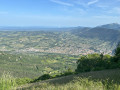
This challenging route, exceptional for its elevation gain and technical trails, will take you from the lavender fields of Teyssières to the summit of Cougoir, at 1,220 metres. The 360° panorama will allow you to enjoy a sweeping view of the Pays de Dieulefit and the valleys of the Drôme Provençale.

Details

n°1214128
Creation:
Last update:
Last review:
  • Mountain biking
    Activity: Mountain biking
  • ↔
    Distance: 11.01 mi
  • ◔
    Duration according to the author: 4 hrs 
  • ▲
    Difficulty: Very difficult

  • ⚐
    Back to start: Yes
  • ↗
    Ascent: + 2,805 ft
  • ↘
    Descent: - 2,825 ft

  • ▲
    Highest point: 3,990 ft
  • ▼
    Lowest point: 2,005 ft
  • ⚐ Country: France
  • ⚐
  • ⚐ City: Teyssières (26220)
  • ⚑
    Start/End: N 44.45319° / E 5.154607°
  • ❏
    IGN map(s): Ref. 3139OT

  • ◶
    Type of surface:
  •  
     
     
    ■ 33% Road ■ 34% Byway ■ 33% Path
  • ⇧
    Bike carrying: Not specified
  • ▲
    Difficulty: Not specified
  • Hour-by-hour weather

Description of the route

Start from the Auberge de Miélandre in Teyssières.

Mountain bike route no. 11.

(S/E) From the Auberge de Miélandre, head down the D130: watch out for cars! At the bend, take the path straight ahead.

(1) At Pied Pourtier, follow the track opposite. Join the road at Teyssières Vieux Village.

(2) Take the road on the left; 100 metres further on, cross the ford on the right; the track runs alongside the River Lez.

(3) At Les Favières, turn left; there’s a steep climb to reach the Col de Lachaud.

(4) Follow the track, which climbs slightly before descending towards Les Audries.

(5) Head up to the left to reach the Col de la Pause.

(6) Walk along the left-hand side of the field, then take the well-marked path that crosses the meadow heading south, passing through a gate (please close it behind you!).

(7) At Petit Herme, continue to the right, slightly uphill, then take the technical descent to the Col de Venterol.

(8) Head up to the left along the path which leads onto a lovely track climbing towards the summit, passing through La Pousterle (alt. 970m). At the end of the track, there’s a short carry to the summit.

(9) Descend via the single track which passes through Montagne la Croix (alt. 1180m).

(7) Turn right at Petit Herme and continue to Col La Pause.

(6) Turn right, passing through an old gate. 100m further on, at the boundary marker, follow theGRP® (yellow and red markings) to the right; this is a very technical descent. Caution: hikers may be present.

(10) At L’Adret de la Lionne, take a poorly marked path to the right; there are some very technical sections during the descent.

(11) At Les Pignes, head down a lovely track to the right.

(1) Return to Pied Pourtier and turn right onto the path taken on the way up (S/E).

Waypoints

  1. S/E : mi 0 - alt. 2,034 ft - Auberge de Miélandre
  2. 1 : mi 1.09 - alt. 2,106 ft - Crossroads of the circular loop
  3. 2 : mi 1.32 - alt. 2,113 ft - Teyssières signpost, Old Village
  4. 3 : mi 1.86 - alt. 2,251 ft - Favières signpost
  5. 4 : mi 2.67 - alt. 3,051 ft - Signpost - Col de Lachaud (927m)
  6. 5 : mi 3.33 - alt. 2,795 ft - Les Audries signpost
  7. 6 : mi 3.92 - alt. 3,225 ft - Signpost > - Col de la Pause (988m)
  8. 7 : mi 4.12 - alt. 3,320 ft - Petit Herme signpost
  9. 8 : mi 4.78 - alt. 2,861 ft - Signpost > - Col de Venterol (865m)
  10. 9 : mi 7.01 - alt. 3,990 ft - Summit
  11. 10 : mi 8.54 - alt. 2,976 ft - L'Adret de la Lionne signpost
  12. 11 : mi 9.57 - alt. 2,300 ft - Pignes signpost
  13. S/E : mi 11.01 - alt. 2,034 ft - Auberge de Miélandre

Notes

We strongly recommend that you take the IGN map referred to on these pages with you. Mountain bikers must be self-sufficient; professional guides are available if required. Emergency number: 18 or 112.
Enquiries at the Dieulefit-Bourdeaux Tourist Office
Tel: 04 75 46 42 49
Email: ot@dieulefit-tourisme.com

Reviews and comments

5 / 5
Based on 1 review

Reliability of the description
5 / 5
Ease of following the route
5 / 5
Route interest
5 / 5
Bally26
Bally26

Overall rating : 5 / 5

Date of your route : Feb 21, 2024
Reliability of the description : ★★★★★ Very good
Ease of following the route : ★★★★★ Very good
Route interest : ★★★★★ Very good
Very busy route : No

It’s certainly a challenging walk, as there’s quite a bit of elevation gain, but it’s also very scenic, with magnificent panoramic views to enjoy along the way

Machine-translated

Other walks in the area

For more walks, use our search engine .

The GPS track and description are the property of this route's author. Please do not copy them without permission.