Wangenbourg Engenthal - Urmatt

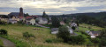
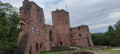
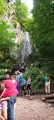
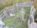
From the ‘Little Switzerland’ of Alsace to the Bruche Valley, this seventh stage of the journey through the Vosges, presented by Passion Vosges magazine published by DNA and L’Alsace, takes you through the wild heights of the Schneeberg and introduces you to the castles and the Nideck Waterfall between Wangenbourg-Engenthal and Urmatt. A stage narrated by Romain Gascon. The entire route follows the Red Rectangle, unless otherwise stated.

Details

70102787
Creation:
Last update:
Last review:
  • Walking
    Activity: Walking
  • ↔
    Distance: 11.13 mi
  • ◔
    Average duration: 6h 35 
  • ▲
    Difficulty: Difficult

  • ⚐
    Back to start: No
  • ↗
    Ascent: + 1,696 ft
  • ↘
    Descent: - 2,418 ft

  • ▲
    Highest point: 3,002 ft
  • ▼
    Lowest point: 787 ft

Photos

Description of the walk

Starting point: Wangenbourg-Engenthal Town Hall

(S) From Wangenbourg Town Hall, take Rue du Général-de-Gaulle, then turn right onto Impasse de l’Escalier. Cross Rue du Panorama, first turning right then left, and head into the forest, leaving the road behind and turning left, heading south-west, onto the GR®53. Continue to a Fork in the road.

(1) Then turn right onto the GR® uphill and continue straight ahead, uphill, to the Col du Schneeberg.

(2) Take the path leading uphill straight ahead and continue to the first junction towards Lottelfels.

(3) Continue straight on until you reach the refuge.

(4) Keep to the right and continue straight on until you reach and follow a ridge at a junction.

(5) The route veers left. At the track, first turn right then left, then continue straight down the slope until you reach a multi-way junction with a path marked with a Red Triangle.

(6) Follow the path down the slope, then turn left and continue down to the D218.

(7) Turn left onto it, then right after the forest house. Keeping to the right, the path crosses over the stream and leads to Bas-Nideck.

(8) Go round it, then turn left before reaching the waterfall.

(9) Go left, then right to the foot of the waterfall. Continue straight ahead until you reach the road. Join the D218, follow it to the left for about 300 m on tarmac, then cross the Hasel stream to the right to join a path on the left.

(10) Follow the stream along the right bank until you reach a campsite.

(11) Continue and, at the end of the path, turn right then carry on to the Hohensteinwald Forest House.

(12) Continue straight on, then take Rue de la Forêt. Then turn left onto Rue du Klintz to reach Rue du Mittenbach in Oberhaslach.

(13) Turn right and, immediately afterwards, left onto Rue du Grempil until you reach the end of the road.

(14) Turn left and continue straight ahead until you reach a cross.

(15) Continue straight on until you reach Rue de la Forêt. The path leads to Urmatt.

(16) Follow Rue de la Forêt until you reach Rue de Moslheim.

(17) Turn left onto this street. Turn left at Place des Fêtes, then left again onto Rue du Général-de-Gaulle. You have arrived at the town hall on Rue du Général-de-Gaulle (E).

An alternative route is available (see practical information).
Waypoints

  1. S : mi 0 - alt. 1,512 ft - Mossig and Vignoble Tourist Office
  2. 1 : mi 1.01 - alt. 2,123 ft - Fork in the road
  3. 2 : mi 1.92 - alt. 2,851 ft - Schneeberg Pass
  4. 3 : mi 2.42 - alt. 2,999 ft - Crossroads
  5. 4 : mi 2.57 - alt. 2,936 ft - Refuge
  6. 5 : mi 3.26 - alt. 2,956 ft - Crête
  7. 6 : mi 3.86 - alt. 2,470 ft - Red Triangle Trail
  8. 7 : mi 4.5 - alt. 1,962 ft - Junction of the GR® with the RD 218
  9. 8 : mi 5.4 - alt. 1,759 ft - Bas-Nideck Castle
  10. 9 : mi 5.64 - alt. 1,611 ft - Cascade du Nideck (Nideck Waterfall)
  11. 10 : mi 6.7 - alt. 1,089 ft - Path
  12. 11 : mi 7.13 - alt. 1,047 ft - Luttenbach Campsite and Stopover Lodge
  13. 12 : mi 7.82 - alt. 994 ft - Hohensteinwald Forest House
  14. 13 : mi 8.83 - alt. 915 ft - The village of Oberhaslach
  15. 14 : mi 9.09 - alt. 1,024 ft - End of the street
  16. 15 : mi 10.06 - alt. 965 ft - Cross
  17. 16 : mi 10.47 - alt. 909 ft - Rue de la Forêt, Urmatt
  18. 17 : mi 10.99 - alt. 797 ft - Rue de Molsheim
  19. E : mi 11.13 - alt. 787 ft - Urmatt Town Hall

Notes

- An alternative route is available after the (E): "To get to the station, continue along this street to the emergency services centre, then turn right onto Rue de la Gare."

Bruche Valley Tourist Office, 03 88 47 18 51.

To purchase the magazine featuring this hike, visit La Boutique L'ALSACE-DNA.

Passion Vosges invites you to explore the Vosges mountains, whether on your own, with family or friends, to discover its majestic peaks, lush foothills and picturesque valleys. With hiking routes, practical advice, local anecdotes and captivating articles from our editorial team, let us guide you into the heart of a region rich in nature and history.

With Passion Vosges, the Vosges mountains will hold no more secrets for you!

Find the full collection of magazines at the L'ALSACE-DNA Shop.

Worth a visit

Always be cautious and plan ahead when you're outdoors. Visorando and the author of this route cannot be held responsible for any accidents occurring on this route.

The GR® and PR® markings are the intellectual property of the Fédération Française de Randonnée Pédestre.

Reviews and comments

4.7 / 5
Based on 1 review

Reliability of the description
5 / 5
Ease of following the route
5 / 5
Route interest
4 / 5
User 18045228

Overall rating : 4.7 / 5

Date of your route : Jun 30, 2025
Reliability of the description : ★★★★★ Very good
Ease of following the route : ★★★★★ Very good
Route interest : ★★★★☆ Good
Very busy route : No

Shaved

Machine-translated

Other walks in the area

For more walks, use our search engine .

The GPS track and description are the property of this route's author. Please do not copy them without permission.