Circular walk starting from Wangenbourg

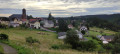
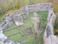
A lovely forest walk offering views over Wangenbourg Engenthal at the start. The route passes close to the Rocher du Dabo, overlooked by the Chapel of Saint-Léon, which you can visit by taking a detour of about 30 minutes, and/or you can also visit Dabo in 20 minutes. You can also enjoy a lovely view from the Himbeerfels, provided it isn’t obscured by the treetops. Finally, Obersteigen is home to a beautifully restored 13th-century chapel.

Details

837987
Creation:
Last update:
Last review:
  • Walking
    Activity: Walking
  • ↔
    Distance: 10.62 mi
  • ◔
    Average duration: 6h 45 
  • ▲
    Difficulty: Difficult

  • ⚐
    Back to start: Yes
  • ↗
    Ascent: + 2,169 ft
  • ↘
    Descent: - 2,142 ft

  • ▲
    Highest point: 2,441 ft
  • ▼
    Lowest point: 1,191 ft

Description of the walk

Park in Wangenbourg town centre, at 28–30 Rue du Général de Gaulle in the central car park, near the church.

(S/E) Walk up Rue du Général de Gaulle to the left as you leave the car park, towards the town hall. At the junction before the town hall, turn left onto Rue Impasse de l’Escalier. At the edge of the forest, at a place known as Le Haut de l’Escalier, join theGR®531(marked with a Blue Rectangle) and theGR®53 (marked with a Red Rectangle).

(1) Turn right onto either of theGR® routes; they run parallel and join at the Schleifmuhl junction.

(2) Carry on to cross a small bridge over the Mossig, then the D224. Pass the Rosskopf Forest House and continue on to reach the Col de la Schleiff.

(3) Turn right, staying on the GR®.

(4) Leave the track and take the path on the left.

(5) At the junction, take thesecond path on the left. Stay on this path to go round the Schlosskopf. Walk past the Dabo campsite and then reach the D45.

(6) Cross the road, walk past the mountain hut and continue along a forest track, then a path that descends slightly to the left. Cross a track and then a stream at the lowest point, and climb slightly to reach another junction.

(7) Leave theGR® here and take the path marked with a Red Disc to the right. Continue uphill until you rejoin the D45 at the hamlet of Barbelsahn.

(8) Turn left onto it for about a hundred metres and reach the junction withthe GR® 532, signposted with a Yellow Rectangle. Turn right and continue the climb to the Col du Himbeerfels.

(9) Turn left and then reach the junction with the Sentier du Rocher du Himbeerfels. Leave theGR® and turn left onto the path marked with a Yellow Cross. Reach the rock and then descend along the ridge to reach the D143 and the GR®.

(10) Carry on to the left along theGR®, running parallel to the road. Continue along a good forest track, passing the fountain known as the Goldbrunnen, and reach Obersteigen via the road.

(11) Turn left for a few metres to visit the 13th-century chapel signposted in the centre of the village, then return to the main road.

(11) Follow the path downhill opposite, cross afirst road, then asecond at the hamlet of Steigenbach.

(12) Walk up the path opposite, then continue with care along the D218 to return to the car park in the centre of the village of Wangenbourg (S/E).


Waypoints

  1. S/E : mi 0 - alt. 1,509 ft - Car park in the village centre - Église Saint-Barthélémy (Wangenbourg)
  2. 1 : mi 0.25 - alt. 1,608 ft - Top of the stairs
  3. 2 : mi 1.69 - alt. 1,506 ft - Junction of two GR trails
  4. 3 : mi 2.94 - alt. 2,260 ft - Col de la Schleif (689m)
  5. 4 : mi 3.28 - alt. 2,142 ft - Path on the left
  6. 5 : mi 4.18 - alt. 1,929 ft - Trail junction
  7. 6 : mi 4.77 - alt. 1,759 ft - Dabo campsite
  8. 7 : mi 5.52 - alt. 1,647 ft - Junction of the GR53 and Red Disc
  9. 8 : mi 5.95 - alt. 1,965 ft - A place called Barbelsahn
  10. 9 : mi 6.78 - alt. 2,365 ft - Himbeerfels Pass
  11. 10 : mi 8.17 - alt. 1,762 ft - D143 road
  12. 11 : mi 9.14 - alt. 1,526 ft - Obersteigen
  13. 12 : mi 9.67 - alt. 1,198 ft - Steigenbach
  14. S/E : mi 10.62 - alt. 1,509 ft - Car park in the village centre - Église Saint-Barthélémy (Wangenbourg)

Notes

(3) At the Col de la Schleiff, there is a large area with shelters, benches and tables.
(6) At the Dabo campsite, there are also tables and benches where you can have a picnic.

Always be cautious and plan ahead when you're outdoors. Visorando and the author of this route cannot be held responsible for any accidents occurring on this route.

The GR® and PR® markings are the intellectual property of the Fédération Française de Randonnée Pédestre.

Reviews and comments

3.9 / 5
Based on 3 reviews

Reliability of the description
4 / 5
Ease of following the route
4.3 / 5
Route interest
3.3 / 5
ZADIG
ZADIG

Overall rating : 4 / 5

Date of your route : Sep 07, 2026
Reliability of the description : ★★★★☆ Good
Ease of following the route : ★★★★☆ Good
Route interest : ★★★★☆ Good
Very busy route : No

A lovely walk – we changed our route by following the various GR trails

Machine-translated

Guigues
Guigues

Overall rating : 3.7 / 5

Date of your route : Apr 05, 2023
Reliability of the description : ★★★★☆ Good
Ease of following the route : ★★★★☆ Good
Route interest : ★★★☆☆ Average
Very busy route : No

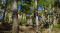
A route mainly through pine forests. Ideal in hot weather. Not much in the way of views. There’s a good restaurant along the route: Zollstock – booking essential – with some lovely rock formations towards the end of the route

Machine-translated

Guigues
Guigues
• Edited:

Overall rating : 4 / 5

Date of your route : Apr 05, 2023
Reliability of the description : ★★★★☆ Good
Ease of following the route : ★★★★★ Very good
Route interest : ★★★☆☆ Average
Very busy route : No

Best done in summer as it’s very wooded and very shady. There aren’t many views, which is a shame.
For a break halfway along the route, there’s an exceptional restaurant at Zollstock.
Beautiful rock formations at the end of the walk

Machine-translated

Other walks in the area

For more walks, use our search engine .

The GPS track and description are the property of this route's author. Please do not copy them without permission.