Country:
 City:


The walk starts in the Sainte-Anne neighbourhood of the village of Saint-Pierre, on Chemin de Beaucas: parking is available along the path.
(S/E) Head towards Rue des Louardes, pass a wash house and, at the junction with Chemin des Campaux, turn left. Then take the first track on the right towards Bastide Neuve.
(1) Take the first path on the left to continue along the edge of the field. At the end of this, join a track.
(2) Turn left and you’ll come to an X-junction. Carry on straight ahead for 20 metres, then turn right onto the small path leading uphill. At the junction with a track, carry on straight ahead, join another track and continue straight ahead again until you reach another junction with a small blue sign.
(3) Turn left and make sure you keep heading in the same direction. Walk alongside a copse on your left until you reach a crossroads.
(4) Go straight on for about a hundred metres, then turn right, heading due south. Pass a small pond on your left and join a small road.
(5) Turn right and carry on straight ahead at the first junction.
(6) At the top of the hill, turn right onto Chemin des Blacas, then left onto the downhill road, staying on Chemin des Blacas.
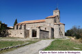
(7) At the bottom of the hill, take the hairpin bend to the left onto the street called Chemin de la Mourotte, then take the first street on the right to see the Notre-Dame d’Église Chapel. Return to the street and continue uphill for about twenty metres.
(8) At the Y-junction, take the track slightly to the right, below the road, to reach the wash house.
(9) Turn right onto the small path called Notre-Dame de l’Église and carry on straight ahead to join Chemin de la Mourotte.
(10) Turn left and join the D554.
(11) Turn left, cross the road at the pedestrian crossing on the bridge, and continue towards the village. Walk past the cemetery and go round the roundabout on the right.
(12) Turn right onto Route de Rians, cross the bridge over the stream and turn left
(13) Just before a building, take a small path leading uphill to the right, join a road and continue to the right. Once at the Y-junction, keep right onto Chemin de l’Ange towards Hemest.
(14) At the end of the track, turn right onto Chemin de l’Ange, take the second track on the right marked ‘dead end’, then turn right again onto a track. Go through the barrier to keep cars out and continue along the track to reach Notre-Dame de la Salette.
(15) Turn back.
(14) Carry on straight ahead, staying on Chemin de l’Ange.
(16) At the end of the street, turn left, then turn right onto Chemin du Pigeonnier at the first junction. Keep to the right at the Y-junction, then veer right before the Pigeonnier buildings. The road turns into a track and leads to a multi-path junction.
(17) Turn right between the two stones, then carry on straight ahead, passing some small ponds.
(18) At the track junction just after this, turn left towards the hamlet of Bourdas. When you reach the hamlet, take the first road on the right to join the D554.
(19) Turn right, cross the road carefully at the pedestrian crossing, and continue straight ahead along the track called Chemin des Drovers' Roads to cross the Terre des Rois woodland. Join a dirt track, continue straight on, pass between the stones and join the D36.
(20) Cross with care, then take a short first turn right then left to follow the D236 towards Saint-Julien.
(21) Take the first road on the right, Chemin Sous la Roche, and about a hundred metres before the cemetery, at the fire hydrant, turn right onto the descending path to join the Route du Pigeonnier (D35).
(22) Cross with care, continue straight on along Chemin des Guis, then immediately take the track on the left. After crossing the bridge over the Ruisseau de Beaucas, join a track and turn right to
return to the car park (S/E).

 Visorando Member
 Easy

 Moderate