A circular walk starting from Mercus-Garrabet

An easy circular walk starting from Mercus-Garrabet and leading to the Pont du Diable.

Details

46311403
Creation:
Last update:
Last review:
  • Walking
    Activity: Walking
  • ↔
    Distance: 5.34 mi
  • ◔
    Average duration: 2h 55 
  • ▲
    Difficulty: Easy

  • ⚐
    Back to start: Yes
  • ↗
    Ascent: + 509 ft
  • ↘
    Descent: - 492 ft

  • ▲
    Highest point: 1,752 ft
  • ▼
    Lowest point: 1,385 ft

Photos

Description of the walk

Park in the Mercus-Garrabet tennis court car park.

(S/E) Take the path below the tennis courts and head for the bridge. Cross it.

(1) Turn right and follow the path between the lake and the four-lane road, continuing towards the Mercus dam. Before reaching the dam, turn left to pass under the four-lane road and arrive at a Y-junction.

(2) Turn right onto the road. Follow it uphill and then downhill. You’ll rejoin the four-lane road and follow it until you reach another underpass.

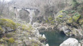
(3) Go under the four-lane road again, follow it along the path on the left and turn right to reach the Pont du Diable on the descent.

(4) Cross the bridge, continue along the road and, at the next junction, keep to the right, running parallel to the railway line. You’ll come to a level crossing.

(5) Leave the road here and continue along the path running parallel to the railway line. Cross the bridge, follow the path back up to rejoin the road and reach a bridge.

(6) Turn right away from the railway line and begin a gentle descent to reach the Garrabet Dam.

(7) Walk along the right-hand bank of the lake to Anse de la Carlasse.

(8) Here, turn left away from the lake to follow the railway line once more. Head towards the Pradalis neighbourhood, then return to the Mercus-Garrabet tennis courts car park (S/E).

Waypoints

  1. S/E : mi 0 - alt. 1,558 ft - Mercus-Garrabet tennis courts car park - Gare de Mercus-Garrabet-Centre
  2. 1 : mi 0.26 - alt. 1,522 ft - Mercus Bridge - Ariège (rivière)
  3. 2 : mi 1.26 - alt. 1,594 ft - Amplaing
  4. 3 : mi 2.24 - alt. 1,509 ft - Underpass
  5. 4 : mi 2.99 - alt. 1,385 ft - Pont du Diable
  6. 5 : mi 3.36 - alt. 1,562 ft - Level crossing
  7. 6 : mi 4.01 - alt. 1,594 ft - Bridge
  8. 7 : mi 4.34 - alt. 1,526 ft - Lake Garrabet
  9. 8 : mi 4.73 - alt. 1,558 ft - Anse de la Carlasse
  10. S/E : mi 5.34 - alt. 1,558 ft - Mercus-Garrabet tennis courts car park

Worth a visit

Between (2) and (3), an alternative route leads to the Montoulieu Tower. If you take this route, you will need to descend via Ginabat to return to the Pont du Diable via a path clearly marked with yellow signposts.

Reviews and comments

3.5 / 5
Based on 4 reviews

Reliability of the description
3.7 / 5
Ease of following the route
3.3 / 5
Route interest
3.5 / 5
LIONEL13118
LIONEL13118
• Edited:

Overall rating : 4 / 5

Date of your route : Jun 12, 2026
Reliability of the description : Not used / Not applicable
Ease of following the route : Not used / Not applicable
Route interest : ★★★★☆ Good
Very busy route : No

Thank you so much for sharing that – it was brilliant!

Machine-translated

User 26149388

Overall rating : 3.7 / 5

Date of your route : Jun 11, 2025
Reliability of the description : ★★★★☆ Good
Ease of following the route : ★★★☆☆ Average
Route interest : ★★★★☆ Good
Very busy route : No

Initially well marked, then complicated because there were no more signs... a few kilometres... then again... then no more, etc. In addition, there were paths where the grass was waist-high.

Machine-translated

Tcha
Tcha

Overall rating : 3 / 5

Date of your route : Aug 14, 2024
Reliability of the description : ★★★☆☆ Average
Ease of following the route : ★★★☆☆ Average
Route interest : ★★★☆☆ Average
Very busy route : No

The description lacks detail, as it does not specify the journey times for the different sections or any significant landmarks.
The tennis courts are not easy to find. They are situated below the village, within a sports complex.
The path leading down from there runs alongside a small stream for 10 to 15 minutes.
The bridge you need to cross is a road bridge over the Ariège.
Heading towards 2: the path beneath the four-lane road is neither signposted nor maintained; a resident of Amplaing pointed it out to us.
We wasted a lot of time looking for this path, and we didn’t get any further than the ‘Y-junction’.
The main attraction of this route is that it’s flat. The section running alongside the four-lane road isn’t very pleasant.
As for the rest, beyond the Pont du Diable, that will have to wait for another time.

Machine-translated

SABINE80
SABINE80

Overall rating : 3.7 / 5

Date of your route : Apr 20, 2024
Reliability of the description : ★★★★☆ Good
Ease of following the route : ★★★★☆ Good
Route interest : ★★★☆☆ Average
Very busy route : No

A short, easy walk with very little elevation gain. It took us barely two hours, not counting breaks. The only point of interest is the Devil’s Bridge. It’s a shame, though, that the traffic noise – which varies in intensity along most of the route – quickly becomes unbearable. As we couldn’t find the tennis courts at the start, we set off from the bridge next to the water sports centre, thinking we’d find them at the end of the route, but they remained nowhere to be seen. We didn’t take the detour up to the Montoulieu Tower as there were no time estimates given, but this detour is actually between points 2 and 3 (not between 3 and 4 as indicated).

Machine-translated

Other walks in the area

For more walks, use our search engine .

The GPS track and description are the property of this route's author. Please do not copy them without permission.