On the heights of the Vianon through peaks and woods

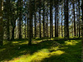
Follow the peaceful course of the River Vianon before climbing towards the peaks, a hike combining the coolness of the forest with a sunny summit. You can enjoy a refreshing break by the river.

Details

91242291
Creation:
Last update:
Last review:
  • Walking
    Activity: Walking
  • ↔
    Distance: 4.25 mi
  • ◔
    Average duration: 2h 15 
  • ▲
    Difficulty: Easy

  • ⚐
    Back to start: Yes
  • ↗
    Ascent: + 381 ft
  • ↘
    Descent: - 404 ft

  • ▲
    Highest point: 2,520 ft
  • ▼
    Lowest point: 2,103 ft

Description of the walk

Access to this walk is via the D171. Take the road towards the hamlet of Le Bouchaud and then Les Maisons Neuves. You can park at the junction where the walk starts, along the forest track, whilst leaving enough space for others to pass.

(S/E) Take the forest track heading north-east until you reach a fork.

(1) Turn left and continue straight on.

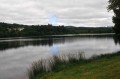
(2) Turn right into the forest to reach the Vianon stream: you can enjoy the coolness of the water, even take a dip, and perhaps let your dogs have a swim. Continue along the forest track until you reach a fork about 2 km further on.

(3) Leave the forest path by taking a path that climbs to the left.

(4) Pass under a power line and continue south-west to the crossroads by the mast.

(5) Turn left onto the forest path and continue for about 2 km until you reach Maison Neuve.

(6) Continue straight ahead along a small path opposite, crossing through the woods and passing under the power line again.

(7) At the junction, turn left to join the road to the hamlet of Maison Neuve.

(8) Follow it to the left until you reach the car park (S/E).

Waypoints

  1. S/E : mi 0 - alt. 2,142 ft - Maison Neuve
  2. 1 : mi 0.31 - alt. 2,267 ft - Junction
  3. 2 : mi 0.47 - alt. 2,264 ft - Junction towards the - Vianon (rivière) - Affluent de la Luzège
  4. 3 : mi 1.66 - alt. 2,300 ft - Junction on the uphill path
  5. 4 : mi 1.82 - alt. 2,333 ft - Power line
  6. 5 : mi 2.31 - alt. 2,484 ft - Antenne Crossroads
  7. 6 : mi 3.54 - alt. 2,280 ft - Crossroads
  8. 7 : mi 3.96 - alt. 2,152 ft - Crossroads
  9. 8 : mi 4.2 - alt. 2,126 ft - Route de Maison Neuve
  10. S/E : mi 4.25 - alt. 2,142 ft - Maison Neuve

Notes

Unmarked.

Dogs welcome.

(S/E) You can park at the edge of the forest, leaving space on the forest path.

After passing marker (1), you will walk alongside the Vianon and at point (2) you can even stop by the water’s edge, perhaps even take a dip or let your dogs cool off.

Other walks in the area

For more walks, use our search engine .

The GPS track and description are the property of this route's author. Please do not copy them without permission.