Country:

 City:
City:


Parking is available for a few cars at the Col de Masserange.
(S/E) Follow the D228 towards Masserange and drive through the hamlet.
(1) Leave the tarmac road and continue straight on along the forest track towards the Arboretum.
(2) Before the Arboretum, after about 800 m, take the first path on the right at a right angle. Head uphill alongside a wood, following the yellow markings and running alongside the field on the left (signpost for l’Averset and Saint-Sébastien, hidden behind the tree).
(3) Continue along the path, following the yellow markings, until you reach a forest track at the bottom of the descent.
(4) Turn left onto it and follow it for 150 to 200 metres (towards Pont de Marigot).
(5) Leave the forest track and take the path on the right (yellow markings).
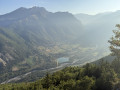
(6) After 400 m along the path, you can turn right at the three-way junction (Yellow Cross) to reach the D227 forest road and a viewpoint overlooking the Obiou and the northern Dévoluy, the Drac upstream of the Cognet dam, and the Écrins massif. Steep path.
(7) Retrace your steps.
(6) Continue along the path to the right and begin the ascent after a few hundred metres.
(8) Almost at the top of the climb, leave the path and take the narrow track that branches off to the left (leave the yellow markings – follow the Yellow Cross). Continue uphill to the forest road. Turn right and follow this forest road to the Arboretum.
(9) Cross the car park and join the signposted path on the right (signposted “Accès sentier” or “Saint-Jean d’Hérans” if you head slightly further up into the arboretum).
(10) At the Marignot signpost: you can follow either path, as both routes eventually join up. The path on the right leads to the Route de Saint-Jean d’Hérans in Masserange. Follow the track on the left at the bottom of the descent to head back up towards the D228.
(11) Follow this road to the left and head up towards Masserange for about 250 metres.
(12) Take the track on the right, which will lead you back to the Col de Masserange. At the top, turn left onto the D228 to return to the starting point (S/E).
 Visorando Member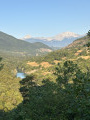

 Difficult
 Easy
Easy