Pont Blanc Heritage Trail via the circular route of the Canaux

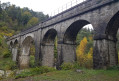
What a rich heritage is on display all along this circular route. A railway heritage where trains have never actually run. Right from the start at the Gare car park, don’t look for the station – it was never built. Roman heritage along the magnificent Roman road in this mountainous region. Heritage relating to water management: aqueducts, canals and waterwheels. Agricultural heritage unique in France: the Champsaur mountain bocage. Built heritage: a chapel, a bread oven and farmhouses. In short, you can explore all this heritage at your own pace.

Details

41708481
Creation:
Last update:
Last review:
  • Walking
    Activity: Walking
  • ↔
    Distance: 7.83 mi
  • ◔
    Average duration: 4h 25 
  • ▲
    Difficulty: Moderate

  • ⚐
    Back to start: Yes
  • ↗
    Ascent: + 984 ft
  • ↘
    Descent: - 968 ft

  • ▲
    Highest point: 4,242 ft
  • ▼
    Lowest point: 3,455 ft

Photos

Description of the walk

In Forest-Saint-Julien on the D114, park at the Gare car park.

(S/E) Follow the grassy path (an old railway line) then, at the start of the Courbe du Pont de Frappe (retaining walls), look out for the path on the left that climbs towards La Voie Romaine.

(1) Leave the railway line and turn left. Follow the flat path until you reach a lovely stony path – this is the Voie Romaine. Turn right onto it and head uphill, cross the D944 with care, then continue to the junction by the canal.

(2) Leave the path and turn left onto the flat path to reach the Aqueduc des Gorges.

(3) Return to the junction by the canal.

(2) Turn left onto the ascending path and follow the Roman Road to the Oratoire crossroads.

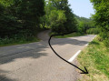
(4) Turn left onto the tarmac road, pass the Oratory and then some houses, and arrive at a bend at the Carrefour des Gorges.

(5) Carry on straight ahead along the path to follow the canal known as the Biaou du Forest. The path continues through the woodland, then crosses the canal and eventually climbs back up to the Biaou de Manse junction.

(6) Turn sharply right – a 180° turn – onto the path heading due west towards Manse. Follow this path again as it runs alongside the canal known as the Biaou de Manse. The path runs flat through the woodland before joining a dirt track in an open area directly beneath a power line.

(7) Turn right and follow this track downhill until you reach a tarmac road at the Peyres crossroads.

(8) Cross it and continue downhill, first along a footpath, then onto another tarmac road. Continue downhill until you reach a crossroads at the entrance to the village of Manse.

(9) Cross the D994 with care. Walk past the town hall and the church, then continue along the tarmac road until you reach the hamlet of Les Bardannes. Walk through the hamlet and, at the other end, you’ll find the Les Bardannes crossroads.

(10) Turn right onto the footpath, follow the Riou Gros stream, then leave it to reach thefirst houses of Serre Richard.

(11) Turn left, then immediately right onto the tarmac roads. Then turn right onto Rue du Four to reach the chapel in Serre Richard, followed by the ‘four banal’ crossroads.

(12) Turn left and continue along the road to the next four-way junction, which is also where the old railway line used to be.

(13) Turn right onto this track. Carry on straight ahead, admiring the many engineering features: low walls, ditches and bridges. You’ll reach the Riou Faubert bridge.

(14) Take a detour here, passing under the bridge and then back up again. Pass by the viewing point and then round the bend at the Pont de Frappe, before reaching the station car park (S/E).


Waypoints

  1. S/E : mi 0 - alt. 3,458 ft - Forest-Saint-Julien railway station car park
  2. 1 : mi 0.09 - alt. 3,484 ft - Crossroads at the start of the Courbe du Pont de Frappe
  3. 2 : mi 0.45 - alt. 3,658 ft - Carrefour du Canal
  4. 3 : mi 0.85 - alt. 3,635 ft - Gorges Aqueduct
  5. 4 : mi 1.56 - alt. 3,871 ft - Carrefour de l’Oratoire
  6. 5 : mi 1.77 - alt. 3,930 ft - Carrefour des Gorges
  7. 6 : mi 3.2 - alt. 4,180 ft - Biaou de Manse crossroads
  8. 7 : mi 3.76 - alt. 4,180 ft - Crossroads directly beneath the power line
  9. 8 : mi 4.67 - alt. 4,009 ft - Carrefour des Peyres
  10. 9 : mi 5.15 - alt. 3,822 ft - Manse Crossroads
  11. 10 : mi 5.66 - alt. 3,750 ft - Carrefour des Bardannes
  12. 11 : mi 6.07 - alt. 3,652 ft - Entrance to Serre Richard
  13. 12 : mi 6.5 - alt. 3,652 ft - Four Banal
  14. 13 : mi 6.68 - alt. 3,622 ft - La Ligne crossroads
  15. 14 : mi 7.36 - alt. 3,563 ft - Riou Faubert Bridge
  16. S/E : mi 7.83 - alt. 3,461 ft - Forest-Saint-Julien railway station car park

Notes

Take water with you as there are no drinking fountains along the route.
The circular route can be shortened by two hours if you do not wish to take the ‘La Variante des Canaux’ route. To do this, at La Roue in Aubes, continue along the tarmac road to the Carrefour des Peyres (8). Then follow the rest of the walk description as normal.
If you wish to shorten the circular route, you can also, just before the bridge and the Carrefour des Bardannes (10), turn right onto the Riou Gras path (or Sentier des Morts) and arrive directly at La Ligne.
Take care when crossing roads and on tarmac sections.
This walk often takes place in woodland, which is pleasant in good weather; otherwise, take the necessary precautions.

Worth a visit

(3) Aqueduc des Gorges – do make sure to visit it.
(5) Carrefour des Gorges: stay on the road and continue along the tarmac road for 150 metres to see the Roue à Aubes.
Throughout the walk, there are numerous information boards about the local heritage; do take the time to read them – it’s well worth it.

Reviews and comments

4.4 / 5
Based on 3 reviews

Reliability of the description
4.7 / 5
Ease of following the route
4.7 / 5
Route interest
4 / 5
Annick84
Annick84

Overall rating : 3.3 / 5

Date of your route : Jul 27, 2026
Reliability of the description : ★★★★☆ Good
Ease of following the route : ★★★★☆ Good
Route interest : ★★☆☆☆ Disappointing
Very busy route : No

The main attraction is limited to the first part (the castle) – a lovely shaded area which is particularly welcome during a heatwave; the rest is simply a stroll along the canals; disappointing for us, but certainly suitable for those looking for an easy walk.

Machine-translated

Serge Launay
Serge Launay

Overall rating : 5 / 5

Date of your route : Aug 01, 2025
Reliability of the description : ★★★★★ Very good
Ease of following the route : ★★★★★ Very good
Route interest : ★★★★★ Very good
Very busy route : No

Very nice hike, no technical difficulties, very shaded except for the loop in the hamlet of Serre Richard, but that can easily be skipped, and it was so peaceful, we hardly saw anyone...thank you for this route

Machine-translated

patembrun
patembrun

Thank you very much for your feedback. In any case, well done on completing this hike right in the middle of February. I hope it wasn’t too tough. As for the tarmac section, I’m sorry, but if you want to follow the entire railway line, this tarmac section is more or less unavoidable. However, if you want to avoid it, you can do so as I suggest in the guide: at the Bardanes crossroads (marker 10), leave the road and turn right onto the footpath, which will take you back to the railway line but in the middle of it. Enjoy your walks.

Machine-translated

Christine  G
Christine G

Overall rating : 5 / 5

Date of your route : Feb 26, 2024
Reliability of the description : ★★★★★ Very good
Ease of following the route : ★★★★★ Very good
Route interest : ★★★★★ Very good
Very busy route : Yes

A very well-signposted trail with interesting information and varied scenery; the only downside is that the final stretch along the tarmac road, passing by the communal oven and chapel (which are closed), is of no interest.

Machine-translated

Other walks in the area

For more walks, use our search engine .

The GPS track and description are the property of this route's author. Please do not copy them without permission.