Country:

 City:
City:


(S) From the Nino Sardi mountain hut, the route begins with a very steep descent (on the Italian side, therefore) along a good path.
(1) After passing a small, unnamed pass at 2,412 m, be sure to keep right, leaving the path on the left that descends to Alpe Crosenna (where you can sample some excellent cheese at the refuge). The climb up to the Col de Malaure is quite steep and can be tricky if there is lingering snow.
(2) At the Col de Malaure, descend along the path on the French side to around 2,400 m.
(3) Then turn left (south-west). There are good drovers' roads that allow you to cross at a more or less constant level at the start. Then continue as best you can to cross a first ridge, then a second. As any ‘unpleasant surprises’ are right in front of you, there’s nothing to fear once you’ve reached the other side. You’ll thus reach the Col d’Urine path fairly easily and arrive at the pass.
(4) The rest of the route follows a well-marked path, though it can sometimes be a little eroded in the ravines. A long, rather monotonous descent through a valley full of scree. You’ll reach the Jervis refuge, where you’ll find the lowest point.
(5) Head south along a long, very flat stretch at the bottom of a remarkable glacial valley: an agricultural area where you can buy cheese or milk. There are two routes to the Granero refuge. Personally, I followed the GTA. It climbs quite steeply to cross an initial ridge.
(6) Carry on until you reach a flat area where a memorial stone and a piece of aeroplane engine serve as a reminder of the crash of an American aeroplane and its crew, which occurred after the war. You then need to cross a second pass to reach the Granero refuge via an easy path. It’s time to take a breather before going to admire the reflection of the Granero in Lago Lungo (E).

 Visorando Member
 Association / Club / Walk leader
 Very difficult
  Moderate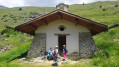
 Easy
Easy