Country:
 City:
City:


When arriving in Locquénolé from the north via the D73, at the roundabout just after the large sign for “Église de Saint-Guénolé”, near a park, turn right and then immediately enter the car park on the right.
Yellow markings
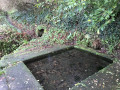
(S/E) Head towards the park’s pond and, with your back to the River Morlaix, take a path through the park towards the village centre. Look for sign no. 1, “In the footsteps of Mathurine”, and continue in the same direction towards the church. At the crossroads, look out for the fountain and the wash house , along with its information sign (No. 2). Depending on the season, the wash house may be overgrown with vegetation, as is often the case in villages: no longer in use, they have become micro-wetlands, and this vegetation provides a habitat for amphibians and insects.
Continue along the lane to reach Saint-Guénolé Church, with its colourful interior, painted beams, pretty ‘pardon’ banners, a small wayside cross outside, a fountain on the other side of the street, and the first notable tree – a ‘Tree of Liberty’ oak planted in 1794, with its information panel (no. 3).
(1) Next, head towards the town hall (with a small pond below) then turn right, leaving the town hall on your left. The road gives way to a pedestrian path. At the junction, first turn right then left to follow a path which leads straight on (ignore the footbridge on the left) to the Prat Santec Washhouse and its sign (no. 4).
(2) In front of the washhouse, turn left onto the street, pass the school car park on your right, then take a path on the right, marked by a wooden sign indicating the direction of the trail. Further on, walk past a fairly recent orchard (planted in 2026) with a sign listing the 15 varieties of apple tree grown here. Where the path bends to the right, carry straight on along the grassy path. You’ll come to information sign no. 5 , ‘The Trees of Saint-Guénolé’.
(3) Note two magnificent chestnut trees on the left (estimated age 500 years), then shortly afterwards, on the right-hand side of the path, a majestic yew tree (estimated age 800 years). Continue along the path; at the junction, turn left to join a road and follow it to the right. Turn right at the next street, which quickly becomes a footpath.
(4) You’ll pass sign no. 6, “Le Passeur au Bruly”, and, from these heights, enjoy a view of the River Morlaix and a beautiful house on the opposite bank. Continue along the path through the woodland, passing sign no. 7, “Les huitres de la Baie”. At the junction, turn right, then left onto the street.
(5) At the T-junction, turn right onto Rue du Clémeur and keep right onto this street at the next junction. You’ll come to the road running along the coast; follow it to the left on the pavement, then cross it shortly afterwards at the pedestrian crossing to take a path opposite towards the river, arriving at sign no. 8 , “Les régates de la Baie de Morlaix”. Continue along the path beside the river, then join the road on the left and cross it at the pedestrian crossing by the park, and head to the car park (S/E).
 Visorando Member
 Moderate
 Educational project