Country:

 City:
City:


Park in the car park ofthe Hôtel des Sources de la Nive (327m), south of the village of Estérençuby.
(S/E) Return to the access road (D428) and turn right to pass above the hotel. You’ll arrive at Beherobiko Borda.
(1) Cross the bridge over the Nive and follow the narrow, muddy, winding path which climbs and rejoins the road at a hairpin bend.
(2) Head left for a few metres, then turn left again onto a track leading to the Matxardenea farmhouse.
(3) At this point, the track is not obvious as you enter the ferns, but you can follow it; this may be even more difficult once the vegetation has finished growing. Join the path that winds up a steep slope, climb up and rejoin the D428. Follow it to the left for about 150 metres.
(4) Take the path on the left, which rejoins the D428; follow it to the left until you reach the small car park.
(5) Turn off, once again to the left, to follow the small road leading to the Col d’Organbide (988 m).
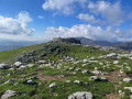
(6) Cross over to the Spanish side and continue along the long ridge on the Hegoalde side, heading south-east.
(7) Pass Saiare, a secondary peak, and continue along this flared ridge, catching a glimpse of the Harpea cave below.
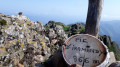
(8) Pass Ezkanda (1,203 m) and continue along this ridge, specifically following the Atlantic–Mediterranean watershed: the Nive catchment area and the Rio Irati and Ebro catchment areas. You’ll reach a small pass where there’s a signpost indicating the routes (1,164 m) and where the trail joins a red-and-white marked route.
(9) Continue straight ahead, following these markings to reach another small pass.
(10) Leave the marked trail and head straight ahead, climbing from the east up a slope that is gentle at first but becomes steeper as you approach the summit of Mendizar (1,319 m or 1,323 m depending on the map. Take in this vast, awe-inspiring panorama during your picnic break: magnificent views of the forests of Iraty and Orion, the Pic d’Orhy and the Urkulu in particular.
(11) Then head left, northwards, to the nearby twin peak (Mendizar is a double-peaked mountain) (1,318 m).
(12) Then head left (west) to walk along the grassy ridge overlooking the Barra de Armalda (Errandiko Bizkarra).
(13) Continue northwards towards the Col d’Errozate (1,072 m).
(14) Descend to the left via the HRP into the valley, with its vibrant greenery, down steep grassy slopes.
(15) At the path junction, leave the path leading to the Harpea Cave on your left and carry straight on. Further on, rejoin the outbound route at Beherobiko Borda.
(1) Follow the track and the small tarmac road to reach the hotel car park (S/E).
Note: this circular route was completed on 6 September 2021, 24 June 2023 and 30 May 2025 with Richard’s group from the Randonneurs d’Anglet Accueille.
 Visorando Member
 Moderate
 Tourist office
 Easy
Easy 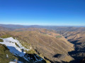
 Association / Club / Walk leader