The Valette Valley

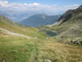
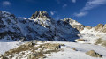
A true high-mountain experience is guaranteed on this beautiful walk in the Belledonne Massif at the foot of the Pic du Frêne

Details

2487928
Creation:
Last update:
Last review:
  • Walking
    Activity: Walking
  • ↔
    Distance: 5.86 mi
  • ◔
    Average duration: 5h 40 
  • ▲
    Difficulty: Difficult

  • ⚐
    Back to start: Yes
  • ↗
    Ascent: + 3,379 ft
  • ↘
    Descent: - 3,379 ft

  • ▲
    Highest point: 7,562 ft
  • ▼
    Lowest point: 4,183 ft

Description of the walk

The walk starts at the end of the Route Forestière des Essarts, 2 km above the forest chalet at the foot of La Combe.

(S/E) Head south-west along a well-marked path which, after a 15-minute walk, will take you to the Lescherette alpine chalets.

(1) When you reach the last chalet, carry on by crossing the stream. The path climbs steeply to reach a first plateau, where the Valette and Pierre valleys meet.

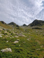
(2) Continue left towards the Valette valley until you reach the Valette chalets, then carry on to the stream.

(3) Then, on the right bank of the torrent, take a path that climbs up an old moraine to reach a second plateau, where you will find the Gollachon hut on your right.

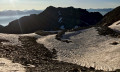
(4) From there, follow the torrent – now a stream – upstream to the spillway of Lac de la Valette.

(5) After a well-deserved break, head back along the same route to the end of the Route Forestière des Essarts (S/E).

Waypoints

  1. S/E : mi 0 - alt. 4,183 ft - End of the Route Forestière des Essarts
  2. 1 : mi 0.4 - alt. 4,560 ft - Lescherette Forest Ranger’s Cottage
  3. 2 : mi 0.92 - alt. 5,125 ft - Turn left towards La Valette
  4. 3 : mi 1.55 - alt. 5,797 ft - Right bank of the torrent
  5. 4 : mi 2.14 - alt. 6,568 ft - Gollachon Chalet
  6. 5 : mi 2.92 - alt. 7,562 ft - Lac de la Valette
  7. S/E : mi 5.86 - alt. 4,183 ft - End of the Route Forestière des Essarts

Notes

Make sure you bring water as the valley is very exposed to the sun in summer.

Reviews and comments

4.7 / 5
Based on 2 reviews

Reliability of the description
4.5 / 5
Ease of following the route
4.5 / 5
Route interest
5 / 5
ycol
ycol

Overall rating : 5 / 5

Date of your route : Oct 18, 2021
Reliability of the description : ★★★★★ Very good
Ease of following the route : ★★★★★ Very good
Route interest : ★★★★★ Very good
Very busy route : No

Please note: the sign states ‘No entry for all vehicles except those authorised to use the forest road’. Is this a strict ban or a disclaimer? Check with the town hall to avoid any inconvenience.

Machine-translated

maxremalian
maxremalian

Overall rating : 4.3 / 5

Date of your route : Jul 05, 2020
Reliability of the description : ★★★★☆ Good
Ease of following the route : ★★★★☆ Good
Route interest : ★★★★★ Very good
Very busy route : No

Please note: the section of the stream above the Valette chalets cannot be crossed – there is too much water in early July.
We headed straight through the willows and rhododendrons, keeping to the left bank to reach the Golachon hut and continue straight along the valley.

Machine-translated

Other walks in the area

For more walks, use our search engine .

The GPS track and description are the property of this route's author. Please do not copy them without permission.