A walk around the Étang de Bétineuc

This is a route suitable for families, even with pushchairs, as the path is accessible to people with reduced mobility.
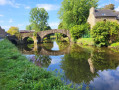
You’ll walk around this beautiful Costarmoricain lake, with a short detour onto the peninsula to feel as though you’re right in the middle of the water.

Details

n°3879896
Creation:
Last update:
Last review:
  • Walking
    Activity: Walking
  • ↔
    Distance: 1.93 mi
  • ◔
    Average duration: 0h 55 
  • ▲
    Difficulty: Easy

  • ⚐
    Back to start: Yes
  • ↗
    Ascent: + 3 ft
  • ↘
    Descent: - 3 ft

  • ▲
    Highest point: 43 ft
  • ▼
    Lowest point: 36 ft

Photos

Description of the walk

(S/E) From the car park, walk past the leisure centre buildings, keeping the beach on your left. Follow the entire north-western shore of the lake.

(1) Take the path furthest to the left and continue left to cross the dyke separating the two bodies of water. After the small bridge, turn left.

(2) When you reach a road, follow it to the left, with the pond on your left and the River Rance on your right. Walk past the Rove Goat Sanctuary on your right.

(3) You can turn left here for a short walk around the headland.

(3) Turn left again to reach the north-eastern edge of the pond.

(4) At the fork in the path, take the left-hand path, then continue left to walk along the beach. In front of the buildings, turn right to return to the car park (S/E).

Waypoints

  1. S/E : mi 0 - alt. 39 ft - Leisure Park car park
  2. 1 : mi 0.58 - alt. 39 ft - Path on the left
  3. 2 : mi 0.75 - alt. 43 ft - Turn left onto the road. On your right, the - Rance (fleuve)
  4. 3 : mi 1.14 - alt. 43 ft - Access to the peninsula
  5. 4 : mi 1.7 - alt. 39 ft - Path on the left
  6. S/E : mi 1.93 - alt. 39 ft - Leisure Park car park

Notes

A century ago, it was nothing more than a meadow. During the Second World War, the Germans turned it into an emergency airfield. The area was subsequently used as a sand quarry before finally being purchased by the departmental council and the local fishing federation, who developed it into a leisure centre towards the end of the 20th century.

Reviews and comments

5 / 5
Based on 1 review

Reliability of the description
5 / 5
Ease of following the route
5 / 5
Route interest
5 / 5
Virginie le helley
Virginie le helley

Overall rating : 5 / 5

Date of your route : Feb 17, 2025
Reliability of the description : ★★★★★ Very good
Ease of following the route : ★★★★★ Very good
Route interest : ★★★★★ Very good
Very busy route : No

Hello,
A very well-signposted and lovely route. Easy and suitable for people who have difficulty walking. There’s a small picnic area with a table, which is very handy.

Machine-translated

Other walks in the area

For more walks, use our search engine .

The GPS track and description are the property of this route's author. Please do not copy them without permission.