Country:

 City:
City:


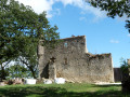
The walk starts from the car park behind Montfa Town Hall.
YellowPR® markings
(S/E) At the start, turn right (north-east) onto the Route de Montredon (D59), then continue straight on along the Route des Collines to the hamlet of Graviac.
(1) Continue to the right, heading down towards the Bagas Stream valley. Cross the stream via the road bridge, and continue for 150 m, without crossing the other road bridge.
(2) Head uphill to the right along a forest path and join the D4.
(3) Caution: busy road! Turn right onto this road and follow it for about 200 m.
No signposting
(4) Turn left, heading due east, onto a dirt track that slopes down slightly and leads to the hamlet of La Camboussié.
(5) Walk through the hamlet and, in the centre, you’ll find a country lane on your left heading north-east; follow this for 800 m.
(6) At the top of a short climb, turn right (east) onto the path that follows the ridge, towards a water tower visible in the distance. Continue straight on along the road you come to, pass the Reboulié farm, and arrive at a junction just before the D89.
(7) Turn left onto the small road that runs past the water tower, and you’ll reach another Y-junction.
(8) Carry on to the left, towards the hamlet of Le Verdier, and pass through it. The road becomes a stony track that cuts through a forest, descends into a small valley, and climbs back up to the Domaine du Triol.
(9) At the access path to the house, turn left, pass the hamlet known as ‘Gay’ and join a cross-road (D4). Continue to the right for about 300 m until you reach Les Fournials.
YellowPR® signposts
(10) Take the Route de Rudel on the left and follow it to the hamlet of Rudel. Go past the hamlet until you reach a crossroads.
(11) Turn left onto a narrow path through the woodland and, after crossing a meadow, you’ll reach a cross-country track.
(12) Turn sharply right, due west, onto the path that runs alongside the stream: signposted ‘Sentier des Puechs, long route’. You’ll reach the Plancarié farm, directly beneath a power line.
(13) Follow the small road through the woods until you reach another cross-country track.
(14) Turn left onto this road. Pass under the power line again and continue for about 100 metres.
(15) Turn right onto a path between the fields, passing under the power line once more.
(16) Go round the Quintaine estate and follow a path to the left, which remains at the same level.
(17) Turn left onto the path leading up towards the castle, passing under the power line once more.
(18) At the foot of the castle, head up to the left towards the esplanade opposite it. Stunning view.
(19) Turn back.
(18) Continue to the left, towards Boudet Farm, and follow the road until you reach a junction with another road.
(20) Follow the grassy path straight ahead. Cross a second road, and continue straight ahead along the path until you reach the next road.
(21) Turn right, towards the village.
(22) In the housing estate, continue to the left to reach the centre of Montfa and the town hall car park (S/E).

 Visorando Member
 Easy
Easy  Tourist office
 Association / Club / Walk leader