Piton de l’Entonnoir

Piton de l’Entonnoir is best known as a paragliding launch site. There are a few footpaths leading up to it. It offers a remarkable view of the south of the island! Guava enthusiasts will find plenty to enjoy on this very short walk. It is therefore strongly recommended that you combine this walk with another. The route is less than a kilometre long and is suitable for families with children.

Details

n°1234724
Creation:
Last update:
Last review:
  • Walking
    Activity: Walking
  • ↔
    Distance: 0.47 mi
  • ◔
    Average duration: 0h 25 
  • ▲
    Difficulty: Easy

  • ⚐
    Back to start: Yes
  • ↗
    Ascent: + 246 ft
  • ↘
    Descent: - 246 ft

  • ▲
    Highest point: 1,457 ft
  • ▼
    Lowest point: 1,211 ft

Description of the walk

How to get there: From Saint-Pierre: Head towards Saint-Joseph via the N1. Pass a ‘Score’ on your right and carry straight on at the next two roundabouts. Take the third exit, then the first exit at the following two roundabouts. Follow the road towards Bésave until you see the sign for Piton de l’Entonnoir and park nearby.

From Saint-Philippe: Head towards Saint-Joseph via the N1. Cross the Rivière des Rempart via a bridge, staying on the N1 throughout. At the roundabout, turn right. Take the third exit, then the first at the next two roundabouts. Follow the road towards Bésave until you reach the sign for Piton de l’Entonnoir and park nearby.

(S/E) Follow the track to where it ends. Further up, it turns into a footpath. Take this path. A clearing on the left offers a view of Piton Langevin (or Piton Lambert). The path climbs, passing close to a few lanterns.

(1) Carry on straight ahead at the junction. Guava trees are everywhere! There are guavas all over the place! It’s an ideal walk for picking them. After a few steps, you’ll reach the paragliding launch site.

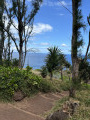
There’s a viewing point on the right. After this very short climb, enjoy the magnificent panorama stretching from Morne Langevin to Saint-Joseph, taking in Piton Bernard, Langevin, Grande Coude, La Crête, Jean Petit and Bésave.

Take the path that starts to the left of the viewpoint and the orientation table.
At the next junction, keep to the left. You’ll very quickly reach the junction you passed on the way there.

(1) Keep left and return to your vehicle via the same route you took on the way there (S/E)

Waypoints

  1. S/E : mi 0 - alt. 1,211 ft - D3
  2. 1 : mi 0.14 - alt. 1,322 ft - Crossroads on the circular loop
  3. S/E : mi 0.47 - alt. 1,211 ft - D3

Notes

Water available at Piton de l’Entonoir

Worth a visit

Places to see:

-Piton de l’Entonnoir and its viewpoint

Things to do:

-The walk is very short; I recommend combining it with the Piton Babet walk

Reviews and comments

4.2 / 5
Based on 2 reviews

Reliability of the description
4 / 5
Ease of following the route
4 / 5
Route interest
4.5 / 5
Chrijeapasteca
Chrijeapasteca

Overall rating : 3.7 / 5

Date of your route : Oct 24, 2022
Reliability of the description : ★★★☆☆ Average
Ease of following the route : ★★★☆☆ Average
Route interest : ★★★★★ Very good
Very busy route : Yes

The roadside sign pointing the way to the peak doesn’t exist… or no longer exists…!
In fact, about 500 metres past the KM 229 marker, park at the picnic area (on the left);
Walk back down to the road (about 150 metres) and turn right at the first bend (a concrete track leading uphill).

Machine-translated

danielfr40
danielfr40

Overall rating : 4.7 / 5

Date of your route : Jan 27, 2022
Reliability of the description : ★★★★★ Very good
Ease of following the route : ★★★★★ Very good
Route interest : ★★★★☆ Good
Very busy route : No

A lovely view after a short climb
Thanks for this route

Machine-translated

Other walks in the area

For more walks, use our search engine .

The GPS track and description are the property of this route's author. Please do not copy them without permission.