Margosiers Circular

A pretty circular above Saint-Joseph offering magnificent views of Grande Anse and the villages of Plaine des Grègues with their turmeric crops.

Details

1853236
Creation:
Last update:
Last review:
  • Walking
    Activity: Walking
  • ↔
    Distance: 10.56 km
  • ◔
    Average duration: 5h 30 
  • ▲
    Difficulty: Difficult

  • ⚐
    Back to start: Yes
  • ↗
    Ascent: + 874 m
  • ↘
    Descent: - 876 m

  • ▲
    Highest point: 1,378 m
  • ▼
    Lowest point: 646 m

Photos

Description of the walk

Before Saint-Joseph, turn towards Plaine des Grègues and stop in the car park in front of the church.

(S/E) Take the road to the right for about 100 metres, then turn left to the car park at the start of the trail.

(1) Take the path that climbs quite steeply (lots of steps) up the side of the mountain. The path is very well marked. Beautiful views of the village and the sea towards Grande Anse.

(2) Turn right at the fork. You will come to a few houses and a small road junction.

(3) Continue straight ahead until you reach the first fork in the path.

(4) Take the path on the left. At the first junction, take the left path and continue climbing for a good while up the mountainside. Further on, turn right onto the path and continue until you reach a signpost marked "Sentier des trois sources" (Three Springs Trail).

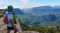
(5) Turn left and continue climbing. A sign indicates "Circular des Margosiers". Follow this path for a long time through beautiful vegetation with views of the villages of Plaine des Grègues, the coast and, on the right-hand side, beautiful mountains. The path is steep, very well marked and has many steps.

(6) You will reach the summit of Piton du Rond after a series of small climbs and steep descents. Be careful, as the ground can be very slippery. After that, you will tackle a steep and often slippery descent. There is no alternative route and the trail descends for a long time, alternating between views of the sea and the plain and dense vegetation. You will arrive at a crossroads.

(7) Turn left to continue the descent. There are still many steps before you reach a large crossroads.

(8) Follow the path on the left marked "Cascade Mottet" (it is not visible) and continue down the very steep descent.

(9) Finally, the path leads to a small road, which you follow straight ahead. Still on the road, turn left first, then take a wide right turn. Continue straight ahead through beautiful flower-filled huts before taking a wide left turn.

(10) Turn right onto Rue de l'Ilet. Continue straight ahead to reach the church (S/E).

Waypoints

  1. S/E : km 0 - alt. 650 m - Car park in front of the church.
  2. 1 : km 0.18 - alt. 655 m - Trail start
  3. 2 : km 1.21 - alt. 780 m - Right fork
  4. 3 : km 1.38 - alt. 787 m - Road junction
  5. 4 : km 1.52 - alt. 784 m - Left-hand path
  6. 5 : km 2.14 - alt. 858 m - Three Springs Trail
  7. 6 : km 4.98 - alt. 1,372 m - Piton du Rond
  8. 7 : km 6.85 - alt. 1,078 m - Left junction
  9. 8 : km 8.4 - alt. 915 m - Towards Mottet waterfall
  10. 9 : km 9.29 - alt. 672 m - Road junction
  11. 10 : km 10.19 - alt. 647 m - Rue de l'Îlet
  12. S/E : km 10.55 - alt. 650 m - Car park in front of the church.

Notes

It can rain frequently at these heights, making the route very slippery.
This little-known hike means you won't encounter many other walkers.

Worth a visit

The Turmeric House.

Reviews and comments

4.6 / 5
Based on 13 reviews

Reliability of the description
4.8 / 5
Ease of following the route
4.7 / 5
Route interest
4.3 / 5
fredchristine14
fredchristine14

Hello
It makes me want to go back, enjoy yourselves!

Machine-translated

User 8002582

Overall rating : 4.3 / 5

Date of your route : Oct 23, 2025
Reliability of the description : ★★★★★ Very good
Ease of following the route : ★★★★☆ Good
Route interest : ★★★★☆ Good
Very busy route : Yes

A lovely walk with beautiful views.

Machine-translated

User 8189494

Overall rating : 4.3 / 5

Date of your route : Nov 03, 2025
Reliability of the description : ★★★★★ Very good
Ease of following the route : ★★★★☆ Good
Route interest : ★★★★☆ Good
Very busy route : No

:love(love)love:

Machine-translated

Anne17
Anne17

Overall rating : 5 / 5

Date of your route : Sep 29, 2025
Reliability of the description : ★★★★★ Very good
Ease of following the route : ★★★★★ Very good
Route interest : ★★★★★ Very good
Very busy route : Yes

Path under the trees with beautiful views. Excellent training route, only uphill on the way there with high steps and therefore a slightly steep descent as well.

Machine-translated

fredchristine14
fredchristine14

Overall rating : 5 / 5

Date of your route : Mar 12, 2025
Reliability of the description : ★★★★★ Very good
Ease of following the route : ★★★★★ Very good
Route interest : ★★★★★ Very good
Very busy route : Yes

A challenging hike with lots of steep steps, extraordinary views of the river, ramparts and the grand coude. An ideal trail for trail runners. At the end, we took the curcuma trail and enjoyed visiting the Plaine des Gregues with its pretty houses and beautiful gardens. The local people were very friendly.

Machine-translated

Slep974
Slep974

Overall rating : 4.7 / 5

Date of your route : Feb 24, 2025
Reliability of the description : ★★★★★ Very good
Ease of following the route : ★★★★★ Very good
Route interest : ★★★★☆ Good
Very busy route : Yes

Superb circular, if you don't like walking, RUN AWAY 😅

Machine-translated

Didier Magnet
Didier Magnet

Overall rating : 3.3 / 5

Date of your route : Oct 23, 2024
Reliability of the description : ★★★★★ Very good
Ease of following the route : ★★★★☆ Good
Route interest : ★☆☆☆☆ Very disappointing
Very busy route : No

A hike with no particular interest or appeal. The hike takes place mainly in a tunnel of greenery with two viewpoints on the way up (on the Piton de la Fournaise side). There are no viewpoints when you reach the highest point.
The descent is quite steep.
Recommended if you want to train for an 800-metre climb on a slightly demanding route. Otherwise, it is better to choose another hike.

Machine-translated

Vercollier
Vercollier

Overall rating : 5 / 5

Date of your route : Oct 17, 2024
Reliability of the description : ★★★★★ Very good
Ease of following the route : ★★★★★ Very good
Route interest : ★★★★★ Very good
Very busy route : No

Quite a challenging trail. Beautiful circular with views of Grand Coude on the way up.
The weather is good.
Steep descent, so caution is advised.

Machine-translated

ppassade
ppassade

Overall rating : 4.7 / 5

Date of your route : Jul 15, 2024
Reliability of the description : ★★★★★ Very good
Ease of following the route : ★★★★★ Very good
Route interest : ★★★★☆ Good
Very busy route : No

A fairly challenging circular with lots of pleasant vegetation cover and some beautiful views. The descent is quite tricky and very steep. We were lucky that the trail was fairly dry, but in wet weather it must be very difficult.

Machine-translated

Kty974
Kty974

Overall rating : 5 / 5

Date of your route : May 20, 2024
Reliability of the description : ★★★★★ Very good
Ease of following the route : ★★★★★ Very good
Route interest : ★★★★★ Very good
Very busy route : No

Hike redone with the family. The route is perfect.
The views are superb
I found the end of the descent a bit tricky
A must-do 😍

Machine-translated

Orando974
Orando974 ★

Overall rating : 5 / 5

Date of your route : Dec 28, 2022
Reliability of the description : Not used / Not applicable
Ease of following the route : ★★★★★ Very good
Route interest : ★★★★★ Very good
Very busy route : No

Hike completed today in 5 hours and 15 minutes. First hike on the island with such a significant elevation gain after a year and a half of flat terrain in the Paris region. It is quite challenging in places, regardless of the direction (it is even more challenging in the opposite direction in the first part). A magnificent hike, especially the section along the ramparts with stunning views of the Plaine des Grègues and the Rivière des Remparts. You can stock up on supplies at the small local market at the starting point (closed on Wednesdays). There are also two water sources (one at the church and the other just before the first climb). I recommend this hike, which is a classic in Réunion.

Machine-translated

Nadely
Nadely

Overall rating : 4 / 5

Date of your route : May 01, 2022
Reliability of the description : ★★★☆☆ Average
Ease of following the route : ★★★★★ Very good
Route interest : ★★★★☆ Good
Very busy route : No

Very difficult, especially on the descent

Machine-translated

danielfr40
danielfr40

I tried my luck after Cyclones Emati and Basirāi
No luck, the path is blocked by branches after a 30-minute climb, shortly after the viewpoint
on the other side, it was blocked from the start under the waterfall.

Machine-translated

Forza JUVE
Forza JUVE

Overall rating : 4.3 / 5

Date of your route : Dec 30, 2021
Reliability of the description : ★★★★☆ Good
Ease of following the route : ★★★★☆ Good
Route interest : ★★★★★ Very good
Very busy route : No

A lovely walk, despite the numerous steps, which can be quite tiring. The descent is very slippery in wet weather.
Beautiful, well-maintained trail.

Machine-translated

Monique. mz@orange.fr

Thank you for your review and enjoy.
We in mainland France are in lockdown and can't do much.
I miss Réunion!!!

Machine-translated

Other walks in the area

For more walks, use our search engine .

The GPS track and description are the property of this route's author. Please do not copy them without permission.