Part of the Sentier des Foulées de la Fraise

This walk is part of the Sentier des Foulées de la Fraise trail. It is also a section of the Grand Raid. As you pass by the pastures, you’ll also have the chance to enjoy beautiful views towards the west and south. This section follows the Sentier des Foulées de la Fraise trail between Domaine Vidot and the first strawberry field. Fairly easy, although with a few steep steps, it is possible to continue much higher up towards Notre-Dame de la Paix.

Details

893328
Creation:
Last update:
Last review:
  • Walking
    Activity: Walking
  • ↔
    Distance: 7.36 km
  • ◔
    Average duration: 3h 10 
  • ▲
    Difficulty: Moderate

  • ⚐
    Back to start: Yes
  • ↗
    Ascent: + 365 m
  • ↘
    Descent: - 371 m

  • ▲
    Highest point: 1,017 m
  • ▼
    Lowest point: 645 m

Photos

Description of the walk

Access: Head towards Mont Vert les Hauts via the D3. Stay on this road until you reach the sign for Domaine Vidot (located right at the far left and in the opposite direction if you are coming from Le Tampon). Turn left at the sign if coming from Le Tampon and right if coming from Saint-Joseph. Continue until you reach the sign indicating the entrance to Domaine Vidot and the Sentier des Foulées de la Fraise.

(S/E) From the sign, go round the village hall on the right and then continue straight on towards the Ravine des Caffres along a wide track. At the first bend, enjoy the view of Piton Natalie.

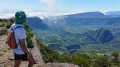
(1) At the first junction, continue straight on along the Sentier des Foulées de la Fraise, which is well signposted. The path then crosses the Domaine Vidot picnic area before entering the Ravine des Cafres. There are some lovely views of Piton de la Ravine Blanche and Piton Hyacinthe. The path is narrow but well shaded on this almost flat section. You’ll soon reach the Domaine Vidot water catchment.

(2) Leave the fitness trail on your right, cross a stream and continue straight on. Tackle two or three hairpin bends then continue straight on at the next junction. At the road, turn right for a few metres.

(3) Turn left onto the first path. You’ll soon reach the pastures and will need to follow them for several kilometres. The path runs alongside a stream. A few tree trunks help you cross three muddy sections.

The path narrows in places and passes beneath beautiful eucalyptus trees. The views become increasingly sweeping as you climb through the vast meadows. Occasionally, the path descends slightly before tackling a short climb up a few steps, some of which are quite high. At times, if you look back, you can see the Piton de Mont-Vert. The path is paved for a very short stretch after a bend.

(4) The path then widens abruptly before turning into a track with a slightly gentler gradient. After a few minutes’ climb along the track, you’ll reach a beautiful strawberry field – please do not pick the strawberries !

(5) At the junction, continue straight on along a track and enjoy the lovely views towards La Mare. You’ll soon reach a gate.

(6) The walk ends here. It is possible to go even higher by taking the path on the left (see practical information). Return to the starting point via the same route (S/E).

Waypoints

  1. S/E : km 0 - alt. 652 m - Domaine Vidot
  2. 1 : km 0.09 - alt. 645 m - Turn right towards the gate
  3. 2 : km 0.81 - alt. 695 m - Domaine Vidot water catchment
  4. 3 : km 1.01 - alt. 722 m - Take the path on the left
  5. 4 : km 2.7 - alt. 909 m - Start of the track
  6. 5 : km 3.4 - alt. 996 m - Strawberry field, continue straight ahead
  7. 6 : km 3.68 - alt. 1,017 m - Barrier, turn back
  8. S/E : km 7.36 - alt. 652 m - Domaine Vidot

Notes

Do not enter the strawberry field at (5)
- Toilets, tables and kiosks at Domaine Vidot (S/E)
- Option to continue to La Mare by taking the path on the left at (6) and then, from La Mare, head up towards Notre Dame de la Paix

Worth a visit

Places of interest:
- The Domaine Vidot water catchment (2)
- Domaine Vidot (S/E)
- The strawberry field at (5)

Enjoy the various panoramic views.

Reviews and comments

4.1 / 5
Based on 6 reviews

Reliability of the description
4.5 / 5
Ease of following the route
4.3 / 5
Route interest
3.5 / 5
User 22334101

Overall rating : 3 / 5

Date of your route : Sep 15, 2025
Reliability of the description : ★★★☆☆ Average
Ease of following the route : ★★★☆☆ Average
Route interest : ★★★☆☆ Average
Very busy route : No

As part of the route is unmarked, we ended up walking along the ravine at one point and missed the right path. Markings would be welcome.

Machine-translated

DavidBoissy
DavidBoissy

Overall rating : 4.7 / 5

Date of your route : May 14, 2024
Reliability of the description : ★★★★★ Very good
Ease of following the route : ★★★★★ Very good
Route interest : ★★★★☆ Good
Very busy route : No

It’s a shame; the path isn’t well maintained, so it’s not possible to walk all the way to the end. It wouldn’t take much to get it back in good condition.

Machine-translated

Kty974
Kty974

Overall rating : 4.3 / 5

Date of your route : May 06, 2024
Reliability of the description : ★★★★★ Very good
Ease of following the route : ★★★★★ Very good
Route interest : ★★★☆☆ Average
Very busy route : No

A walk that could be very pleasant if the path were maintained.
Beautiful views, no particular difficulties apart from the fallen trees on the path.
The route is well marked. We’ll do it again

Machine-translated

C.R.C.
C.R.C.

Overall rating : 3.3 / 5

Date of your route : Nov 20, 2023
Reliability of the description : ★★★★☆ Good
Ease of following the route : ★★★☆☆ Average
Route interest : ★★★☆☆ Average
Very busy route : No

There are some lovely views at certain points along the walk. A pleasant scent of strawberries greets you as you reach the end (before heading back down).
Be careful not to go the wrong way at the square where the barbecue is located: take the steps on the right as you go up, follow the road to the right for about a hundred metres, then turn left onto the Strawberry Trail.
On the way back, at the same spot on the square, make sure to turn right and cross the ford, otherwise you’ll end up turning back without realising it.
Be careful, it can be slippery at this time of year.

Machine-translated

Daniel Cadet
Daniel Cadet

Overall rating : 5 / 5

Date of your route : Nov 18, 2019
Reliability of the description : ★★★★★ Very good
Ease of following the route : ★★★★★ Very good
Route interest : ★★★★★ Very good

A really lovely walk, with stunning views, a top-notch description and a route that sticks to the map.
I decided to carry on further up the route of the long-distance hike I’m planning to do soon (my own long-distance hike).

Machine-translated

Orando974
Orando974 ★

Hello Fabrice79,

Thank you for your feedback; I’ll classify the hike as intermediate then!

Happy hiking,

Orando974

Machine-translated

Fabrice79
Fabrice79

Overall rating : 4.3 / 5

Date of your route : Nov 13, 2018
Reliability of the description : ★★★★★ Very good
Ease of following the route : ★★★★★ Very good
Route interest : ★★★☆☆ Average

A moderately easy route; the path can be slippery after rain,
The route is well marked
Beautiful view

Machine-translated

Other walks in the area

For more walks, use our search engine .

The GPS track and description are the property of this route's author. Please do not copy them without permission.