


 Country:

 City:
City:


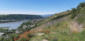
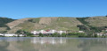
Start from the Espace Saint-Germain car park.
(S/E) Leave the Espace Saint-Germain via the pedestrian gate to the left of the restaurant and the hairdresser’s to reach Rue Vimaine. Follow it to the left as far as no. 74, where you’ll find the start of Rue Abbé Cales on the right. Follow this road to join the ViaRhôna.
(1) Turn left, go round the roundabout and cross the A-road to continue on the ViaRhôna alongside the River Rhône. Carry on to the dam.
(2) Cross the dam, ignore the dirt track on the right and turn right at the next junction. Continue past the business park until you reach the next junction.
(3) Turn left; at the T-junction by the greenhouses, turn left, then right, and go under the railway line. Cross the road and continue straight ahead along Chemin de la Viallère until you reach thesecond three-way junction just after house no. 7.
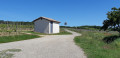
(4) Turn left and continue along Chemin de la Viallère, ignoring the paths on either side. Stay on the tarmac until you reach a small cottage on the left.
(5) Turn left and continue straight up the hill, joining the Lacat and reaching the Route du Grisard.
(6) Turn left, pass through a wooded area and, once you’ve come out the other side, take a path on the right. Continue along this path. After a descent, you’ll reach the Vézérance. Cross it and take the path that goes uphill. Keep going uphill, ignoring any paths on the right or those leading downhill. Then carry on along the Chemin du Bataillard and continue until you reach the Route de Rive-de-Gier.
(7) Turn left, cross Les Amaris and follow the road (D502) for 1.5 km until you reach the junction with the D138 (Saint-Cyr-sur-le-Rhône) on the left and a car park on the right.
(8) Head towards the car park and take the path on the right. Carry on straight ahead until you reach the corner of the field.
(9) Turn sharply right, follow the track which curves widely to the left before reaching some pylons. Then continue straight on along this track until you reach the tarmac at the Croix du Pont junction (small wayside cross on the right-hand side).
(10) Turn right and head downhill to the Stop sign.
(11) Take a hairpin bend to the left, towards Guigual. At the next junction, leave the road and follow Chemin Guigual (dead end) straight ahead (marked with white and brown signs). Walk past the hamlet on your right and you’ll come to a sharp bend to the right.
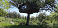
(12) Continue along the track to the left (marked with white and brown signs) and head downhill to the fork just after the power line. You’ll notice a treehouse.
(13) Turn sharply right and continue downhill. Pass a hairpin bend to the left, go under the power line again and reach the Ruisseau des Côtes before heading back up to the hamlet of Chaumartin.
(14) Do not enter the hamlet but follow a descending path that runs alongside the houses on the left. This then turns into a steep track. Watch out for fallen trees and your speed, as the track is tricky! Join the D386.
(15) Turn right, enter Saint-Romain-en-Gal, then take the first street on the left, Chemin de la Lone. Pass under the railway line and immediately join the ViaRhôna.
(16) Carry on to the right and follow the River Rhône.
(17) Pass the confluence of the Rhône and Sévenne rivers and continue to Sainte-Colombe. You’ll soon spot a square on the right lined with plane trees. Turn right just before it, onto Rue du 19 Mars 1962, at the foot of an old square tower. At the top, carry on to the left, then take a right-left turn onto Rue Cochard. Take care: this is a one-way street for cars, and traffic is coming from the opposite direction. At the end, turn left onto Rue Paul Doumer and head for the footbridge over the Rhône.
(18) Cross the Rhône then turn right immediately. Cross the road just after the roundabout, then continue to the right along Quai Riondet until you find the street on the left leading towards the Espace Saint-Germain and the Veterinary Clinic, Rue Denfert Rochereau.
(19) Follow this street, cross Rue Vimaine, then turn right straight away into Espace Saint-Germain (S/E).

 Visorando Member
 Easy
Easy 
 Local authority
 Moderate
