Circular Lac du Lauzon tour via the Col de la Rousse

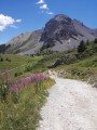
A lovely circular route that takes you from one valley to another – from the Lac de Lauzon valley, which starts at Coin, to the Chalets de Clapeyto valley, via a little-known and fairly steep pass.

Details

n°3502872
Creation:
Last update:
Last review:
  • Walking
    Activity: Walking
  • ↔
    Distance: 7.50 mi
  • ◔
    Average duration: 6h 00 
  • ▲
    Difficulty: Difficult

  • ⚐
    Back to start: Yes
  • ↗
    Ascent: + 2,881 ft
  • ↘
    Descent: - 2,884 ft

  • ▲
    Highest point: 8,238 ft
  • ▼
    Lowest point: 5,689 ft

Description of the walk

Park near the small bridge just before the Brunissard cross-country ski car park.

(S/E) Cross the stream and follow it as closely as possible heading south.

(1) The path joins theGRP® 58. Follow it for 3 km, continuing to climb.

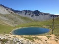
(2) Continue on level ground, leaving theGRP® 58 which heads back down, and carry on climbing, passing close to the Cabane de la Gardère. Continue to Lac du Lauzon (yellow markings).

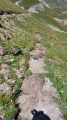
(3) At the lake, take a small, poorly marked path (cairns) which climbs steeply to the Col de la Rousse.

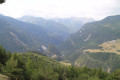
(4) Descend towards the Clapeyto valley, staying in the small valley closest to the mountain.

(5) Take the path on the right which climbs back up to the Col du Cros.

(6) Head back down towards Brunissard along a lovely path. Please note: the path for thesecond part of the descent has been altered and no longer crosses a large scree slope but arrives further west (marked in yellow).

(7) Turn right onto the “discovery trail”, which crosses the ski runs and leads back to the bridge by following the river (S/E).

Waypoints

  1. S/E : mi 0 - alt. 5,846 ft - Car park near a small bridge
  2. 1 : mi 0.36 - alt. 5,696 ft - Junction with GRP 58
  3. 2 : mi 1.83 - alt. 5,833 ft - Path leading uphill
  4. 3 : mi 3.56 - alt. 7,487 ft - Lac du Lauzon (2283m)
  5. 4 : mi 4 - alt. 8,238 ft - Col de la Rousse (2515m)
  6. 5 : mi 4.94 - alt. 7,297 ft - Turn right towards the Col de Cros
  7. 6 : mi 5.52 - alt. 7,549 ft - Col du Cros
  8. 7 : mi 6.88 - alt. 6,010 ft - Discovery Trail
  9. S/E : mi 7.5 - alt. 5,843 ft - Car park near a small bridge

Notes

I’ve marked it as difficult because of the climb up the Col de la Rousse, a steep and poorly marked path.
Fountain by the lake.
Wear good walking boots and use walking poles for the climb up to the Col de la Rousse.

Worth a visit

You pass quite close to Les Chalets de Clapeyto.

Reviews and comments

5 / 5
Based on 1 review

Reliability of the description
5 / 5
Ease of following the route
5 / 5
Route interest
5 / 5
totolitoto
totolitoto

Overall rating : 5 / 5

Date of your route : Aug 05, 2024
Reliability of the description : ★★★★★ Very good
Ease of following the route : ★★★★★ Very good
Route interest : ★★★★★ Very good
Very busy route : No

We did a slightly different route, parking at Le Coin and heading via the Lauzon and Neal passes to take in the views. It’s a bit longer (about 19 km in under 6 hours, not including a lunch break) but it’s well worth it. Plus, it gives you the chance to explore the Clapeyto area…

Machine-translated

Other walks in the area

For more walks, use our search engine .

The GPS track and description are the property of this route's author. Please do not copy them without permission.