Country:

 City:
City:




Starting point: car park at the municipal swimming pool in Saint-Étienne-Cantalès.
(S/E) Walk downhill and past the swimming pool. Turn left (south) onto the ‘Tour du Lac’ path, which is covered in white gravel. Follow the lakeside for 500 m.
(1) Head up towards the road (D18). Turn right onto it (a white gravel track) until you reach a junction with a bus shelter and rubbish bins.
Green signposting
(2) Turn sharply left. Ignore the tarmac road heading towards Le Puech (a dead end) but, a few metres further on, take the dirt track running parallel to it. Green signposting + Way of St James (scallop shell). Continue for 1 km on level ground. Pass under the power lines until you reach a tarmac road.
(3) Cross this road and continue straight on along the dirt track, going downhill. At the main road (D18), turn sharply right and follow the road for 400 m to the hamlet of Puech Mégerie.
(4) Turn right onto an uphill dirt track. Pass over the railway line. At the hamlet of Batitan, the track becomes tarmac. Continue to the D653. Here you temporarily leave the green signposting.
Double green line markings
(5) Cross the D653 and take a road in the housing estate almost directly opposite, marked with double green lines. 100 m further on, turn left onto a path between houses and fields. At the end of this, follow the road to the right, then take the first left. At a petrol station, rejoin the D653. Here you’ll rejoin the green markings.
Green signposting
Follow the D653 to the right until you reach Rue Émile Dumas.
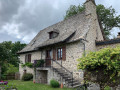
(6) Turn diagonally right onto this street. Shortly after the post office, turn right into a street that joins Rue Damont. Walk through medieval Laroquebrou to Maison Buc (27 Rue Damont), a beautiful medieval house.
Unmarked
(7). Take the narrow, steep staircase on the right, which runs alongside Maison Buc on its left. At the top, follow the street to the left (Chemin du Bousquet), which becomes a hillside path. Climb up to the castle via a street and then a flight of steps. Views of the Virgin Mary statue and the castle. Go back down the steps on the other side to reach another part of the medieval town. Walk down to the banks of the River Cère.
(8) Follow the river to the left (upstream), pass under the bridge and turn left onto the Place du Foirail. ‘Official’ sign marking the start of the green-marked ‘La Roquaise’ trail.
Green trail
(9) Head up towards the main avenue, turn left onto it, past the church and the square (with a beautiful old fountain). Turn left onto the street that crosses the bridge over the Cère. On the opposite bank (left), there is a pretty fountain. Take the road to the right, towards “Siran”, as far as the level crossing.
(10) Cross the level crossing, then immediately take the road on the left, signposted “La Barthe” (whilst the Way of St James continues straight on). 400 m further on, at a White Cross, take a dirt track leading uphill to the right. Continue for about 300 m.
(11) Turn left following the green signposting. Continue straight on for 1 km.
(12) Keep left on level ground until you reach a crossroads with two large, isolated fir trees.
(13) At this junction, carry on straight ahead along a tarmac road. Beautiful views of the Monts du Cantal: from left to right: Puy Violent (pyramid-shaped), Cabrespine (massive), Puy Mary (flat summit), Puy de Peyre Arse (rock), Puy Griou (pyramid-shaped), Plomb du Cantal (dome). Carry on to the left, passing under a power line and then past an aerial, before reaching the hamlet of Maroncle (an old farmhouse and a tower).
(14) Continue along a dirt track to the left. Shortly afterwards, you’ll come to an isolated grave. Views of the Monts du Cantal. You’ll emerge onto the D7.
(15) Cross the road and carry on straight ahead along a dirt track below on the right-hand side. 200 m further on, cross another road (D207). Take the tarmac road towards “Saint-Gérons (Bourg)”. Pass through the hamlet of Imbert and arrive at the cemetery in Saint-Gérons (water tap).
(16). In the village of Saint-Gérons, the road bends to the right. Follow it to the edge of the village.
(17) On leaving Saint-Gérons, turn left onto the road towards “Saint-Étienne-Cantalès” and cross the dam.
(18) Immediately after the dam, at the ‘Rue Aster’ sign, turn right onto the Chemin du Tour du Lac.
No signposting
Continue along the Chemin du Tour du Lac, which is covered in white gravel, until you reach the car park for the municipal swimming pool (S/E).

 Visorando Member
 Easy
Easy