


 Country:
 City:
City:



The easiest and quickest option is to park your car on the outskirts of the village of Stattmatten, at the junction of Rue principale and Rue de la Moder. Please note that these two streets also intersect within the village. Parking is available either:
- along the road at the end of Rue principale,
- at the junction, near the entrance to the fields,
- between the bridge and the information sign for the botanical trail, on the left-hand side,
Access by train is possible from Sessenheim station, but this adds 3.4 km to the route (there and back)
(S/E) Cross the bridge over the Moder and you will immediately come to a junction with an information board for the botanical trail.
(1) Take the path to the left of the information sign (marked with a Blue Saltire). Stay on the path, which runs alongside the River Moder, until you reach the edge of the forest. After 1.1 km, cross a small bridge and the path turns into a dirt track as you approach the edge of the forest. Stay on this track, which is surrounded by meadows, and at the first junction, keep left.
(2) At the junction, turn left and cross the bridge over the river to reach the village of Auenheim.
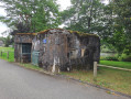
(3) On the other side, take the first street on the right, with a blockhouse on your right. Carry on straight ahead for about 150 metres until you reach the fishing boat decorated with seasonal flowers on your right.
(4) Two options:
- Carry on straight ahead along Rue de la Moder, a tarmac road, until you reach the edge of the village, about 450 m away.
- As shown on the map, take the path on the right which leads downhill and, immediately on your left, the grassy track between the houses and the woods, as far as the last house. Head back up the meadow on your left to rejoin Rue de la Moder (which you left just before), and turn right until you reach the end of the village.
(5) Carry on straight ahead along the forest track (marked with a Blue Saltire sign). At the next two T-junctions, go straight on, keeping the river on your right and the fields on your left.
(6) At the next junction, turn right and, at the T-junction, turn left. At the next junction, turn right to head towards the Moder. Then stay on the dirt track alongside the River Moder (on your right) and ignore all the paths on the left until you reach the D319 road (ruins of Fort d’Alsace on the left).
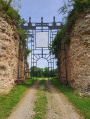
(7) Cross the road, follow it to the right and take the bridge over the Moder. Follow the D319 until you reach the entrance to the ruins of Fort Carré, which is on your left, 500 m away.
(8) Walk straight across the inner courtyard to the tunnel on the north side; go through the tunnel to reach the outside of the ramparts. Turn right to walk round the ramparts to the east, so as to return to the D319.
(9) Turn left and follow the poplar-lined avenue to the church in the centre of the village of Fort-Louis.
(10) Continue left towards the Rhine, then take the second street on the right – still heading towards the Rhine – until you reach the village boundary. Leave the D319 and turn diagonally right onto Rue de Stattmatten. At a Fork in the road, turn right onto a dirt track lined with poplars. On your left are small private ponds and, at the end of the track, an active gravel pit.
(11) Turn left and go round the gravel pit until you reach a tarmac road: in front of you is the Rhine embankment. Turn right and take the first bridge on the left. Walk up the embankment to reach the banks of the Rhine and the Port of Fort-Louis.
(12) Turn right onto the embankment, follow the river and pass under the first conveyor belt used for loading barges. Before the second conveyor belt, head back down a dirt track on your right. Cross the bridge and immediately turn right onto the tarmac road. Immediately head back up the tarmac track on your left.
(13) Turn left and leave the entrance to the gravel pit on your right. After 350 m, take the dirt track on the right which leads into a wood. Shortly afterwards, leave the wood and stay on the edge of it, with fields on your left.
(14) At the junction, turn left, staying on the dirt track. Carry straight on between the fields and ignore the side paths. Walk alongside the woods on your left until you reach a junction.
(15) Then turn left and enter the forest. You’ll soon come out onto a tarmac road; follow it to the right and you’ll quickly reach a junction you passed at the very start of the walk.
(1) Turn left, cross the bridge and you’ll immediately reach the car park (S/E).

 Visorando Member
 Easy
Easy 

 Tourist office


 Difficult
