The Croix de Virine circular walk starting from Lamerey

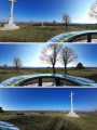
The walk is signposted along almost its entire route, passing by the Croix de Virine and offering a 360° panoramic view.

Details

19921464
Creation:
Last update:
Last review:
  • Walking
    Activity: Walking
  • ↔
    Distance: 10.94 mi
  • ◔
    Average duration: 5h 50 
  • ▲
    Difficulty: Moderate

  • ⚐
    Back to start: Yes
  • ↗
    Ascent: + 958 ft
  • ↘
    Descent: - 958 ft

  • ▲
    Highest point: 1,522 ft
  • ▼
    Lowest point: 988 ft
  • ⚐ Country: France
  • ⚐ City: Madonne-et-Lamerey (88270)
  • ⚑
    Start/End: N 48.221652° / E 6.238133°
  • Accessible from the train station Gare de Lamerey.
  • ❏
    IGN map(s): Ref. 3417E, 3417O, 3418O, 3518OT
  • Hour-by-hour weather

Photos

Description of the walk

Park at the junction of the D266 and Rue du Haut Fays in Lamerey.

(S/E) Take this street to leave the village of Lamerey, following the Green Disc and Red Ring signposts. Continue along Chemin de Bouzemont until you reach a junction.

(1). Turn right, then, about a hundred metres further on, turn left, keeping to the signposts. You’ll reach the crossroads at the hamlet known as La Voie Saint-Pierre.

(2) Leave the Green Disc markings and turn right onto the path marked with Red Discs towards the Croix de Virine. Leave the forest and you will then reach another Y-junction.

(3) Take the path on the right, passing between the fields on your right, until you reach the old gypsum quarry. Once past the quarry, the path descends back into the forest. Follow it to the junction with the D39 road leading to Circourt.

(4) Cross the road and continue along the path towards the Croix de Virine until the Yellow Disc and Red Disc signposts diverge.

(5) Keep to the right, following the Red Disc markings as you leave the forest. Walk alongside an orchard and begin the climb to quickly reach the Croix de Virine and its orientation table.

(6) Return to the previous junction, following the opposite direction to your outward journey.

(5) Take the path on the right, marked with a Yellow Disc, towards Circout. Leave the forest and continue along a road to reach the village of Circourt.

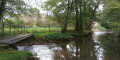
(7) Turn left towards the church, cross a bridge over the Robert and, once you have passed the church on your left, leave the Yellow Disc signposting behind to turn right onto the village’s main road, the D39. Carry on until you reach a farm on your right, then a Y-junction.

(8) Leave the road and veer left, following the Red Disc signposting.

(9) Leave the Red Disc signposting and follow the Red Ring signposting, continuing straight ahead. Take a gentle bend to the left, then enter the woodland again. You’ll come to a crossroads of footpaths.

Here you’ll find a Red Ring signpost; follow it to the right, then quickly turn left at the Saint-Bozon marker. Walk through the Bois de Haut Fays. Continue on until you reach a forest track at a barrier.

(10) Turn left onto it, then, a few hundred metres further on, leave it and turn right between two patches of woodland. Continue to follow the Red Ring markings. You will then reach Rue de la Corvée at the entrance to Lamerey.

(11) Turn left onto this street and head down towards the village centre and the car park (S/E).

Waypoints

  1. S/E : mi 0 - alt. 988 ft - Car park, Rue du Haut Fays - Gare de Lamerey
  2. 1 : mi 1.14 - alt. 1,076 ft - Chemin de Bouzemont junction
  3. 2 : mi 2.21 - alt. 1,266 ft - The Voie Saint-Pierre
  4. 3 : mi 2.82 - alt. 1,322 ft - Y-junction
  5. 4 : mi 3.84 - alt. 1,250 ft - D39 road
  6. 5 : mi 4.5 - alt. 1,394 ft - Crossroads
  7. 6 : mi 4.76 - alt. 1,522 ft - Croix de Virine
  8. 7 : mi 6.09 - alt. 1,066 ft - Circourt
  9. 8 : mi 6.57 - alt. 1,076 ft - Path
  10. 9 : mi 7.71 - alt. 1,339 ft - Bois du Haut Fays
  11. 10 : mi 9.41 - alt. 1,096 ft - Forest track – barrier
  12. 11 : mi 10.64 - alt. 1,024 ft - Rue de la Corvée. Near the - Gitte (rivière)
  13. S/E : mi 10.94 - alt. 988 ft - Car park, Rue du Haut Fays - Gare de Lamerey

Worth a visit

(S/E) Visit the General Leclerc monument, 500 metres from the start of the walk, where you’ll find the tank ‘Le Corse’.
(3) Once on the road, a sign indicates the location of the Saumeurs spring. I couldn’t find it during my walk; this detour is of no interest to me.

Reviews and comments

4.8 / 5
Based on 3 reviews

Reliability of the description
4.7 / 5
Ease of following the route
4.7 / 5
Route interest
5 / 5
Mrik
Mrik

Overall rating : 5 / 5

Date of your route : Aug 02, 2026
Reliability of the description : ★★★★★ Very good
Ease of following the route : ★★★★★ Very good
Route interest : ★★★★★ Very good
Very busy route : No

A brilliant walk in 35-degree heat, with about 75 per cent in the shade, so it was perfect.
A very pleasant trail and a magnificent view from the orientation point.

Machine-translated

Vogepat
Vogepat

Overall rating : 4.3 / 5

Date of your route : Apr 08, 2024
Reliability of the description : ★★★★☆ Good
Ease of following the route : ★★★★☆ Good
Route interest : ★★★★★ Very good
Very busy route : No

A very pleasant walk through woods, fields and villages. It’s worth checking out an alternative route through Circourt to avoid the tarmac.
I walked the route in the opposite direction; the ‘Club Vosgien’ route has been altered at the start, which was in fact my finish point
From the Virine cross, there’s a stunning 360° panoramic view.

Machine-translated

franchie
franchie

Overall rating : 5 / 5

Date of your route : Apr 12, 2022
Reliability of the description : ★★★★★ Very good
Ease of following the route : ★★★★★ Very good
Route interest : ★★★★★ Very good
Very busy route : No

A lovely walk through varied countryside.

Machine-translated

Other walks in the area

For more walks, use our search engine .

The GPS track and description are the property of this route's author. Please do not copy them without permission.