The Enchanted Walk from Belval-sous-Châtillon

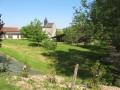
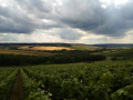
This short walk through woods and vineyards is organised by “La Marne à pied”. It will allow you to visit charming villages and enjoy some lovely views.

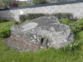
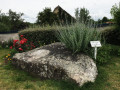
Don’t miss the Neolithic grinding stone at Belval-sous-Châtillon, just a few metres from the start.

Details

254039
Creation:
Last update:
Last review:
  • Walking
    Activity: Walking
  • ↔
    Distance: 6.88 mi
  • ◔
    Average duration: 3h 50 
  • ▲
    Difficulty: Moderate

  • ⚐
    Back to start: Yes
  • ↗
    Ascent: + 797 ft
  • ↘
    Descent: - 778 ft

  • ▲
    Highest point: 807 ft
  • ▼
    Lowest point: 410 ft

Photos

Description of the walk

(S/E) The route starts from the car park at the Belval-sous-Châtillon cemetery, at 51 Grande Rue. Walk a few metres towards the town hall, then turn left onto the Chemin de la Butte. Continue in the same direction through woods and fields. Please note that the path crossing the field is sometimes ploughed. When you reach the small road, at the corner of the motocross track, turn right. The path passes through a wooded area.

(1) Take the first track suitable for vehicles on the right. The track reaches the vineyards and runs alongside them at the top of the hill.

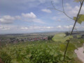
(2) Pass the Croix du Balai, a wayside cross offering a lovely view. Continue in the same direction to the village of Cuchery.

(3) At the crossroads, turn right onto Rue du Pressoir. When you reach Grande Rue, turn right and then right again onto Rue de la Gayette. Walk until you reach a Fork in the road.

(4) Turn left onto Chemin du Moulin Brûlé. Cross the stream and continue straight on towards the vineyards.

(5) At the vineyards, carry on straight ahead, ignoring the paths to the right and left. Cross the road (D24) and continue straight ahead along the vineyard.

(6) At the T-junction, turn left along the vineyard. The path zigzags through the vines. Turn right, then left, then right until you reach a small road.

(7) At the road, as you leave the vineyards, turn right and walk along this tree-lined road.

(8) At the T-junction, turn right towards the village. Walk to the church at La Neuville-aux-Larris, which is surrounded by sheep pastures.

(9) From the church, cross the large square (car park) and take Rue du Paradis. Walk past the cemetery. Continue in the same direction. Stay on this path through the woods and vineyards and walk to the hamlet of Paradis. Walk through the hamlet without changing direction, until you reach a hairpin bend.

(10) Take the path that branches off to the left at the bend. It runs alongside the vineyards, then crosses a stream and cuts through the fields. Walk on until you reach the vineyards.

(11) When you reach the vineyards, turn left and take the path that runs alongside them up the hill. Walk to the hamlet of La Poterne.

(12) 150 m after the first houses, turn right. Cross the stream and continue to the car park at the cemetery in the village of Belval-sous-Châtillon (S/E).

Waypoints

  1. S/E : mi 0 - alt. 594 ft - Car park at the Belval-sous-Châtillon cemetery
  2. 1 : mi 0.87 - alt. 725 ft - Path on the right
  3. 2 : mi 1.72 - alt. 712 ft - La Croix du Balai (viewpoint)
  4. 3 : mi 2.15 - alt. 456 ft - The village of Cuchery
  5. 4 : mi 2.37 - alt. 443 ft - Path on the left
  6. 5 : mi 2.87 - alt. 489 ft - Vineyards
  7. 6 : mi 3.15 - alt. 748 ft - Edge of the vineyards
  8. 7 : mi 3.34 - alt. 755 ft - Exit from the vineyards
  9. 8 : mi 3.54 - alt. 804 ft - T-junction
  10. 9 : mi 3.73 - alt. 804 ft - Church of La Neuville-aux-Larris
  11. 10 : mi 4.97 - alt. 692 ft - Start of the trail
  12. 11 : mi 5.55 - alt. 640 ft - Edge of the vineyards
  13. 12 : mi 6.35 - alt. 801 ft - La Poterne
  14. S/E : mi 6.88 - alt. 594 ft - Car park at the Belval-sous-Châtillon cemetery

Notes

Water is readily available in the cemeteries of the villages you pass through. There’s a lovely picnic area in Paradis.

Be sure to take the map and the app with you, as the signposts may have disappeared.

During very wet periods, the woods can be difficult to navigate.

Worth a visit

A Neolithic polishing stone lies 50 metres from the start of the walk.

The Belval polishing stone is a block of very hard rock dating from prehistoric times, used to polish flint axes. The often-parallel striations seen on the surface of these monuments are the result of repeated polishing of tool edges. The often-oval-shaped hollows, meanwhile, are the result of sharpening the cutting edges.

Winegrowers in every village, Champagne tastings and direct sales.

Reviews and comments

4.8 / 5
Based on 2 reviews

Reliability of the description
5 / 5
Ease of following the route
5 / 5
Route interest
4.5 / 5
virgule
virgule

It would appear that this walk has been recognised by the Union.

Machine-translated

Pascal Denis 51
Pascal Denis 51

Overall rating : 4.7 / 5

Date of your route : Mar 25, 2021
Reliability of the description : ★★★★★ Very good
Ease of following the route : ★★★★★ Very good
Route interest : ★★★★☆ Good
Very busy route : No

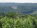
A lovely walk offering alternating views of vineyards and forests.

Machine-translated

virgule
virgule

A tip for dealing with black ice: an old, worn-out pair of socks that you slip on over your shoes. That way, you won’t slip at all.

Machine-translated

maxvalet
maxvalet

Hello,

It’s true – with the app, you have no trouble finding your way.
The ground was frozen, so I didn’t realise how much mud there was.
However, the concrete vineyard paths are very slippery when it’s freezing!

Machine-translated

virgule
virgule

Thanks for the info, I’ll update my guide.

With the app, actually, you don’t need signposts.

Are the paths too muddy?

Machine-translated

maxvalet
maxvalet

Overall rating : 5 / 5

Date of your route : Jan 27, 2021
Reliability of the description : ★★★★★ Very good
Ease of following the route : ★★★★★ Very good
Route interest : ★★★★★ Very good
Very busy route : No

PLEASE NOTE:
The yellow markings have been worn away in 90 per cent of cases!!!!!!
Otherwise, this is a walk that takes you through lots of very pretty scenery.

Machine-translated

virgule
virgule
• Edited:

Hello,

could you please include a link to the other route?

As mentioned above and in the description, I didn’t create the route myself; it’s provided by ‘La Marne à pied’. I’ve simply written the guide, as the maps usually made available to the public don’t include any explanations.

Machine-translated

anteli
anteli

This walk is actually called ‘La Croix du Balai’
I think it’s a shame that people can simply take it on by changing its name and starting point

Machine-translated

virgule
virgule

Hi Sally

The Tiquet walk heads into the woods, in an area that’s been ravaged by loggers, where you’d get lost without the app, and it doesn’t go to the Croix du Balai, which is a must-see.

I’ve simply followed the route suggested by ‘La Marne à pied’.

In theory, when you suggest a route that’s similar to one already published, the software tells you so.

Love

Machine-translated

sally
sally
• Edited:

Hi Virgule,

This walk is practically the same as the one from La Neuville aux Larris to La Poterne – Belval via Chatillon… which is 11.17 km long…

The only difference is the starting point, that’s all!!!!!

Machine-translated

virgule
virgule

Thank you for the prompt approval

Machine-translated

Other walks in the area

For more walks, use our search engine .

The GPS track and description are the property of this route's author. Please do not copy them without permission.