Country:

 City:
City:


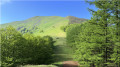
Park at the Col de Corrota (845 m) above Urepel.
(S/E) Head westwards up a faint but clearly visible path on the grassy slope leading to the summit of Ichterbegui (1,033 m): magnificent views beneath a sky bathed in beautiful light. Border marker 141 is located here: at this point, the border forms an angle; it does not follow the ridge line or any other feature of the terrain, but runs in a straight line between this point and the Lindus to the east.
(1) Descend due south along the ridge to rejoin the Camino a Urepel on the edge of the Pays Quint, passing over a pass that is unnamed on maps.
(2) The route continues until you reach the border of the Pays Quint further on, then a flat stretch.
(3) Carry on straight ahead to reach the Col d’Adipeko, where a sign stands: the majestic silhouette of the Adi then rises up before us.
(4) The climb to the right is steep, following the fence that runs along the ridge. Reach the summit of the Adi (1,456 m): a vast panorama over the peaks of the western Basque Country and beyond.
(5) After a brief pause at this viewpoint, walk about fifty metres along the summit ridge to reach Adiko Lepoa. Turn left (north-east) to follow a track running parallel to the fence, which descends along the ridge towards the Col d’Aratun (1,219 m), clearly visible below: there is a signpost.
(6) Continue straight on along the GR®11 – GR®12: this section of the route is now marked with repainted signposts and red and white posts. Cross a rocky, wooded hilltop, carefully following the clearly visible markings, and arrive at a signpost.
(7) Take the path on the right. You’ll emerge onto a meadow, which you should cross whilst keeping to the left of the fence, then climb the slope of Iturrumburu to reach the summit (1,338 m).
(8) Walk along the grassy ridge as it descends.
(9) Just after a rocky outcrop, don’t miss the fork to the left, marked by stones that are barely visible in the meadow. You’ll come out onto a wider path; follow it to the left to reach the only building (Etxamendiko etxola) in this wild watershed: you may wish to stop for a picnic here.
(10) Follow the GR®12 and return to the rocky outcrop you passed on the way out.
(7) Carry on to the Col d’Aratun.
(6) Keep to the right onto the GR®11, continuing to follow the track – still heading west – which leads to the pastures of Adiko Soroa, a megalithic site featuring several cromlechs.
(11) Pass a small fort, a remnant of the surveillance line (La línea P) erected by Franco’s army. The well-marked path leads back to the Col d’Adipeka (and the Pays Quint), where you rejoin the ascent route.
(4) Follow this route in the opposite direction, passing back over the small pass.
Continue to the right along the eastern flank of the Ichterbegui to reach boundary marker 142 (actually a boundary cross) carved into a rock by the side of the path.
(12) Then return to the Col de Korrota (S/E)
 Visorando Member
 Very difficult
 Moderate
  Tourist office
 Easy
Easy