Country:

 City:


Starting point: Wieden Tourist Information Centre (Kirchstraße 2, 79695 Wieden)
Parking: Car park in the centre of Wieden
Public transport: Get off at Wieden Ortsmitte
(S/E) There are various routes for this walk. We’ve opted to start at the Spitzdobelweg, which is near the school. From here, we follow the signposts via the Erbsengarten, then go straight on at the fork and continue to the Wieden district of Ungendwieden.
(1) From there, we head towards Lailehöhe. To do this, we turn left and then immediately right again; after about 700 metres, following a left-hand bend, we turn right onto a path. At the next crossroads, we take a sharp left towards Lailehöhe.
(2) We turn sharply right and come upon the beautiful panoramic path leading to the Knöpflesbrunnen.
(3) At the Hasbacher Höhe, we turn right and continue on to the Knöpflesbrunnen and the mountain inn of the same name.
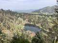
(4) From up here, we have a magnificent panoramic view of the Wiedener Valley, with the Belchen in the background. From the summit of the neighbouring Tannenharzfelsen viewpoint, you also have a fascinating view of the surrounding Black Forest peaks.
On the way back, we walk along the shorter Finstergrundweg, passing through the Graben district of Wieden.
(5) There, we turn left, then take the second right and follow the path to the hamlet of Säge.
(6) At the junction before the L123, take a sharp left, then cross the road and pass through Säge and Niedermatt, before turning left onto Kirchstraße back to the starting point (S/E).

 Association / Club / Walk leader

 Difficult

 Tourist office

 Visorando Member

 Easy

 Very difficult