Chartreuse State Forest

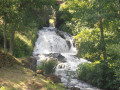
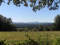
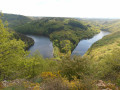
This is a lovely walk through the Sioule Valley, remarkable for its scenery and the diversity of its natural habitats. You’ll enjoy the beautiful Montfermy waterfall and the unobstructed views of the volcanoes of the Chaîne des Puys.

Details

24971448
Creation:
Last update:
Last review:
  • Walking
    Activity: Walking
  • ↔
    Distance: 9.87 mi
  • ◔
    Average duration: 5h 20 
  • ▲
    Difficulty: Moderate

  • ⚐
    Back to start: Yes
  • ↗
    Ascent: + 938 ft
  • ↘
    Descent: - 938 ft

  • ▲
    Highest point: 2,385 ft
  • ▼
    Lowest point: 1,696 ft

Photos

Description of the walk

On the Pontgibaud bypass (D941B) towards Pontaumur, take the D418 to Montfermy. Car park near the bridge over the Sioule.

(S/E) From the starting point sign, cross the Sioule and follow the D418 for about 400 m, then take thesecond road on the left towards La Garde.

(1) At the first bend, take a path leading down to the left, cross a stream, go up and then down again to follow the banks of the Sioule (waterfall on the left).

(2) Ignore a footbridge on the left and continue along the right bank until you reach a junction under a high-voltage power line (anotherPR® Vert sign).

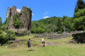
(3) Turn left and, 20 m further on, head down to the right. Continue along the banks of the Sioule until you reach the road (300 m to the right: ruins of the Port Sainte-Marie Charterhouse).

(4) Follow the road to the left and cross the Sioule.

(5) Head up to the right along the stony path. Join a road, leaving two paths on your right.

(6) Cross a road and continue straight ahead to the next road.

(7) At the crossroads, head straight on and follow the small road to a Fork in the road with a wooden cross.

(8) Turn left, pass through the hamlet of La Serre and, on the way out, take a good path straight ahead and continue to a four-way junction.

(9) Turn left, then ignore a path on the left and carry on to a crossroads near a hut. Turn right and continue to a road

(10) At the crossroads with a cross, turn left and arrive at the village of Côte-Faîte.

(11) Cross the village by heading right and, on the way out, go down the path on the right, then head back up through the woodland to a four-way junction.

(12) At the Fork in the road, head down to the left, then go back up and, at the next junction, carry on straight ahead. At the small road, continue straight on towards the hamlet of Chazots.

(13) In the hamlet, take a grassy path straight ahead, reach a T-junction and head down to the left to the Quarte stream.

(14) Cross it and continue down to the left. Cross the Ruisseau de Tourdoux and head back up the other side of the valley. At the junction of several paths, turn right for 20 m, then veer left and continue along this well-maintained path

(15) At the T-junction, turn right for 50 metres, then left onto the small road. After 150 metres, turn right, then left at the first Fork in the road, and continue downhill to Montfermy (view of the village and its 12th-century church) to reach the car park near the bridge over the Sioule (S/E).

Waypoints

  1. S/E : mi 0 - alt. 1,834 ft - Car park near the bridge over the Sioule
  2. 1 : mi 0.43 - alt. 1,932 ft - The Bend Trail
  3. 2 : mi 1.05 - alt. 1,801 ft - Waterfall - Sioule (la)
  4. 3 : mi 2.01 - alt. 1,821 ft - Crossing beneath a high-voltage power line
  5. 4 : mi 3.64 - alt. 1,726 ft - Near the ruins of the Port St-Marie Charterhouse
  6. 5 : mi 3.74 - alt. 1,713 ft - Path after crossing the Sioule
  7. 6 : mi 4.01 - alt. 1,900 ft - Road junction
  8. 7 : mi 4.29 - alt. 2,110 ft - Road junction
  9. 8 : mi 4.56 - alt. 2,175 ft - Wooden cross
  10. 9 : mi 4.95 - alt. 2,241 ft - Crossroads
  11. 10 : mi 5.76 - alt. 2,264 ft - Route de Côte Faite
  12. 11 : mi 5.89 - alt. 2,251 ft - Village of Côte Faîte
  13. 12 : mi 6.29 - alt. 2,247 ft - Crossroads of four paths
  14. 13 : mi 7.23 - alt. 2,297 ft - The hamlet of Chazots
  15. 14 : mi 7.65 - alt. 2,238 ft - La Quarte stream
  16. 15 : mi 8.86 - alt. 2,365 ft - T-junction
  17. S/E : mi 9.87 - alt. 1,834 ft - Car park near the bridge over the Sioule

Notes

For your safety, always take a bottle of water, a hat, warm and waterproof clothing with you, and wear suitable walking shoes.

Some sites are sensitive, so please stay on the marked paths. Avoid picking wild flowers and disturbing wildlife. Please take your rubbish with you.

Always be cautious and plan ahead when you're outdoors. Visorando and the author of this route cannot be held responsible for any accidents occurring on this route.

The GR® and PR® markings are the intellectual property of the Fédération Française de Randonnée Pédestre.

Reviews and comments

4.4 / 5
Based on 3 reviews

Reliability of the description
4.7 / 5
Ease of following the route
4.3 / 5
Route interest
4.3 / 5
ornon1112
ornon1112
• Edited:

Overall rating : 4.7 / 5

Date of your route : May 16, 2025
Reliability of the description : ★★★★★ Very good
Ease of following the route : ★★★★★ Very good
Route interest : ★★★★☆ Good
Very busy route : No

The first part of the route follows the Sioule; the second part is more rural and wooded (there are no notable views of the Chaîne des Puys).

Machine-translated

Catherine Manin
Catherine Manin

Overall rating : 4.3 / 5

Date of your route : Jul 02, 2023
Reliability of the description : ★★★★☆ Good
Ease of following the route : ★★★★☆ Good
Route interest : ★★★★★ Very good
Very busy route : No

A magnificent walk in the Combrailles. A landscape of shady woodland by the water’s edge.
The walk is easy.
Access to the ruins of La Chartreuse Port Sainte Marie is via a slight detour at point 4.
At this same point 4, this 16-km walk can be combined with the 7-km “Chartreuse Port Sainte Marie” walk, which starts in Tournobert (near Les Ancizes), to form a 23-km circular route.

Machine-translated

da cunha luis
da cunha luis

Overall rating : 4.3 / 5

Date of your route : Jun 26, 2023
Reliability of the description : ★★★★★ Very good
Ease of following the route : ★★★★☆ Good
Route interest : ★★★★☆ Good
Very busy route : No

A lovely walk

Machine-translated

Other walks in the area

For more walks, use our search engine .

The GPS track and description are the property of this route's author. Please do not copy them without permission.