Country:

 City:
City:



From les Carroz, catch the free navette bus up to Flaine and get off at the top of the funicular.
(S) Take the funicular down to the Flaine Forum, where you can appreciate (or not) the brutalist concrete architecture. Take the road to your right to arrive at a T-junction. Turn left and walk down the road to a curving path on the right which leads down to the main road. Turn left and walk along and down to where the road curves right and into the lower car park. Opposite you is a track leading to a télécabin station. (signpost Pré Michalet)
(1) Walk to the télécabin station, follow the track rightwards under the cables and then leftwards towards some trees and a signpost (Le Stade). Turn right onto a forest path and follow this to a further signpost (Le Torrent) where the path splits.
(2) Option: Both paths join again at another signpost (Cascade du Torrent).
Note: The left-hand path is easiest.
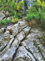
We took the right-hand path, where you have to scramble down some rocks via some metal staples and a chain to the edge of the ravine (see photo).
After this, the path leads to a further signpost (Le Circuit) and out of the trees to an open space on the left of the Déchèterie. Follow a wider track in a Westerly direction to a signpost (Cullorcy).
(3) Follow the path down into trees again to arrive at a bench where the path splits. Turn left and follow it with some steep sections down to more open ground and a signpost (Le Pied du Torrent). Turn right and follow the path around the grassy area to a track and signpost (Plaine du Lac). Turn left and follow the track past a few chalets (signpost Chalets de la Plaine (4)) and onwards to arrive at a junction where the paths split.
Option: You can take either path. You will arrive at the point where both paths rejoin.
The right-hand path goes up and into trees to follow the North bank of the lake.
The left-hand path cuts across the meadow to the South bank.
We chose to cross the meadow and follow the left bank.
(5) Turn left (or keep going straight if you chose to follow the North bank of the lake) and follow the path with shade from the trees to a signpost (Creux du Lavouet). Continue to a further signpost and split in the path with twin signposts (Col du Cou).
(6) Take the right-hand path to another signpost (Chalet du col) where you are going straight on (not uphill). Now contour around and ascend gently to an opening on the ridge, signpost (Téte du Chevet) and picnic bench.
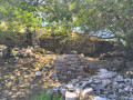
(7) Continue for 400m to a signpost and split in the path (Sur l'Écherre). Go straight on and into open meadow where there may be sheep grazing (electric fences). Look out on the left for a ruin and take the old track down to it. From the ruin, follow the path across the meadow and back to the path you were following originally. There is a signpost (Les Cordées). Turn left and walk downhill to a T-junction and signpost (Plaine Joux).
(8) Turn left and walk down 100m to another T-junction and signpost (La Charbotaz). Turn right and follow the road to cross a bridge; curve around to the left and follow the road which eventually runs parallel to and just below the road from Les Carroz to Flaine. Walk past a signpost (Pas á l'Áne Est) and picnic benches to a split in the path and signpost (Pas á l'Áne).
(9) Take the right-hand split. This leads to a bridge over the road and to a junction just left of a tight bend in the road signpost (Passerelle Pas á l'Áne).
(10) Turn left and take a track into the woods (take care: forestry work in summer 2026). Follow the track to emerge at the edge of a piste, turn left and walk down the left side of the piste to the téléski station. Walk past this and a restaurant to a residential road, and follow it as it curves down and into les Carroz.(E)
 Visorando Member
 Moderate
 Difficult