Manganu – Vergio Pass

Stage8, travelling from south to north. One of the quietest stages.

This walk is part of a multi-day hike: GR® 20 Sud Nord en 12 étapes

Details

79946
Creation:
Last update:
Last review:
  • Walking
    Activity: Walking
  • ↔
    Distance: 9.43 mi
  • ◔
    Average duration: 5h 45 
  • ▲
    Difficulty: Moderate

  • ⚐
    Back to start: No
  • ↗
    Ascent: + 1,588 ft
  • ↘
    Descent: - 2,267 ft

  • ▲
    Highest point: 6,181 ft
  • ▼
    Lowest point: 4,347 ft
  • ⚐ Country: France
  • ⚐ City: Orto (20125)
  • ⚑
    Start: N 42.219683° / E 8.980506°
  • ⚑
    End: N 42.286612° / E 8.892873°
  • ❏
    IGN map(s): Ref. 4150OT, 4151OT, 4250OT, 4250OTR, 4251OT, 4251OTR
  • Hour-by-hour weather

Description of the walk

(S) From the Manganu refuge, cross the river then take the path on the right heading north, which winds gently uphill to the Vaccaghia sheepfolds. From there, continue straight on, climbing steadily and without difficulty, until you can see the Inzecche sheepfolds on your right from a small pass.

(1) The signposting follows the new route which passes by these sheepfolds, but it is possible either to follow the old signposting (which has been greyed out) along the left bank of the stream, or to stay on the right bank but veer off before the sheepfolds, heading west.

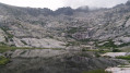
Follow the easy, almost flat path north-westwards until you reach the end of Lake Nino, then turn west-south-west.

(2) Begin the ascent and head for Bocca a Reta.

(3) The path then becomes rockier and follows the western slope of the ridge running alongside Serra San Tomaghiu.

(4) Cross the ridge to begin a series of short ascents and descents on the northern slope through low-lying woodland.

(5) Cross the ridge again to follow the western slope and reach Bocca San Pedru, with its oratory, its wind-blown trees and (frequently) its wild pigs.

(6) Begin the descent to the right, heading east-north-east, and pass a series of short hairpin bends.

(7) At the crossroads, turn left towards Vergio. The path then passes through a forest of oak and pine trees and follows the contour lines until, after a final short climb branching off from the circular path, it reaches the road to Castellu di Vergio, which is on the left (E).

Waypoints

  1. S : mi 0 - alt. 5,272 ft - Refuge de Manganu
  2. 1 : mi 2.76 - alt. 5,709 ft - Small pass - Bergeries des Inzecche
  3. 2 : mi 4.01 - alt. 5,814 ft - Lake Nino - Lac de Nino (Lake Nino)
  4. 3 : mi 4.62 - alt. 6,181 ft - Bocca â Reta
  5. 4 : mi 5.47 - alt. 5,830 ft - Crossing the Serra San Tomaghiu ridge
  6. 5 : mi 6.36 - alt. 5,226 ft - Ridge crossing
  7. 6 : mi 6.86 - alt. 4,777 ft - Bocca San Pedru
  8. 7 : mi 7.1 - alt. 4,491 ft - Crossroads; turn left
  9. E : mi 9.44 - alt. 4,606 ft - Hotel-Refuge du Col de Vergio

Notes

(E) At Castellu di Vergio, the campsite is frequented by foxes, which can be aggressive if startled or chased – keep your provisions safe, ideally up high.

Worth a visit

Shortly before (3), you’ll see the source of the Tavignano here.

Reviews and comments

5 / 5
Based on 2 reviews

Reliability of the description
5 / 5
Ease of following the route
5 / 5
Route interest
5 / 5
rage2001
rage2001

Overall rating : 5 / 5

Date of your route : Jun 30, 2026
Reliability of the description : ★★★★★ Very good
Ease of following the route : ★★★★★ Very good
Route interest : ★★★★★ Very good
Very busy route : No

This stage is one of the most accessible and least demanding on the GR 20, following a path that is often very easy to walk on and contains no high-mountain sections. The stretch past Lake Nino is undoubtedly one of the most beautiful!
The route guide and photos can be found here: https://treksrandos.fr/corse/gr-20-parti...

Machine-translated

Onlyjo
Onlyjo

Overall rating : 5 / 5

Date of your route : Jun 15, 2026
Reliability of the description : ★★★★★ Very good
Ease of following the route : ★★★★★ Very good
Route interest : ★★★★★ Very good
Very busy route : Yes

Some north-facing sections with snowfields require mountaineering crampons for added safety.
A fairly physically demanding route with a few technical sections
Section near Lake Nino

Machine-translated

Other walks in the area

For more walks, use our search engine .

The GPS track and description are the property of this route's author. Please do not copy them without permission.