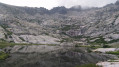
Lavu del’Oriente and Bergerie de Timozzu

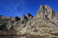
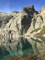
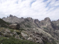
Those not interested in summits should at least make their way to the idyllic Lake Oriente. There, a fantastic, unrivalled high-mountain world opens up before us: grassy slopes, murmuring streams and, at times, glistening snowfields. Facing us is the summit of Monte Rotondo, the island’s second-highest peak at 2,622 metres.
In 1852, Ferdinand Gregorovius remarked that the view from the summit of Rotondo is far more magnificent than that from Mont Blanc.

Details

n°809601
Creation:
Last update:
Last review:
  • Walking
    Activity: Walking
  • ↔
    Distance: 6.06 mi
  • ◔
    Average duration: 6h 05 
  • ▲
    Difficulty: Difficult

  • ⚐
    Back to start: Yes
  • ↗
    Ascent: + 3,753 ft
  • ↘
    Descent: - 3,783 ft

  • ▲
    Highest point: 6,772 ft
  • ▼
    Lowest point: 3,058 ft

Photos

Description of the walk

Start from the Tragone Bridge on the D623, the Restonica Gorges road.

(S/E) Follow the road uphill to the Timozzu Bridge, then continue along the road a little further until you see a forest track branching off to the left, marked by a gate and a boulder bearing the inscription “Timozzu/Rotondu”.

(1) Follow this path for a short while until you reach a crossroads. Turn right and continue to the next crossroads before crossing the stream.

(2) Follow the path on the right, marked by cairns (red paint markings).

(3) After about 1 hour 15 minutes’ walk, turn left (south-south-east) and head up to the Timozzu sheepfolds.

(4) The ascent to Lac de l’Oriente begins on the right before you reach the sheepfold: there is a sign on the ground marked ‘Lac de l’Oriente’.

(5) The path heads south-west and climbs along the ridge.

(6) Cross the stream towards the Triggione Spring (altitude 1,921 m), just before a small waterfall. The path now climbs to the left, first eastwards then southwards, and leads to the shores of the Lavu Del’Oriente (Lac de l’Oriente).

(7) The return journey follows the same route, avoiding the detour via the Bergeries de Timozzu.

(5) Continue straight on (north-east).

(3) Carry on straight ahead (north-east).

(1) Follow the road to the right and head for the Tragone Bridge (S/E).

Waypoints

  1. S/E : mi 0 - alt. 3,091 ft - Tragone Bridge
  2. 1 : mi 0.43 - alt. 3,356 ft - Registration: Timozzu/Rotondu
  3. 2 : mi 0.77 - alt. 3,661 ft - Cairns, red paint markings
  4. 3 : mi 1.52 - alt. 4,928 ft - Junction: turn left
  5. 4 : mi 1.71 - alt. 4,974 ft - Timozzu sheepfolds
  6. 5 : mi 1.88 - alt. 5,052 ft - Turn left towards the south
  7. 6 : mi 2.66 - alt. 6,309 ft - Triggione Spring
  8. 7 : mi 3.17 - alt. 6,772 ft - Lavu Del’Oriente (Lake Oriente)
  9. S/E : mi 6.06 - alt. 3,091 ft - Tragone Bridge

Notes

Location: Corte, Restonica Valley.

Please note: arrive early in the morning, as there is limited parking.

A cairn is a man-made pile of stones used as a landmark in the hills or on rough terrain.

Make sure you’re kitted out with good walking boots and walking poles.
A windbreaker and waterproof trousers are essential, as the weather changes quickly in the mountains.
There is no water along the route.

It took us 7 hours and 3 minutes, including a 3-hour and 3-minute break, as the rain and mist made this hike difficult and slippery (this is high-altitude mountain terrain!!!) but absolutely splendid! Well worth doing again, if only for the beauty of the scenery.

GPX track recorded using a Twonav Sportiva 2 GPS

Worth a visit

Timozzu sheepfold. Cheese available to buy in season.

Reviews and comments

4.7 / 5
Based on 1 review

Reliability of the description
4 / 5
Ease of following the route
5 / 5
Route interest
5 / 5
Biquette13
Biquette13

Overall rating : 4.7 / 5

Date of your route : Sep 05, 2025
Reliability of the description : ★★★★☆ Good
Ease of following the route : ★★★★★ Very good
Route interest : ★★★★★ Very good
Very busy route : No

As the Restonica Valley is closed to cars at the start of the hike, I recommend taking the shuttle bus and then following the road (crossing the rivers at the destroyed bridges)
Otherwise, the description is good, with little risk of error.
The lake is small but the setting and view are superb.

Machine-translated

Gerefe
Gerefe

Since the storm in November 2023, the road ends at the Frasseta bridge. The footpath climbs up the left bank of the Restonica until it reaches a ford that allows you to cross the river. There are no signs to indicate where this is, and we tried to cross the torrent without success (too much water and too strong). We gave up...

Machine-translated

Terriccio
Terriccio

Hike completed on 14 August 2024.
Following the storm in November 2023, which washed away the road and bridge at Tragone, you should allow about 20 minutes extra to reach the start of the walk.
From the start to the sheepfolds, the path winds through a forest where the shade will be welcome.
Afterwards, from the sheepfolds to the lake, there is no shade. Make sure you take enough water with you; although you can cool off by wading through the streams along the way, there are no springs.

Machine-translated

Other walks in the area

For more walks, use our search engine .

The GPS track and description are the property of this route's author. Please do not copy them without permission.