Country:
 City:
City:


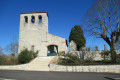
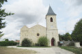
Car park near the church of Saint-Romain.
(S/E) From the car park on the north side of the church, turn your back on the church and take the grassy path which descends to the left of a small building; follow this path until you reach a road.
(1) At the junction with the D277 (Route des Tulipes), turn right then left onto the Route des Pigeonniers. Pass the houses in the hamlet of Jouantas and take the first stony track on the right until you reach the road.
(2) At the junction with the Chemin de Monflanquin, turn right, then cross the crossroads ( junction with the D277 – take care) and head straight on along the track towards the hamlet of Castillas.
Go round this house on the right, then take the road on the left.
(3) Follow the grassy track straight ahead, which leads onto a small road, the Romaintoise, and continue along it until you reach the Fork in the road a little further on.
(4) Turn left onto the small road leading towards Carossemiche and Ferréol. At the end of this road, take the grassy track (marked blue) and continue along it until you reach the next Fork in the road.
(5) At the junction with a signposted hiking trail on the right, carry on straight ahead along the grassy path marked with a Yellow Cross. Continue along this path, which becomes tarmac at a place called Galdou, and carry on downhill to the small pond.
(6) When you reach the pond, go round it to the right until you come out onto a road; turn right onto this road and follow it to the hamlet of Monplaisir.
(7) At the hamlet mentioned, turn left onto the road for 50 metres, then take the grassy path alongside the house. At the end of the stony track, leave Cap del Rat and then Chastelet on your left and continue along the tarmac road.
(8) At the junction, turn right onto the D248 towards Saint-Romain-le-Noble.
(9) At the crossroads, leave the road to Laspeyre on your left and La Romaintaise on your right; continue straight ahead to Saint-Romain-le-Noble and the starting point (S/E).


 Visorando Member

 Association / Club / Walk leader
 Easy
Easy