From the Bonnan Valley to the Combes d’Orsayrolles

A circular route starting from the heights of the Bonnan Valley and leading to the ‘land of the bear’ in Roussayrolles. The route alternates between wooded valleys and rocky Mediterranean plateaus.
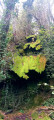
Along the way, walkers will come across a dolmen, the ruins of a Merovingian sarcophagus, a petrified waterfall and a beautiful church decorated by Nicolaï Greschny, one of the great masters of icon painting and frescoes.

Details

n°1647559
Creation:
Last update:
Last review:
  • Walking
    Activity: Walking
  • ↔
    Distance: 9.74 mi
  • ◔
    Average duration: 5h 30 
  • ▲
    Difficulty: Moderate

  • ⚐
    Back to start: Yes
  • ↗
    Ascent: + 1,161 ft
  • ↘
    Descent: - 1,171 ft

  • ▲
    Highest point: 1,398 ft
  • ▼
    Lowest point: 449 ft

Photos

Description of the walk

Park in the car park of the Milhars village hall.
Much of the route (the outward leg) is unmarked and requires a map and the use of a GPS.
The section marked in yellow, at the end of the route, forms part of the circular loop known as the Bonnan Valley.

Yellow markings – Vallée de Bonnan

(S/E) On the D600, with your back to the village hall, head left towards Place de la Mairie. In front of the community café, cross the road and head up to the right. This uphill street passes two wayside crosses. At the second white wrought-iron cross in Bournazel, carry on straight ahead, following the sign for the Bonnan Discovery Trail. After the bend, the road approaches the stream.

No signposting

(1) Stay on the road to cross the stream. Walk uphill alongside the stream. At the three-way junction, veer left. At the next junction, take a sharp left-hand bend. The road gives way to a dirt track at Darrasse. Pass a dovecote on your left.

(2) At the first junction, turn left and walk past the relay pylon. Keep heading generally south-west, ignoring the small paths branching off to the right and left. The path, which is initially narrow near the pylon, quickly widens into a stony track. The track you are following is the QRGA Inter-municipal Path. It climbs steadily, with a few flat sections to catch your breath, through varied countryside as it crosses the Pech Mas plateau, then narrows towards its final section before reaching a wide, unpaved forest road.

(3) At the white forest road, make a zigzag turn first left then right to follow a wide dirt track.

(4) Take the left-hand path signposted ‘Sentier Intercommunal’. This leads to a wide white track; follow it to the left. After about fifty metres, you’ll join theGRP® Cordes-Penne.

(5) Take theGRP® to the left. This is a wide forestry track winding through oak woodland. Walk for about 800 m until you reach a cairn marking a narrow, barely visible path branching off to the left.

(6) At the cairn, follow the small grassy path for a return trip to the Dolmen d’Orsayrolles.

(7) Retrace your steps back to the cairn.

(6) Take the track on the left again. When you come to a path coming from the right, carry on straight ahead. Pass Les Clavilières and reach a junction (elevation 426).

(8) Turn left to reach the centre of Roussayrolles. A visit to the 13th-century church in Roussayrolles is a must.

(9) . On leaving the cemetery, turn left. Take the first dirt track on the right. At the T-junction, turn left. The track runs alongside the Touron farm, where cows graze freely. Do not forget to close the pasture gates behind you.

(10) At the road, cross over and continue straight ahead. 100 metres further on, at the Fork in the road, keep right onto the tarmac track. Pass a tree that has swallowed up a small signpost (on your left).

(11) Turn right onto the dirt track. Follow the yellow-marked path, which winds its way through the woods and passes a wooded pasture. Walk alongside the cattle enclosure, then follow the path until you reach the Ruisseau de Bonnan again. Cross the ford just before a Fork in the road.

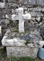
(12) At the fork in the road, take the left-hand branch. At this point, the IGN map is incorrect. Ford the stream three times over a distance of 300 metres. Halfway along, you’ll come across the ruins of the Madeleine sarcophagus. After thethird ford, follow the stream on your left until you reach a bridge.

Yellow markings – Bonnan Valley

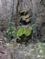
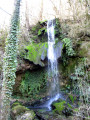
(13) Cross the bridge and continue to the right towards the petrified waterfall. In summer, the waterfall is dry, but in winter the spring flows abundantly. It is possible to walk right up to its source.

(14) Tuff waterfall. Continue along the stream until you reach the next bridge and cross it. Note, as you pass, just before the bend towards the bridge, a huge, centuries-old elm tree on the right.

(15) At the T-junction, turn left to rejoin the fork you took on the way out.

(1) Continue along the road leading uphill opposite and retrace the section you took at the start in the opposite direction to return to the car park (S/E).


Waypoints

  1. S/E : mi 0 - alt. 459 ft - Car park at the village hall
  2. 1 : mi 0.7 - alt. 499 ft - Junction of the circular loop and the Bonnan stream
  3. 2 : mi 1.14 - alt. 676 ft - Turn left towards the pylon
  4. 3 : mi 3.56 - alt. 1,204 ft - Left-right zigzag
  5. 4 : mi 3.74 - alt. 1,257 ft - Inter-municipal footpath
  6. 5 : mi 3.9 - alt. 1,152 ft - Turn left onto the GRP
  7. 6 : mi 4.39 - alt. 1,348 ft - Cairn
  8. 7 : mi 4.49 - alt. 1,368 ft - Dolmen at Orsayrolles (the former name of Roussayrolles)
  9. 8 : mi 5.38 - alt. 1,388 ft - Turn left at the crossroads
  10. 9 : mi 5.58 - alt. 1,352 ft - Roussayrolles Church
  11. 10 : mi 6.02 - alt. 1,234 ft - Road crossing
  12. 11 : mi 6.28 - alt. 1,207 ft - Dirt track
  13. 12 : mi 7.23 - alt. 843 ft - Turn left at the fork in the road
  14. 13 : mi 7.66 - alt. 659 ft - Crossing the Bonnan stream
  15. 14 : mi 7.72 - alt. 643 ft - Tuff waterfall
  16. 15 : mi 8.75 - alt. 512 ft - At the T-junction, turn left - Cascade de Bonnan
  17. S/E : mi 9.74 - alt. 449 ft - Car park at the village hall.

Notes

Water point and toilets in the car park of the Milhars village hall.
Picnic tables in Roussayrolles.
Water point and toilets next to Roussayrolles town hall.

Worth a visit

Dolmen at d’Orsayrolles (the former name of Roussayrolles).
Tuff waterfall.
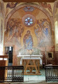
Roussayrolles Church, decorated by Nicolaï Greschny
Ask for the key and a guided tour (free of charge) at the town hall.
All the ceramic plaques in the village (street names, information boards, etc.) were created by Marie Costes

A little background on the two frescoes in this church, painted in 1950.
N. Greschny’s work had to be carried out on fresh concrete.
Each of the murals was completed, from the first pencil stroke to the final brushstroke, in the space of 15 days.

Reviews and comments

4 / 5
Based on 2 reviews

Reliability of the description
4 / 5
Ease of following the route
4.5 / 5
Route interest
3.5 / 5
surpilix
surpilix

Overall rating : 3.7 / 5

Date of your route : Jun 11, 2022
Reliability of the description : ★★★★★ Very good
Ease of following the route : ★★★★☆ Good
Route interest : ★★☆☆☆ Disappointing
Very busy route : No

A largely shaded route; the main challenge is the uphill stretch right from the start, covering several kilometres
Disappointing right up to point 7! Couldn’t find the dolmen; the path was impassable, with no clear route or signposting!
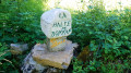
A bench for a lunch break before point 15, ‘Halte de Bonnan’
The ‘petrified waterfall’ was dry! The church was locked; we knocked on the neighbours’ doors to get the key, but got no reply at all!
A very disappointing route with little of interest

Machine-translated

madydou
madydou ★

Hello LaPierre,
Thank you for your feedback.
I’ll see how I can make the explanations clearer.

Machine-translated

LaPierre
LaPierre

Overall rating : 4.3 / 5

Date of your route : Jun 19, 2021
Reliability of the description : ★★★☆☆ Average
Ease of following the route : ★★★★★ Very good
Route interest : ★★★★★ Very good
Very busy route : No

A pleasant walk, often in the shade, which is a real bonus.
Several points of interest, such as the petrified (or petrifying…) waterfall, which was hopelessly dry (so early in the year – summer hasn’t even started yet – which is very worrying) and the dolmen.
The interior of Roussayroles church is definitely worth a look (once you’ve managed to track down the enormous key, somewhere in the village...).
After point 14, we crossed the stream again to head up the other bank to ‘l’étable du bonheur’ (a tiny place, apparently being prepared as an exhibition space for rural artefacts).
The village of Milhars itself, which is very authentic, is well worth a visit.
Note: a suggestion for improvement – we found the written description a bit confusing on several occasions. In fact, there may be too many explanations; the map is almost sufficient on its own.

Machine-translated

Other walks in the area

For more walks, use our search engine .

The GPS track and description are the property of this route's author. Please do not copy them without permission.