From La Chapelle Neuve towards the Floranges Forest

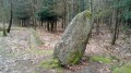
Starting from La Chapelle-Neuve, home to the oldest chapel in the department, we invite you to discover the springs of all the neighbouring streams, some of which feature fountains, such as the one at Saint-Mamert near Locmaria. You will then walk through the Floranges Forest where, with a few short detours (not described below), there are three megalithic monuments to see.

Details

67280108
Creation:
Last update:
Last review:
  • Walking
    Activity: Walking
  • ↔
    Distance: 7.44 mi
  • ◔
    Average duration: 3h 40 
  • ▲
    Difficulty: Moderate

  • ⚐
    Back to start: Yes
  • ↗
    Ascent: + 312 ft
  • ↘
    Descent: - 341 ft

  • ▲
    Highest point: 354 ft
  • ▼
    Lowest point: 118 ft

Description of the walk

Park in the car park behind La Chapelle Neuve Town Hall.

The entire route is signposted in yellow (PR®®).

(S/E) Head to the fountain and turn left to walk alongside the Lotissement de la Fontaine housing estate. At the end of the street, continue left onto Rue de Floranges. Follow it round the bend to the left until you reach the Kerjosse crossroads. Turn left, then, 200 metres further on, turn right towards the Kerjosse Mill. Cross the Tallené Stream and continue straight on to reach the hamlet of Kerbédic.

(1) Leave the road and carry on straight ahead, heading west-south-west. Cross the Tarun and you’ll come to a path on the edge of a copse near Kergaho. Turn left and follow the path to Kerbarh, where it joins the D189.

(2) Turn right onto it, then, after about 150 m, take the path on the right. Soon after, turn left to reach Locmaria. First turn left then right towards the Locmaria Chapel.

(3) In front of the chapel, turn left into Rue Kreiz Ker then right into Rue des Sources. Pass Guernic then, after the bend to the right, reach Petit Guernic. Immediately after the house, turn left. Further on, continue to the left then, after 200 m, take a hairpin bend to the right and come out onto a wider path.

(4) Turn left, then quickly take a path on the left, heading north-east.

(5) Turn right and, as you approach a forest track, turn left again, then cross the Route de Poulihuern. Continue straight ahead along the path leading to the Route de Kerblouz. Make two 20-metre right-left-right turns and continue along the edge of the woodland.

(6) At the fork in the road, turn right to follow the Goyedon stream (on the left, the descent is steeper and the path may be blocked by fallen trees). Before the stream, turn left and follow the watercourse. The path leaves the stream, veering first to the left and then to the right to reach Kervolanec.

(7) After Kervolanec, the route takes a short detour to the right towards the Moulin des Korrigans, making two left turns and then two right turns, before reaching a crossroads after crossing the Ruisseau le Goyedon once more.

(8) Turn left, heading due north, cross the Tarun again and continue to a four-way junction. Take the left-hand road. Pass the sewage treatment works on your left and turn right.

(9) Just before reaching the departmental road, turn left to walk alongside the tennis courts via Rue du Stade. Continue to the right towards the Résidence des Pins, then turn left to follow a footpath – which continues along the street – leading to the town hall car park (S/E).

Waypoints

  1. S/E : mi 0 - alt. 233 ft - La Chapelle Neuve Town Hall
  2. 1 : mi 0.77 - alt. 135 ft - The hamlet of Kerbédic
  3. 2 : mi 1.57 - alt. 171 ft - Kerbarh - Tarun (cours d'eau) - Affluent de l'Ével
  4. 3 : mi 2.15 - alt. 289 ft - Locmaria Chapel
  5. 4 : mi 3.11 - alt. 351 ft - Floranges State Forest
  6. 5 : mi 3.63 - alt. 328 ft - Path on the right
  7. 6 : mi 4.38 - alt. 295 ft - Stang Spring
  8. 7 : mi 5.39 - alt. 253 ft - The hamlet of Kervolanec
  9. 8 : mi 6.41 - alt. 148 ft - Crossroads, elevation 46
  10. 9 : mi 7.16 - alt. 220 ft - The New Chapel
  11. S/E : mi 7.44 - alt. 233 ft - La Chapelle Neuve Town Hall

Worth a visit

Always be cautious and plan ahead when you're outdoors. Visorando and the author of this route cannot be held responsible for any accidents occurring on this route.

The GR® and PR® markings are the intellectual property of the Fédération Française de Randonnée Pédestre.

Reviews and comments

4.5 / 5
Based on 2 reviews

Reliability of the description
4.5 / 5
Ease of following the route
4.5 / 5
Route interest
4.5 / 5
FarMeb
FarMeb
• Edited:

Overall rating : 5 / 5

Date of your route : Aug 27, 2026
Reliability of the description : ★★★★★ Very good
Ease of following the route : ★★★★★ Very good
Route interest : ★★★★★ Very good
Very busy route : No

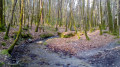
An exceptional walk, particularly from point 6 onwards; the start is a bit of a slog (the issues mentioned in the previous review have been rectified), although two does were kind enough to come to the edge of the forest to graze in the fields bordering the start of the route. The first four points offer the chance to see the sheep, goats and horses that inhabit the enclosures. Watch out for unmarked electric fences. From point 6 onwards, you walk alongside the Tarun, a forest stream. Deep-cut paths, birds coming to drink, wild boar tracks – a real treat in summer. In my opinion, in winter the mud and possibly the hunters can make the route more difficult.

The end of the walk is more conventional – and even a bit dreary – as it runs alongside the road. Best done in summer.

Machine-translated

Pascal C56
Pascal C56

Overall rating : 4 / 5

Date of your route : Apr 13, 2025
Reliability of the description : ★★★★☆ Good
Ease of following the route : ★★★★☆ Good
Route interest : ★★★★☆ Good
Very busy route : No

A pleasant route with nothing particularly remarkable about it, but enjoyable nonetheless.
Please note that at point 6, the route described is no longer passable – the aftermath of Storm Ciaran has blocked access, unless you’re prepared to wade through gorse and brambles in the undergrowth on a steep slope, and with the help of the app, which is essential to avoid getting lost! In that case, follow the alternative route suggested and stay on the footpath, which is clearly marked at regular intervals and therefore remains easy to follow.

Machine-translated

Other walks in the area

For more walks, use our search engine .

The GPS track and description are the property of this route's author. Please do not copy them without permission.