From Bains-les-Bains to Étang Lallemand

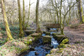
Along a narrow country lane, the rural landscape surrounding the resort of Bains-les-Bains soon unfolds before walkers: green hills, damp woodland and a wooden bridge spanning the Ru Migaille, near the ruins of the old Quénot Forge.

Details

35102280
Creation:
Last update:
Last review:
  • Walking
    Activity: Walking
  • ↔
    Distance: 5.89 mi
  • ◔
    Average duration: 3h 00 
  • ▲
    Difficulty: Moderate

  • ⚐
    Back to start: Yes
  • ↗
    Ascent: + 371 ft
  • ↘
    Descent: - 361 ft

  • ▲
    Highest point: 1,211 ft
  • ▼
    Lowest point: 978 ft

Description of the walk

From Saint-Loup-sur-Semouse, take the D64 towards Bain-les-Bains (in the commune of La Vôge-les-Bains). Park near the tourist information office.

Red Triangle signposting

(S/E) With your back to the tourist information office, turn right onto Avenue André Demazure, then immediately left, heading towards the town hall via the pedestrianised street.

Green Ring signposting

(1) After the pedestrian street, follow the Green Ring signposting. Walk past the town hall and continue straight on along Rue Général Leclerc. Ignore the first junction and you’ll come to a second one.

(2) Carry on straight ahead, then continue straight across onto Rue du Haut Champ for 150 m, until you reach the second Y-junction.

(3) Turn slightly right onto Rue Haute and gradually head into the countryside, through fields and woodland. Cross the D164 (a busy road).

(4) Carry on straight ahead and stay on Chemin de la Basse du Pommier until it ends. Continue along the dirt track that extends from it, until you reach the Ru Migaille, near the Forge Quenot.

(5) Cross the stream and pass the forge, then take two hairpin bends and emerge onto the Chemin du Ru de Migaille. Turn right to reach the protected site of Étang Lallemand, in the commune of Les Voivres, with its fish farm. It is an ideal spot for a picnic break, or for observing the flora and fauna of the wetlands. This site is also listed by the Lorraine Observatory for Sensitive Environments.

(6) Take the stony track on the right and continue across the meadows towards Blanche Borne, always following the Green Ring markings. Carry on straight ahead until you reach the Route des Trois Fontaines. Follow this road until you come to a four-way junction.

(7) Turn right and carry on straight ahead for 1 km until you reach the end of the road.

(8) Turn left and continue for 250 metres, then turn right and follow the road back towards Vôge-Les-Bains. Join the D164.

(9) Cross the D164 carefully and carry on straight ahead along Rue des Creuses until it ends, passing the Les Pins campsite.

(2) Turn left onto the Rue du Général Leclerc and return to the tourist office (S/E) by following the route in reverse.


Waypoints

  1. S/E : mi 0 - alt. 1,010 ft - Vôge-les-Bains Tourist Office
  2. 1 : mi 0.06 - alt. 1,020 ft - Vôge-les-Bains Town Hall. Near the - Bagnerot (cours d'eau)
  3. 2 : mi 0.25 - alt. 1,040 ft - Junction of the circular loop
  4. 3 : mi 0.36 - alt. 1,083 ft - Turn right towards Rue Haute
  5. 4 : mi 0.66 - alt. 1,096 ft - D 164. Passage near the - Côney (rivière)
  6. 5 : mi 2.09 - alt. 978 ft - Ru Migaille. Near the - Canal de l'Est
  7. 6 : mi 2.65 - alt. 1,102 ft - Lallemand Pond
  8. 7 : mi 3.83 - alt. 1,201 ft - Crossroads
  9. 8 : mi 4.44 - alt. 1,188 ft - Junction
  10. 9 : mi 5.11 - alt. 1,132 ft - D 164
  11. S/E : mi 5.89 - alt. 1,010 ft - Vôge-les-Bains Tourist Office

Notes

Thank you to the Club Vosgien and the walking section of the MJC in Bains-les-Bains for organising this walk and for the work carried out by their teams throughout the year to signpost and maintain these paths.

Worth a visit

Forge Quénot: a former ironworks, of which only the ruins remain.

(6) Lallemand Pond: created in 1572 to serve as a reservoir for the canton’s first ironworks.

Reviews and comments

4 / 5
Based on 4 reviews

Reliability of the description
4 / 5
Ease of following the route
4.5 / 5
Route interest
3.5 / 5
randonanard
randonanard

Overall rating : 4 / 5

Date of your route : Jul 13, 2026
Reliability of the description : ★★★★☆ Good
Ease of following the route : ★★★★★ Very good
Route interest : ★★★☆☆ Average
Very busy route : Yes

Apart from Lallemand Pond, there’s nothing particularly interesting – just a lot of driving.

Machine-translated

HOUTMANN Luc
HOUTMANN Luc

Overall rating : 3.3 / 5

Date of your route : Apr 21, 2025
Reliability of the description : ★★★★☆ Good
Ease of following the route : ★★★☆☆ Average
Route interest : ★★★☆☆ Average
Very busy route : Yes

I set off on the walk from the Place de la Fête, following the signposted trail: Blue Disc, passing through Basse du Pommier, Pré Bobant, Forge QUENOT, Étang Lallemand, Blanche Borne, Trois Fontaines, Petite Rappe, Grande Rappe, the recycling centre, Camping des Pins, Rue des Creuses and Rue du Général Leclerc, before returning to the starting point.
There is certainly too much tarmac and forest track on this route, and generally speaking on all the routes in this area.

Machine-translated

fanfan
fanfan

Overall rating : 4.3 / 5

Date of your route : Mar 27, 2025
Reliability of the description : ★★★★☆ Good
Ease of following the route : ★★★★★ Very good
Route interest : ★★★★☆ Good
Very busy route : No

Hello,
Thank you for this lovely route, which leads to the stunning setting of the Lallemand ponds, where we spent a little time strolling along the banks.
Our only regret is that there’s too much tarmac: 6.9km out of a total walk of 9.9km.
In hot weather, it would be very tiring to walk along all those tarmac roads.

Bains-les-Bains is a lovely place to visit.

Thank you again, and see you soon on other walks.

Fanfan

Machine-translated

Yvan Clair
Yvan Clair

Overall rating : 4.3 / 5

Date of your route : Jul 24, 2023
Reliability of the description : ★★★★☆ Good
Ease of following the route : ★★★★★ Very good
Route interest : ★★★★☆ Good
Very busy route : No

a route that lives up to its description

Machine-translated

Other walks in the area

For more walks, use our search engine .

The GPS track and description are the property of this route's author. Please do not copy them without permission.