Route of the Village of the Year 1000

Immerse yourself in history through Melrand’s heritage. This route will take you past manor houses, mills, wells and characterful houses. You’ll also pass by the Oratoire Saint-Laurent, the Chapelle de la Madeleine, the Kerstraquel lake and, of course, the Village de l’An Mil.

Details

105940877
Creation:
Last update:
Last review:
  • Walking
    Activity: Walking
  • ↔
    Distance: 2.68 mi
  • ◔
    Average duration: 1h 25 
  • ▲
    Difficulty: Easy

  • ⚐
    Back to start: Yes
  • ↗
    Ascent: + 174 ft
  • ↘
    Descent: - 177 ft

  • ▲
    Highest point: 328 ft
  • ▼
    Lowest point: 154 ft

Description of the walk

(S/E) From the village centre, take the street on the right, then Rue Saint-Laurent on the left to reach the oratory, the chancel of the former Saint-Laurent Chapel.

(1) You can also see its fountain on your right, 25 metres further down the slope. Head back towards the village along the edge of the lake. Walk past the children’s playground and head towards the covered wash house. Go down the road to the right, then turn left into Rue d’Angleterre. On your right, you’ll see the Manoir du Bot, dating from themid-15th century.

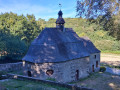
(2) At the end of the street, turn right, then make sure you don’t miss the Chemin du Meunier on the left. Continue along this idyllic path, which crosses the River Sarre , whose power once drove the surrounding mills. Walk past the weir and you’ll reach the Chapelle de la Madeleine, built at the end of the16th century. In the past, La Madeleine was home to lepers who were banished from the village. They were assigned the task of plaiting ropes from hemp and flax. After the chapel, turn right twice; take care when crossing the county road.

(4) Then turn right, then left, and head up to the right towards the Village de l’An Mil, crossing the small wood. The archaeological site of the Village de l’An Mil was discovered in 1902 by an archaeologist. The remains of an ancient village are still clearly visible. Reconstructions of buildings such as the granary on stilts, the thatched cottage and the oven allow you to immerse yourself in the daily life of medieval peasants.

(5) Turn back and, at the bend, continue downhill opposite through the woodland. When you reach the road, turn right. Take a quick left-right turn, then keep left onto a path leading to the picnic area and on to the banks of the lake.

(6) After walking round the lake on the left-hand side, cross the river via a small wooden bridge, turn right and rejoin the road.

(7) Turn left, then right at the crossroads to pass in front of the ‘Cosprado’ wash house (meaning ‘old meadows’ in Breton) and follow the bell tower to reach the church (S/E).

Waypoints

  1. S/E : mi 0 - alt. 203 ft - église Saint-Pierre de Melrand
  2. 1 : mi 0.18 - alt. 207 ft - St Laurent Chapel
  3. 2 : mi 0.57 - alt. 177 ft - End of the street
  4. 3 : mi 0.8 - alt. 157 ft - Chapel of La Madeleine
  5. 4 : mi 0.98 - alt. 171 ft - Departmental road
  6. 5 : mi 1.38 - alt. 328 ft - Village of l’An Mil
  7. 6 : mi 1.97 - alt. 167 ft - Kerstraquel Pond
  8. 7 : mi 2.29 - alt. 167 ft - Route
  9. S/E : mi 2.69 - alt. 203 ft - église Saint-Pierre de Melrand

Notes

Car park, shops and restaurants at the start of the walk.

Worth a visit

- Saint-Laurent Oratory and its fountain

The sanctuary was built at the same time as the present church, in the first half of the15th century. The lords of Kerveno may well have been behind its construction, as suggested by the coat of arms featuring ten stars carved on the fountain. Due to a lack of maintenance, the chapel was demolished in 1962; only part of the chancel was preserved to create an oratory, open to the west through a large archway.

- Chapel of Our Lady of Magdala

The Chapel of La Madeleine was built in the late16th or early17th century, right next to the River Saar. Its bell tower was probably rebuilt in the first quarter ofthe 18th century, along with the bell, which was consecrated in 1711. A window was added to the south wall inthe mid-19th century. Restoration work was carried out between 1978 and 1990.

- Village of the Year 1000

This unique archaeological site offers an insight into everyday life in the countryside during the Middle Ages. Discovered in 1902 by an archaeologist, the remains of houses, streets and courtyards are still clearly visible today. The garden, the animals and the reconstructions of dwellings will allow you to immerse yourself in the lives of the inhabitants throughout the seasons.
You can visit the site all year round (admission fee applies)

Other walks in the area

For more walks, use our search engine .

The GPS track and description are the property of this route's author. Please do not copy them without permission.