The Bois du Puy route in Grez-en-Bouère and Saint-Charles-la-Forêt

This long route will take you through the countryside of southern Mayenne, as well as the lovely woodland near the village of
Saint-Charles-la-Forêt. Do make a detour to see the watermill in Grez-en-Bouère,
an iconic landmark of the region.

Details

n°413487
Creation:
Last update:
Last review:
  • Walking
    Activity: Walking
  • ↔
    Distance: 9.99 mi
  • ◔
    Average duration: 4h 40 
  • ▲
    Difficulty: Difficult

  • ⚐
    Back to start: Yes
  • ↗
    Ascent: + 125 ft
  • ↘
    Descent: - 108 ft

  • ▲
    Highest point: 390 ft
  • ▼
    Lowest point: 262 ft

Photos

Description of the walk

Start from the church in Grez-en-Bouère.

(S/E) Start from the swimming pool car park in St Charles la Forêt. Leave the car park on the right and take the
D285 towards Le Buret. After 300 m, turn right onto the Chemin des Caves, then after 100 m,
turn left. Continue straight on along this greenway. At the end, turn left and
follow the tarmac road for 600 m, then turn left to reach the D14.

(1) Cross it (a minor road) and go straight on for about 700 m. Then
take a track on the right and follow it up to the village of Les Bouhourdières. In the village, carry on
straight on along a grassy track. Continue for 500 m, then turn right. Carry on along this track for 1.5 km until you reach the D14 again.

(2) Please note: temporary road. Turn right for 100 m, then left onto the Circuit de Gérigné. On your
left, you’ll see the Guénaudière watermill. After 1.6 km, turn left onto the
Chemin de La Cherrière. Follow this track for about 800 m. Cross the D109 and take the
du Moorëa for 650 m. Take a green path on the right and continue for 1.5 km. Then turn
right onto the D610 for 300 m.

(3) At a place called L’Espérance (junction of the D610 and the D109), turn left onto the D109 for
800 m. Then turn right onto a forest track that crosses the Bois du Puy. After Haut Meré, you’ll
will see the Grand Buisson stud farm on your right. At the small tarmac road, turn right and
follow it for about 1.3 km. At the junction with the D285, turn left onto the road which will
back to the village and your starting point (S/E)


Waypoints

  1. S/E : mi 0 - alt. 371 ft - Saint-Charles-la-Forêt swimming pool car park
  2. 1 : mi 1.42 - alt. 367 ft - D14, turn right
  3. 2 : mi 4.14 - alt. 272 ft - Turn right and walk 100 m
  4. 3 : mi 7.24 - alt. 341 ft - Turn left onto the D109
  5. S/E : mi 9.99 - alt. 371 ft - Saint-Charles-la-Forêt swimming pool car park

Notes

Saint-Charles-la-Forêt Town Hall – 1 route de Longuefuye, 53170 Saint-Charles-la-Forêt // 02 43 98 44 17

Nearby restaurants and bars: Au p’tit grez in Grez-en-Bouère, Le Camélia in Ruillé-Froid-Fonds, Le Bon accueil in Ruillé-Froid-Fonds

Toilets: near the church, near the lake

Worth a visit

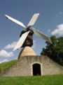
La Guénaudière windmill, Grez-en-Bouère: this windmill, originally from the south of the Loire, is
composed of three parts: the hucherolle (wooden cage), the massereau (masonry cone) and the cellar covered
with an earthen embankment. The latter housed the millstones and gives the building its name. Dating from 1829, it
has been listed as a historic monument since 1984 and is the only one of its kind in Mayenne.

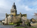
Church, Saint-Charles-la-Forêt: it was built between 1842 and 1856 on the initiative of Monsignor Bouvier, Bishop of Le Mans, on the ruins of the old church founded in 1684. It is dedicated to Saint Charles Borromeo, Bishop of Milan, who is invoked for protection against the plague.

Trivia: in the 1950s, a ‘17’ competition – a card game similar to ‘manille’ – was established in the commune of Saint-Charles-la-Forêt. It quickly gained widespread popularity, growing from 184 players in 1956 to over 20,000 participants in 1976. The profits were used, in particular, to fund several facilities: a swimming pool, a holiday village, two ponds, a leisure centre, and so on.

Reviews and comments

3.8 / 5
Based on 2 reviews

Reliability of the description
4 / 5
Ease of following the route
4 / 5
Route interest
3.5 / 5
sabrina houdou
sabrina houdou

Overall rating : 4 / 5

Date of your route : Aug 27, 2023
Reliability of the description : ★★★★☆ Good
Ease of following the route : ★★★★☆ Good
Route interest : ★★★★☆ Good
Very busy route : No

I’d chosen this route because it’s described as difficult, but it’s actually very easy. No hills at all, just flat ground. At point 3, the path was overgrown with brambles.
I took a detour to see the mill. You can stop for a break on the little bench there. And it’s practically on the route. I couldn’t find anywhere to have a picnic, though.
The last part is almost entirely on the road, but it’s very easy to manage. In short, a really easy and well-signposted walk.

Machine-translated

Sud Mayenne tourisme

Hello,

thank you for your comment. We are passing on the information regarding the maintenance of the path mentioned in your message to those responsible for this area.

Kind regards.

Machine-translated

elisapasvtt
elisapasvtt

Overall rating : 3.7 / 5

Date of your route : Oct 19, 2018
Reliability of the description : ★★★★☆ Good
Ease of following the route : ★★★★☆ Good
Route interest : ★★★☆☆ Average

Hello
This is a mountain bike route; the very start of the route between Grez-en-Bouère and Le Cotillon Rouge is well signposted, either with yellow and black signs or yellow walking markers on trees or telephone poles – it’s easy to find your way!
The second part is mostly tarmac; the only snag is point 7 on the path after La Turmerie – a real bramble thicket that’s impassable even on foot for part of its length. The only solution is to follow the path running parallel through the cultivated field next to it
All in all, a lovely walk in the fresh air, provided the sun’s out and the paths aren’t too muddy; the St Charles pond and the Cavier mill in Grez-en-Bouere are well worth a detour.
Best regards

Machine-translated

Other walks in the area

For more walks, use our search engine .

The GPS track and description are the property of this route's author. Please do not copy them without permission.