Chemin de Cordailleux

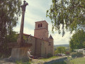
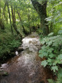
On leaving the village, as you head down towards the wash house along the sunny side of the hillside, you can admire the Charavan ravine and the Bouchat woods. The footbridge over this stream leads to a disused leat, a reminder of rural life in days gone by. The return route via the Charavan footbridges passes close to a ‘devil’s game’ hidden beneath the moss. On the flat stretch, the Montel picnic area and book box provide a pleasant end to this walk.

Details

4320984
Creation:
Last update:
Last review:
  • Walking
    Activity: Walking
  • ↔
    Distance: 3.45 mi
  • ◔
    Average duration: 2h 05 
  • ▲
    Difficulty: Easy

  • ⚐
    Back to start: Yes
  • ↗
    Ascent: + 541 ft
  • ↘
    Descent: - 538 ft

  • ▲
    Highest point: 2,723 ft
  • ▼
    Lowest point: 2,277 ft

Description of the walk

Park at Place de l’Église in the village of Bard.

(S/E) From the church car park, head down towards the war memorial, walk past it and take the path on the right. Admire the ‘Grand Font’ on your right. Continue to the river, cross it and head back up towards Le Plenet.

(1) As you emerge from the woods, take the first path on the right, lined with a stone wall. Follow it for 200 m.

(2) Turn left onto a small, well-maintained path before the track descends into the valley. Follow the path until you reach the edge of a field. Take the path on your right and stay on it until you reach the next hamlet, Condamines.

(3) Turn right after the two porticoes, cross the hamlet, then turn right. The path offers a magnificent view of the village of Bard and the plain. If you turn right here, it joins the PR®8. Then continue to the left, descending towards the River Charavan. Cross it twice before climbing a steep path through a wood of wild garlic. This brings you onto the PR®5 by turning right. Follow it to the picnic tables.

(4) Take the D113 on the right for about a hundred metres and turn left onto the small tarmac road signposted ‘Le Montel’. At the cross, turn right and follow the path which joins a small road. Follow this to the left towards Les Grangères.

(5) Turn left onto the dirt track. At the end of this track, the PR®5 turns left. Keep the PR®7 on your right.

(6) At the stone cross, take the tarmac road on the left, which takes you back to the village of Bard (S/E).


Waypoints

  1. S/E : mi 0 - alt. 2,500 ft - Car park - Église Saint-Jean (Bard)
  2. 1 : mi 0.8 - alt. 2,497 ft - Bois du Bouchat
  3. 2 : mi 0.98 - alt. 2,526 ft - Junction
  4. 3 : mi 1.21 - alt. 2,684 ft - Condamine
  5. 4 : mi 2.31 - alt. 2,677 ft - Junction with the D113
  6. 5 : mi 2.9 - alt. 2,641 ft - Les Grangères
  7. 6 : mi 3.2 - alt. 2,612 ft - Cross
  8. S/E : mi 3.45 - alt. 2,500 ft - Car park - Église Saint-Jean (Bard)

Notes

Worth a visit

Access to the Pic de Bard (round trip) at (6).
In the village, you can eat at the Auberge de Bard.

Always be cautious and plan ahead when you're outdoors. Visorando and the author of this route cannot be held responsible for any accidents occurring on this route.

The GR® and PR® markings are the intellectual property of the Fédération Française de Randonnée Pédestre.

Reviews and comments

4.5 / 5
Based on 2 reviews

Reliability of the description
5 / 5
Ease of following the route
3.5 / 5
Route interest
5 / 5
Commune de BARD
Commune de BARD

Hello,
Thank you for your feedback; we will get in touch with the foresters
Kind regards

Machine-translated

tofebrige
tofebrige

Overall rating : 4 / 5

Date of your route : Apr 22, 2024
Reliability of the description : ★★★★★ Very good
Ease of following the route : ★★☆☆☆ Disappointing
Route interest : ★★★★★ Very good
Very busy route : No

We rated the ease of following the route as ‘disappointing’, as forestry work has made the path very muddy and impassable at this time of year. We struggled to cut across the woods to rejoin the rest of the route and thus avoid the impassable section. However, it is a very pleasant route during very dry periods and when there is no work taking place. It’s a shame that the work isn’t signposted. Regards

Machine-translated

Loz42100
Loz42100

Overall rating : 5 / 5

Date of your route : Sep 18, 2023
Reliability of the description : ★★★★★ Very good
Ease of following the route : ★★★★★ Very good
Route interest : ★★★★★ Very good
Very busy route : No

A lovely family walk; the paths are in good condition. Definitely worth a go.

Machine-translated

Other walks in the area

For more walks, use our search engine .

The GPS track and description are the property of this route's author. Please do not copy them without permission.