Country:
 City:
City:


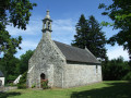
At the three-way junction at the hamlet of Le Drennec on the D34 (Bénodet–Quimper or vice versa), turn right or left depending on the direction from which you’re coming, towards Clohars-Fouesnant (D134). Pass the chapel (on the left) and Rue Saint-Alar (on the right) and head for the car park, which is on the left a few dozen metres further on.
(S/E) On leaving the car park, carefully head up Route de la Chapelle on the right. When you reach the chapel, turn left onto Rue Saint-Alar at the corner by a restaurant, and continue until you reach the ‘No Entry’ sign.
(1) Carefully follow the D34 to the left for about a hundred metres, then cross it with extreme caution (there is no pedestrian crossing) and take the old route of the departmental road known as Hent Pradérez. At the end of this disused stretch of road, return to the RD34 and walk alongside it, still taking care, for about a hundred metres.
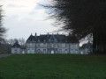
(2) Turn right onto the Route de Squividan. This road passes through a wooded area and a marshy area on the right-hand side, then curves to the right before Squividan, leading to the Manoir de Squividan in Squividan Vras.
(3) Continue along the road until you reach the ‘Give Way’ sign on the D34.
(4) At the sign, turn right and, a few metres further on, cross with extreme caution (as there is no protected crossing) to join Route de Kerangouic. Follow this road, ignoring the path on the left, passing by the Manoir du Drennec (a former 16th-century vicarage) and continuing to the hamlet of Kerangouic, ignoring the road on the right leading to Keranrouz and the Kerangouic farm. You will reach a crossroads at the end of the tarmac road.
(5) Turn right onto a tree-lined path, go through a gate and reach a crossroad at a place called Keralis (Allée Vibert).
(6) Turn left onto this road, then turn left again at the first dead end (Parc Kroaz). At No. 3, turn right onto the small path that goes round the houses and reach the D45 (Ty Kervarec).
(7) Turn right, pass Allée Vibert, then take the bridle path on the right. After about 150 m, turn left onto a short slip road to join the Route de Pont Coulouffant. Turn left and rejoin the D45.
(8) Turn right onto this road. After the first few houses, head for the path on the right-hand side which leads to the school roundabout. Cross at one of the pedestrian crossings, take Rue de l’École opposite and walk alongside the sports ground car park. Take the path at the far end on the right, pass the René Tressard school and, after the building, turn right to reach a street. Turn left and take the path leading to a small road.
(9) Turn left onto this road, then turn left again onto a street and follow it to the end to reach the junction with Rue de Bellevue, near the Post Office sorting centre. Walk down this street to the left until you reach the junction with the D45, which you passed on the way there.
(7) Cross with care, then turn right and walk along the fairly wide, grassy verge (in single file if you’re in a group) until you reach the path starting on the left after the decorated water tower, opposite the restaurant entrance.
(10) Take this path and walk to the Kerangouic junction, which you’ve already passed on the way there.
(5) Turn left to follow the tree-lined path back in the opposite direction to the outward journey, and reach Allée Viber in Keraris at the junction you passed on the outward journey.
(6) Turn right, passing two dead-end streets on the left.
(11) Turn right onto the grassy track leading to Chemin de Kervas, then follow it as it veers left. You’ll come out onto Route de la Chapelle (D134).
(12) Make one final change of direction by turning right and walk carefully to return to the car park where you started (S/E).
 Visorando Member

 Moderate