Country:
 City:
City:


Starting point: Bourgueil Stadium
(S/E) With your back to the main stadium stands, take the path directly in front of you after the metal barrier. This path runs alongside the stadium on your right and follows the Allée de la Mailletterie, continuing straight ahead.
(1) Turn left, round the bend and you’ll reach a Fork in the road at La Villatte.
(2) Take the small footpath which leads you to the main road, Route de Tours. Take care when crossing the road and, directly opposite this path, take Rue de la Martellerie. You’ll pass a residential area on your right at a place called Les Noues.
(3) Turn right onto the small path as you leave this residential area and continue straight on until you reach the third junction.
(4) Turn right just before the Route du Carroi Taveau and, at the end, turn left towards the Route du Carroi Taveau.
(5) Turn right, then take the first road on the left, Chemin de Beau Puy, and carry on straight ahead until you reach the junction.
(6) Keep to the right and carry on until you reach the hamlet of Beau Puy. When you arrive near the houses in the hamlet, do not head towards them but take the path that is still straight ahead of you. Carry on straight ahead until you reach the small lake.
(7) Turn right to go round the pond. 100 metres further on, you’ll have the option to turn off to your right. Do not take this path but continue along the edge of the pond until you reach a fork in the path. Do not continue along the edge of the pond but carry on straight ahead. You will arrive at the Lande des Feuillarderie crossroads, marked at elevation 109 on the map.
(8) Take the path on the right all the way to the end, then turn right onto the Route de Courléon, then take the first path on the left until you rejoin theGR® and the first path coming from the right.
(9) Take the path on the right and continue until you reach a junction.
(10) Take the path on the left until you reach the end, then turn right until you come to a junction of two paths in Les Landes.
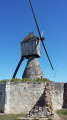
(11) Take the path on the left until you reach the iconic Moulin Bleu.
(12) Continue along the path towards the woods. This path is only accessible on foot. Further on, cross the Route de Courléon and take the path opposite until you reach the Route du Moulin Bleu, where you turn right. Keep following the road as it winds down the hillside. You’ll arrive in a residential area, at a place called Chevrette; carry on until you reach the junction.
(13) Turn right, then take thefirst left and follow the road to the end. There you’ll find a path on the right and another on the left. Take the one on the right and follow it to the end.
(14) Turn left and continue to the junction with Rue de Chevrette.
(15) Turn right. A little further on, you’ll reach the departmental road, the Route de Tours. Take care, as the road is very busy. Cross it and take the path directly opposite you. Carry on until you reach the roundabout.
(16) Take the first exit off the roundabout to reach the junction with the D63.
(17) Cross the road and carry on straight ahead, running alongside the cemetery on your right.
(18) Turn right just after the cemetery. The stadium (S/E) is at the end of this road.

 Visorando Member
 Easy
Easy 

 Tourist office