Saint-Lys Maquis Circular Loop

The route is almost entirely on tarmac, for days when the paths are impassable
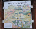
During the route, there’s a special focus on the Maquis de Saint-Lys and the battles of 12 June 1940.

Details

4430606
Creation:
Last update:
Last review:
  • Walking
    Activity: Walking
  • ↔
    Distance: 8.48 mi
  • ◔
    Average duration: 4h 10 
  • ▲
    Difficulty: Moderate

  • ⚐
    Back to start: Yes
  • ↗
    Ascent: + 276 ft
  • ↘
    Descent: - 305 ft

  • ▲
    Highest point: 932 ft
  • ▼
    Lowest point: 643 ft
  • ⚐ Country: France
  • ⚐ City: Fontenilles (31470)
  • ⚑
    Start/End: N 43.556978° / E 1.177921°
  • ❏
    IGN map(s): Ref. 2043ET
  • Hour-by-hour weather

Photos

Description of the walk

Park in the car park at the Fontenilles sports ground next to the sports centre

(S/E) With your back to the sports centre, take the old Lias road which goes round the rugby pitch; at the end of the road, take the path that runs behind the indoor tennis courts to reach the roundabout at the entrance to the Résidence des Magnolias

(1) Before reaching the roundabout, continue to the right along the footpath, then cross Avenue des Magnolias with care and, after the wooden gate, join the path that goes round the housing estate until you see Lac de L’Espêche.

(2) When you reach the lake, turn left onto the path leading to the hamlet of La Taillade. The path joins Chemin Garrousset, where you should turn right towards Bontepos-sur-Aussonnelle; this is theGR®86, marked in red and white. As you cross the municipal boundary, the path changes its name to Chemin de Mondou. Continue to a T-junction in the Mondou neighbourhood.

(3) Continue left along Chemin de Mondou, taking the footpath on the right and then on the left of the road. Carry on straight ahead, then cross the D12 Route de l’Isle Jourdain at the pedestrian crossing and continue straight on into Rue du Guigneriou until you reach the bridge over the Ruisseau du Bosc.

(4) Before the bridge, turn left onto the path that follows the stream to the wooden footbridge. Cross the stream via the footbridge and enter the local park. Walk round the park on the left-hand side and, at the exit, head straight on to rejoin the Allée du Pigeonnier. Pass under the dovecote and continue until you reach the D58G Route d’Empeaux, opposite the Town Hall.

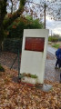
(5) Turn left onto the departmental road, which becomes Rue de l’Aussonnelle, and walk past a small pond on your left. For now, ignore the Chemin du Moulin on your right – you’ll take that later – and carry on to the Chemin du Peyra to see the monument dedicated to the Saint-Lys Maquis, then retrace your steps.

(6) Turn left onto the Chemin du Moulin and head up towards the Château du Candelé. After passing the Moulin housing estate, the road bends to the right and becomes the Voie Romaine in the commune of Saiguède. After passing the château, you’ll reach a T-junction.

(7) Leave the Voie Romaine, which continues straight on along a dirt track, and turn left onto Rue du 11 Novembre 1918, which leads down towards the village centre.

(8) At the bottom of the descent, before reaching the bridge over the Mescurt stream, turn left onto Chemin du Mescurt and follow it to the end.

(9) Turn left onto the D53B, Rue de Fontenilles, and start climbing. Halfway up the slope, take thefirst right onto Chemin Georges et Georgette Marty and head down towards Saint Lys until you reach thefirst T-junction at Les Maisons de la Pujade.

(10) Turn left onto Chemin Marcel Della Nora and continue across the Saiguède plain until you rejoin the D53B, Rue de Fontenilles. Turn right and rejoin the start of the Roman Road. Reach the junction with the D12 at Les Maisons des Cantous.

(11) Cross with care and continue straight ahead onto Route de Fontenilles, which becomes Route de Saiguède as you enter a different municipality. Cross the D68 (Route de Bonrepos) via the raised pedestrian crossing and continue straight ahead onto Impasse du Moulin. Pass under the ring road, then, behind the Saves housing estate, you’ll arrive opposite the children’s playground

(12) Before reaching Route de Saint-Lys, take the path on the left which runs behind the children’s playground and cross the Aussonnelle via the wooden footbridge. At the end of the footbridge, turn left onto the path which leads up to the Clos de Larcan housing estate. Continue along the footpath towards the cemetery and turn right into the passage between the houses overlooking the community gardens, continuing past the PAJ. Cross the covered hall and the boules courts to reach Avenue du 19 Mars 1962.

(13) Turn left onto the avenue, between the schools and the outdoor tennis courts, pass the cemetery and turn right onto the old Lias road, which is now cut off by the bypass that takes traffic round the centre of Fontenilles. Cross the bypass with care and rejoin the road you took in the opposite direction at the start of the exit, arriving at the sports centre car park (S/E).

Waypoints

  1. S/E : mi 0 - alt. 673 ft - Car park at the Fontenilles sports ground
  2. 1 : mi 0.32 - alt. 673 ft - Les Magnolias roundabout
  3. 2 : mi 0.71 - alt. 682 ft - Lac de L’Espêche
  4. 3 : mi 1.83 - alt. 722 ft - Mondou
  5. 4 : mi 2.15 - alt. 712 ft - Ruisseau du Bosc
  6. 5 : mi 2.5 - alt. 715 ft - Bonrepos Town Hall. On the left, Rue de l’ - Aussonnelle (rivière)
  7. 6 : mi 2.88 - alt. 732 ft - Chemin du Moulin
  8. 7 : mi 3.84 - alt. 932 ft - Roman Road
  9. 8 : mi 4.21 - alt. 745 ft - Mescurt Stream
  10. 9 : mi 4.52 - alt. 738 ft - Route de Fontenilles
  11. 10 : mi 5.12 - alt. 712 ft - Chemin Della Nora
  12. 11 : mi 5.84 - alt. 705 ft - D12 road
  13. 12 : mi 7.59 - alt. 650 ft - Children’s playground
  14. 13 : mi 7.85 - alt. 669 ft - Outdoor tennis courts
  15. S/E : mi 8.48 - alt. 673 ft - Car park at the Fontenilles sports ground

Notes

Next to Bonrepos Town Hall, there is a fountain with a tap providing drinking water.
There’s just one minor challenge: the climb up Chemin du Moulin in Bonrepos; the rest is flat.

Worth a visit

The villages of Bonrepos and Saiguède were the scene of fighting by the Maquis during the Second World War. There is a memorial at the entrance to the village of Bonrepos on the Saint-Lys side, and several commemorative plaques marking the sites of the fighting on 12 June 1940.
In Bonrepos’s village park, you can have a picnic, play table tennis and relax.
The dovecote along the route has been reconstructed; whilst not the original, it is modelled on those found in the region.
In front of Bonrepos Town Hall, there is a former weighbridge, and you can admire some trompe l’oeil paintings in the surrounding area.
There are some lovely views when you’re in the Moulin neighbourhood of Bonrepos.
Don’t miss the agroforestry site next to the sheep farm in Fontenilles on Chemin Garrousset.
At the entrance to Les Magnolias, you can admire the small fishing pond, which serves as a water reservoir; it’s a very pleasant walk around it.

Always be cautious and plan ahead when you're outdoors. Visorando and the author of this route cannot be held responsible for any accidents occurring on this route.

The GR® and PR® markings are the intellectual property of the Fédération Française de Randonnée Pédestre.

Reviews and comments

4.7 / 5
Based on 2 reviews

Reliability of the description
5 / 5
Ease of following the route
5 / 5
Route interest
4 / 5
sequoia1
sequoia1

Overall rating : 4.5 / 5

Date of your route : May 02, 2021
Reliability of the description : ★★★★★ Very good
Ease of following the route : Not used / Not applicable
Route interest : ★★★★☆ Good
Very busy route : Yes

Well worth a visit the day after heavy rainfall in the Saint-Lys–Fonsorbes–Fontenilles area.
Another point of interest is the information board about the Battle of the Saint-Lys Maquis at (5).
On Chemin Garousset (2), a ‘Partageons la Montagne’ sign warns of sheep guarded by Patou dogs and advises avoiding them . We saw the sheep but not the dogs: I’d rather come across a bear than those dogs.
At point 12, we didn’t spot the path to the right between the houses: we carried on straight ahead through the car park to the cemetery, then turned right, which took us back to Avenue du 19 Mars. But that’s a minor detail; otherwise, the route description is adequate.

Machine-translated

FGobin
FGobin

Overall rating : 4.7 / 5

Date of your route : Dec 28, 2020
Reliability of the description : ★★★★★ Very good
Ease of following the route : ★★★★★ Very good
Route interest : ★★★★☆ Good
Very busy route : No

Please note that there is an error with the GPS, so it cannot be imported.
Line 62 G&G Marty Trail
You need to remove the "&" to be able to import the GPX file into another app.

Machine-translated

Other walks in the area

For more walks, use our search engine .

The GPS track and description are the property of this route's author. Please do not copy them without permission.