Country:

 City:
City:


At Réotier, follow signs for Pinfol and, when you reach the climbing site, look out for the inconspicuous start of the path marked ‘Rabastelle Bas’ on the right. Park as close as possible to the start of the path.
(S/E) Climb the path, taking care to follow the cairns closely. You’ll reach a flat area where you can see numerous low walls; this is Rabastelle Bas. This site was inhabited in the Middle Ages.
(1) Cross the meadow and, at the far end, head down to the left into the woods, join the tarmac road and follow it to Pinfol.
(2) Pass the lodge on your left and, after the bend, look out for the start ofthe GR®®50. Follow it to the left, first up a steep climb, then onto a plateau. Note the numerous low walls to the left of the path, evidence of a former human settlement. Continue on level ground until you reach some ruins; this is Rabastelle Haut. This site was a hamlet that was also inhabited in medieval times.
(3) Continue along the path until it joins a wide forest track; keep going straight on. You’ll reach a clearing where you’ll see two large DFCI water tanks. Immediately afterwards, look out for the start of the path on the right.
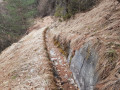
(4) Leave the track and head down to the right along this path (don’t worry if you lose the mark-outs as it is currently under construction). Head straight down, keeping to the left of a shallow ditch with a large black pipe running through it. At the bottom, where you can make out some meadows, head slightly to the right and look for the start of the Canal en Lauzes de Manouel. This canal dates from the 1930s and is built from flat stones known as ‘lauzes’. It is the longest lauze canal still in use in the Briançon region.
(5) Follow this canal to the right until you reach the tarmac road to Pinfol and return to the car park (S/E).


 Visorando Member
 Easy
Easy 
 Difficult