Circular Croisilles route towards the Eure valley

Our little village, Croisilles, is situated in the department of Eure-et-Loir and the Centre-Val de Loire region. It is close to Dreux, Chartres and Rambouillet. Around Croisilles, we are fortunate to have plains and woodland. This discovery walk allows you to explore the local flora and fauna as well as the village’s heritage. The route connects to theGR® de Pays Vallée de l’Eure in the Bois de Ruffin.

Details

45428965
Creation:
Last update:
Last review:
  • Walking
    Activity: Walking
  • ↔
    Distance: 6.91 mi
  • ◔
    Average duration: 3h 20 
  • ▲
    Difficulty: Moderate

  • ⚐
    Back to start: Yes
  • ↗
    Ascent: + 197 ft
  • ↘
    Descent: - 217 ft

  • ▲
    Highest point: 440 ft
  • ▼
    Lowest point: 292 ft

Description of the walk

(S/E) From the town hall car park, with your back to the town hall, turn right and head south-east along the Grande Rue until you reach the Croix de Saint-Servais.

(1) Take the path on the left and continue until you reach the junction with Rue d’Amfreville.

(2) Cross the road, then take the path opposite and continue along the path on the right (ignoring the paths on the left) until you reach the Chemin du Gland.

(3) Take the path on the right at a right angle and head towards the entrance to Bréchamps.

(4) Continue straight ahead and follow Rue du Bois aux Moines. At the end of the street, turn left, then take the first right. Pass Chemin des Haies on your right and continue to Rue de la Mare Rouge. Turn right onto this street, then head down Chemin du Pont de la Guerre towards La Maltorne.

(5) Cross the river, ignore the first path on the left, then turn left and join thePR® in the Bois de Ruffin. Follow it to the left until you can go no further. Turn right, then immediately left, and continue to theGR® de Pays de la Vallée de l’Eure.

(6) Turn right, pass La Maltorne, join the road and follow it to the left towards the Moulin de Mormoulins.

(7) Walk past the mill and continue along the Route de Mauzaize (D116) to the dog training centre.

(8) On the right, take the Chemin des Pâtis de la Fosse Rouge and continue to the left until you reach D152.8, near the Bois de l’Épine.

(9) Turn left, follow this road and take the first path on the right into the Gland de Florigny woods. At the end of the woods, turn right along the fields, then continue to the left and turn right onto the D306.

(10) Carry on to the right towards Croisilles, passing the cemetery.

(11) At the central reservation, carry on straight ahead across the church square, then return to the roundabout and turn left onto the Grande Rue until you reach the town hall (S/E).


Waypoints

  1. S/E : mi 0 - alt. 433 ft - Croisilles Town Hall car park
  2. 1 : mi 0.41 - alt. 410 ft - Croix Saint-Servais
  3. 2 : mi 0.56 - alt. 397 ft - Junction with Rue d’Amfreville
  4. 3 : mi 1.04 - alt. 433 ft - Chemin du Gland
  5. 4 : mi 1.55 - alt. 433 ft - Entrance to Bréchamps
  6. 5 : mi 2.1 - alt. 322 ft - River bridge - Mailtorne (rivière) - Affluent de l'Eure
  7. 6 : mi 3.02 - alt. 308 ft - GR°°®°° crossroads in the Pays de la Vallée de l’ - Eure (rivière)
  8. 7 : mi 3.31 - alt. 299 ft - Moulin de Mormoulins
  9. 8 : mi 3.89 - alt. 292 ft - Dog centre
  10. 9 : mi 4.66 - alt. 427 ft - Bois de l’Epine
  11. 10 : mi 6.06 - alt. 440 ft - Road leading to Croisilles
  12. 11 : mi 6.51 - alt. 430 ft - Cross-bracing, central reservation and pond - Eglise romane de Croisilles (28)
  13. S/E : mi 6.91 - alt. 433 ft - Croisilles Town Hall car park

Notes

(S/E) Around ten cars can be parked in the town hall car park.
(6) The Maltorne Bridge is low and close to the river. When the River Eure is in flood, this crossing is impassable.

Worth a visit

(1) The Croix Saint-Servais stands on the site of the chapel of the Lords of Croisilles, which was destroyed during the Revolution.
(7) Admire the Mormoulins mill (private property), listed as a French Historic Monument.
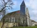
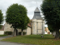
(11) Go and admire Croisilles’ heritage:the Romanesque church. The building consists of a Romanesque nave without a transept, vaulted with barrel vaults, and lit by eight side windows adorned with stained-glass panes.
In the church square stands a beautiful cross carved from ‘liais’ stone – a hard limestone with a very fine grain – three metres high, with rounded, sculpted arms. This cross is listed as a French Historic Monument.
Next to it stands the former seigneurial farmhouse (this is private property; please do not enter). It was connected directly to the church by a small tower with a vaulted room, opening directly onto the sacristy, which houses a fine Renaissance stone fireplace, known as a ‘chauffoir’, which allowed the lord of the manor’s family to attend services in winter and to warm the nave slightly.

Always be cautious and plan ahead when you're outdoors. Visorando and the author of this route cannot be held responsible for any accidents occurring on this route.

The GR® and PR® markings are the intellectual property of the Fédération Française de Randonnée Pédestre.

Reviews and comments

4 / 5
Based on 4 reviews

Reliability of the description
4 / 5
Ease of following the route
4.5 / 5
Route interest
3.5 / 5
Godaces et Sentiers
Godaces et Sentiers

Overall rating : 5 / 5

Date of your route : Dec 31, 2025
Reliability of the description : ★★★★★ Very good
Ease of following the route : ★★★★★ Very good
Route interest : ★★★★★ Very good
Very busy route : Yes

A very pleasant hike in the winter sunshine.
The explanations are clear. I'll be hiking with my group in January and will extend the hike to the small lake at Bréchamps.
Thank you. Godasses et Sentiers.

Machine-translated

farrolulu
farrolulu

Overall rating : 3.3 / 5

Date of your route : Mar 11, 2024
Reliability of the description : ★★★☆☆ Average
Ease of following the route : ★★★★☆ Good
Route interest : ★★★☆☆ Average
Very busy route : Yes

The start of the walk is rather dull – too much flat terrain
Also, avoid this route after heavy rain – the River Maltorne (6) is difficult to cross
AND at point (7), it’s easier to say to turn right at the stop sign before the mill

Machine-translated

La Rando Crusiliaise

Thank you for your comment and for following our journey. It is true that when the Eure goes over its banks, as it has done recently, the Maltorne Bridge in Mormoulins – being very low – becomes impassable. I will add this point to the walk description.

Machine-translated

libel
libel

Overall rating : 3 / 5

Date of your route : Mar 05, 2024
Reliability of the description : ★★★☆☆ Average
Ease of following the route : ★★★★☆ Good
Route interest : ★★☆☆☆ Disappointing
Very busy route : No

Avoid this walk in very wet weather, as the paths are waterlogged and difficult to walk on. Take care before reaching Mormoulin: the Maltorne river spills onto the path and crossing it is quite dangerous (strong current)
A walk best enjoyed in fine weather

Machine-translated

ealet
ealet

Overall rating : 4.7 / 5

Date of your route : Feb 25, 2024
Reliability of the description : ★★★★★ Very good
Ease of following the route : ★★★★★ Very good
Route interest : ★★★★☆ Good
Very busy route : No

A pleasant route (only the road section from 7 to 8 is a bit of a slog); you get to see a variety of sights. Best avoided after heavy rain (some sections are very muddy – 2 and before 10)
Thanks to the author for sharing this.

Machine-translated

Other walks in the area

For more walks, use our search engine .

The GPS track and description are the property of this route's author. Please do not copy them without permission.