Country:
 City:
City:


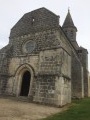
Park in Place Toussaint Raymond, in the village hall car park, between the town hall and the church.
(S) With your back to the car park, turn left onto Rue Jean-Jacques Rousseau, walk past the school and the war memorial, then turn left immediately onto Chemin du Maine Beaupart until you reach the Fork in the road.
(1) Keep to the left, ignoring Route de la Maine Beaupart and the path on the right shortly afterwards. Continue straight on between the fields for about 600 m until you reach a crossroads.
(2) Turn right and follow the track northwards towards the hamlet of La Grange. At the end, it joins a road. Leave the hamlet of La Grange on your left and continue to the T-junction, then turn left until you reach the Stop sign.
(3) At the crossroads, cross the Route de Châteauneuf with care and continue straight on along the Route de Chez Sorin. Pass under the power line and turn left onto the Route des Vallandreaux. After a few hundred metres, you’ll reach the hamlet of Les Vallandreaux. Continue to the start of a track, which is in a bend to the left of the road.
(4) Turn right onto this track and follow it past the maize silos. Cross a small wood and you’ll reach a T-junction. Turn left at the edge of the woodland and you’ll come to another T-junction.
(5) Turn left into the woodland. Continue along the edge of the woodland or between the fields, pass under a power line and reach the road at the entrance to the hamlet of La Bande de L’étang.
(6) Follow the road ahead, veering slightly to the right. Cross the D42 with care and continue straight on along a wide track. After a few dozen metres, turn right after the house, following the fence. Follow the track, passing close to an old wind turbine, and continue straight on to the end of the vineyards. Carry on until you reach the D22.
(7) Cross carefully and take Rue des Hauts de Pondeville opposite. Follow this road, ignoring the roads and paths on the right, to go round the hamlets of Chez Magniez and then Pondeville, rejoining the D22. Turn left, follow the D22 for about 250 m until you reach the first path on the right.
(8) Follow this for about 1.5 km. It winds its way through the fields; after a bend to the left and then to the right, it approaches the Ruisseau du Pérat (on your right), then reaches a T-junction.
(9) Turn 90° to the right, cross the stream and, at another left-hand bend, continue uphill for about 100 m until you find a grassy track on the right. You only see it at the last moment; it’s between the crops but is very clearly visible.
(10) Follow this path straight on until you reach a road.
(11) Turn left, follow the road, ignoring any side roads on the right. Head towards the church and turn left to return to Place Toussaint Raymond and the village hall car park (S/E).

 Visorando Member

 Tourist office
 Easy
Easy  Local authority