Circular walk starting from the Col de Leyrisse

A pleasant walk, mostly through the commune of Champis with a short detour into Alboussière. Very pleasant little paths.
Take great care at the several crossings or sections walking alongside the Departmental Road and the small tarmac roads connecting to the footpaths.

Details

46400734
Creation:
Last update:
Last review:
  • Walking
    Activity: Walking
  • ↔
    Distance: 6.01 mi
  • ◔
    Average duration: 3h 20 
  • ▲
    Difficulty: Moderate

  • ⚐
    Back to start: Yes
  • ↗
    Ascent: + 653 ft
  • ↘
    Descent: - 663 ft

  • ▲
    Highest point: 2,057 ft
  • ▼
    Lowest point: 1,470 ft

Description of the walk

Park in the small car park at the Col de Leyrisse, at the junction of the D533 and the D14.

(S/E) Cross the D533 – be careful as it is a very busy road – and take the Chemin du Bâtiment opposite (to the west), following theGR®420(red and white markings) to the house at Rosières. Walk past it; immediately afterwards, you’ll find a path leading downhill which joins the Chemin du Pin de Barjac.

(1) Turn right onto this path; you’ll come close to the D533 and take the steps on the left to reach the bridge over the Duzon. Cross the bridge, then take the Chemin du Vivier straight ahead. Take great care as there is heavy traffic; about a hundred metres further on, you’ll come to a crossroads.

(2) Leave theGR®420here and turn right onto the gently ascending track. Pass the sewage treatment plant and then the recycling centre to reach a small tarmac road.

(3) Take the path opposite, enter a small wood and then follow a fence. You’ll come to a small road; follow it straight ahead to reach the crossroads in the hamlet of Le Bourg.

(4) Turn right, pass through the hamlet and continue along the footpath. At the crossroads, keep left and walk almost level to reach the Mégalithes crossroads.

(5) Turn right onto the path leading downhill to the D219. Cross the road carefully and take the Chemin de Vinard opposite, marked in white and yellow, before entering the hamlet of Vinard.

(6) Take the path on the left, go through the first gate, then pass under a disused shed and keep to the path on the left at all times; do not head down towards the meadows. Go through several movable gates, taking care to close them properly. After passing under a wire fence, cross the meadow to rejoin the white and yellow markings opposite and follow them, keeping to the left at all times. Pass through a second gate to reach the hamlet of Garnier.

(7) Turn left onto Rue de l’Église until you reach the D219. Follow it to the right, heading north, for a few hundred metres. Take great care with traffic before reaching and passing the house at Rocoule.

(8) Take a track to the right, then immediately left, passing beneath the Champis Garnier cemetery to reach the D269. Follow it to the right, taking great care with traffic, until you reach the junction after the bridge over Le Duzon.

(9) Turn right onto Chemin de La Feyratière, a small tarmac road with a steep climb. Walk to the house at La Feyratière and continue along the path that follows. Walk along the edge of woods and fields, passing the stud farm, to reach the crossroads in the hamlet of Antoulin.

(10) Walk straight through the hamlet, rejoin theGR®420, and after the last house on the right, take the dirt track and follow the red and white markings. Walk past the Fringuet sheepfold before reaching the Col de Leyrisse car park (S/E).


Waypoints

  1. S/E : mi 0 - alt. 1,923 ft - Car park at the - Col de Leyrisse (587m)
  2. 1 : mi 0.78 - alt. 1,791 ft - Chemin Pin de Barjac junction
  3. 2 : mi 1.25 - alt. 1,716 ft - End of the GR
  4. 3 : mi 1.64 - alt. 1,768 ft - Junction on a tarmac road
  5. 4 : mi 1.9 - alt. 1,778 ft - Crossroads towards Le Bourg
  6. 5 : mi 2.5 - alt. 1,808 ft - Megaliths
  7. 6 : mi 2.87 - alt. 1,644 ft - Vinard
  8. 7 : mi 3.35 - alt. 1,634 ft - Garnier
  9. 8 : mi 3.65 - alt. 1,627 ft - Crossroads towards Rocoule
  10. 9 : mi 4.25 - alt. 1,490 ft - Bridge over the - Duzon (rivière)
  11. 10 : mi 5.09 - alt. 1,814 ft - Antoulin
  12. S/E : mi 6.01 - alt. 1,923 ft - Car park at the - Col de Leyrisse (587m)

Notes

Take care when crossing or walking alongside the departmental road. There are a few short stretches of tarmac road where the paths join.

Worth a visit

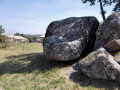
(5) Megaliths: take a moment here to read the information boards about these megaliths.

Always be cautious and plan ahead when you're outdoors. Visorando and the author of this route cannot be held responsible for any accidents occurring on this route.

The GR® and PR® markings are the intellectual property of the Fédération Française de Randonnée Pédestre.

Reviews and comments

3.9 / 5
Based on 4 reviews

Reliability of the description
3.3 / 5
Ease of following the route
3.8 / 5
Route interest
4.5 / 5
Danielle / Emmanuel / Shakti

Overall rating : 4.3 / 5

Date of your route : Mar 18, 2026
Reliability of the description : ★★★★☆ Good
Ease of following the route : ★★★★☆ Good
Route interest : ★★★★★ Very good
Very busy route : No

The sun was shining. A magnificent view of the Chemin des Rosières right from the start of the walk.
A lovely walk along varied paths and a few quiet country lanes.
In Vinars, the signposting is clearly visible at the entrance. No need to walk through the village.
A walk through woods, meadows and lush countryside. We’ll be back, adding a detour to the megaliths.
Thanks to the author.

Machine-translated

User 10823815

Overall rating : 2.7 / 5

Date of your route : Feb 22, 2026
Reliability of the description : ★★★☆☆ Average
Ease of following the route : ★★☆☆☆ Disappointing
Route interest : ★★★☆☆ Average
Very busy route : No

Nice hike but no signposts!

Machine-translated

alienoralienor
alienoralienor

Overall rating : 4 / 5

Date of your route : May 09, 2025
Reliability of the description : ★★★☆☆ Average
Ease of following the route : ★★★★☆ Good
Route interest : ★★★★★ Very good
Very busy route : No

This is a lovely walk that alternates between woodland, the edges of fields and a small village, along little-used paths that are truly charming at the start of May. We’re both keen walkers and we completed it in just under 3 hours
.

Machine-translated

VisoJPP
VisoJPP

Overall rating : 5 / 5

Date of your route : May 05, 2024
Reliability of the description : Not used / Not applicable
Ease of following the route : ★★★★★ Very good
Route interest : ★★★★★ Very good
Very busy route : No

A lovely walk!
Varied scenery, flower-filled meadows, tree-lined paths, small shaded trails, passing through pretty little hamlets with mostly unobstructed views. A really lovely walk!

Machine-translated

Other walks in the area

For more walks, use our search engine .

The GPS track and description are the property of this route's author. Please do not copy them without permission.