Park in the car park at the foot of the tower.
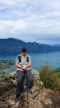
(S/E) Head to the base of the tower via the grassy path and then the steps to enjoy the view. Go back down the steps and go round the complex to the south (towards Grenoble) to reach the tarmac road heading due south before turning back towards the north-east (essentially a U-turn). You’ll arrive at a crossroads.
(1) Turn right and head towards the clearly visible church of Saint-Maximin, either via the road (see the route) or by skirting the cemetery.
(2) Leave the church on your right and continue slightly uphill, then pass between two houses on the right to reach the small tarmac road that runs beneath the church. Follow this road uphill alongside the stream.
(3) After crossing over the stream, head up to the right, following the stream, and join a path that climbs steeply and straight up to the hamlet of Varanger, where you’ll reach a tarmac road.
(4) Turn left onto this path, pass the next hamlet, Les Bruns, and continue in the same direction. The path climbs gently, then becomes a wide track that passes under a water intake, levels out again, and descends until it joins a small tarmac road at the hamlet of Le Couvat.
(5) Turn left then right and continue in the same direction (north-east). This road becomes a track, which climbs quite steeply to reach a Fork in the road (you will pass a group of large houses and barns on your left, marked ‘private property’, just before this).
(6) Turn left, heading north-east. The track climbs slightly and, 200 m further on, a path descends to the left towards the hamlet of Le Puillet.
(7) Follow this path, which branches off to the left and descends steadily to the hamlet of Les Bretonnières, where you join the D9 (which can take you directly back to the Church of Saint-Maximin).
(8) Follow this road to the left (south-west) to the hamlet of Les Ripellets, where the D9 crosses over a stream.
(9) Look for a flight of steps on the left-hand side of the road with hiking signs and head down to the right along the tarmac road that runs alongside the stream. It very quickly becomes a track and then a path overlooking the stream. Continue down to a junction with a path coming from the right (from Les Bretonnières, in fact).
(10) Turn left at the junction to use the footbridge, which is clearly visible on the descent. Climb up to the other bank, following the yellow markings (do not cross via thesecond footbridge further up or the small staircase visible there), but follow this other stream, keeping it on your right. Continue straight on towards the Tour d’Avalon, joining the junction of the circular road.
(1) Continue straight on to reach the Tower of Avalon (clearly visible) by following the route back in the opposite direction to the outward journey (or via the hamlet below the tower, as you prefer) (S/E).