Country:

 City:
City:



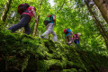
(Start/Finish) The route starts at the Bad Peterstal outdoor swimming pool, at the edge of the woodland above the car park. From there, the path leads into the woodland; it curves to the right, we cross the road ‘Am Sportplatz’ and continue through the woodland.
(1) Over the first three kilometres of the Himmelssteig, we immerse ourselves in the forests of the Rench Valley. On warm days, many will be grateful for this, as there is a climb of more than 200 metres to tackle, from 433 to 657 metres. Yet the diverse natural surroundings make the uphill walk a pleasure: We pass through beech and chestnut woods, spruce and fir forests – sometimes open, sometimes densely forested like something out of a fairy tale – with lush ferns, woodland shrubs and berries lining the path from time to time. The paths are sometimes mossy or grassy, sometimes root-strewn or rocky. A lovely start to the Himmelssteig, along whose 10.6 kilometres we’ll experience plenty more variety.
Anyone who gets out of breath quickly will be delighted to find the first ‘Himmelsliege’ after a kilometre, which we reach after a left-hand bend. We then turn right and, as we continue our walk, catch glimpses of the steep Black Forest mountains. After a right-hand bend, the climb is over.
(2) After a few metres along the forest track, a path branches off to the right onto a meadow. Here, the most sweeping view awaits us: westwards towards the mountains and valleys of the Rench Valley. Highlight: the 22.5-metre-long ‘Himmelsbank’.
(3) The second stage is a leisurely walk, with the Holchen waterfall at 572 metres as our destination. We leave the Himmelsbank behind; for a short while, the Himmelssteig leads uphill alongside an animal enclosure. We then follow the meadow path, bypassing the few houses up here on the Überskopf.
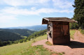
(4) At the edge of the forest, the next cosy spot beckons: the Himmelsbar, complete with a ‘Himmelsliege’ (heavenly lounger) and seating area. Gently rolling wooded hills stretch out before us once more. It is quiet here.
(5) We cross the road and continue along a root-strewn path. Soon we read on a signpost: ‘Holchen Waterfall 2 km’. Shortly afterwards: the curtain rises – a view straight up into the sky. Along meadow paths, mostly skirting the edge of the forest, we enjoy about a kilometre of Black Forest idyll; it’s secluded here, with just two farms operating at the end of the valley. We reach a wider forest track and walk around the head of the valley.
(6) Suddenly, a very narrow path veers off to the right: we walk downhill over springy forest floor, through a small beech wood, and pass the Paradies Rock – or climb it briefly. Behind it, we turn left and then curve to the right.
(7) The sound of rushing water heralds the Holchen Waterfall. In the middle of the forest, it plunges down two tiers for about eight metres. We’re halfway there; we’ve covered 5.3 kilometres. Drinks are available for a small fee by the stream we cross. However, anyone wishing to take a break and enjoy the view will have to walk another kilometre to the Himmelsfelsen.
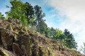
(8) The climb up to the Himmelsfelsen, which we begin by turning left, is no mean feat, however: 1.2 kilometres and a 100-metre ascent lie ahead. The only thing that makes it bearable are the wonderfully soft forest paths, which zigzag through the sparse mixed mountain woodland. Suddenly, on the right-hand side, a barren rock face: the Himmelsfelsen towers above us. One final hairpin bend through the woods, then here too a rest area and a ‘Himmelsliege’ (sky lounger) invite us to stop for a snack. Our gaze wanders past a farm to the opposite side of the small Holchentals valley, where we were only recently.
(9) An adventurous path now winds its way further uphill amidst the rocks, joining a forest track which we follow to the right. Shortly afterwards, we feel like scouts again. Turning right, we simply head straight through the forest. Little by little, we lose altitude. Eventually, we reach a ‘Himmelsliege’ above Palmspring, once a mountain inn, now a group accommodation. Sheltered by the forest canopy, it’s a lovely spot to rest. We then leave Palmspring to our left and walk across meadows back into the forest.
(10) From the little bench, our gaze wanders once more over the Black Forest mountains. Then, mostly flanked by dense ferns, we walk down a forest path to the left towards a forest track. There, we look out for the ‘Himmelssteig’ signpost on the right-hand side of the path. Via wooden steps, it leads us onto a wild and romantic forest path through a secluded mountain stream valley. Here, the water rushes and splashes; the ferns and bushes are a rich green, and the rocks are moss-covered. We continue through sparse woodland, over a mountain ridge, then criss-crossing down a mossy path. We pass a timber storage area on the forest track and cross a small road. There, we join a root-strewn forest path that takes us about one kilometre uphill and downhill through a fir forest.
(11) The leisurely finale to the Himmelssteig is well deserved. We stroll at a leisurely pace for around 1.8 kilometres along the Freiersbach Valley on forest and meadow paths. Every now and then we catch a glimpse of the first houses in the village, and we’re treated to views of the valley from time to time. Here, the Black Forest slopes squeeze together in a very confined space. Just before the final stretch of meadow path, a ‘Himmelsbank’ with a rest area and drinking fountain invites us to take one last break. Towards evening, it’s still lovely to enjoy the sun here.
(Start/Finish) The houses of Bad Peterstal come into view, along with the outdoor swimming pool and the car park. We cross a road and walk a few more metres downhill through the woods to the starting point.

 Visorando Member
 Moderate
 Easy
Easy 
 Tourist office