Country:

 City:
City:


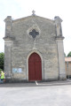
The car park is situated next to Saint-Seurin Church (there are two options: in front of the gate on the west side, behind the nave on the east side, or even on the south side of the church). Alternatively, you can park at the Lamourous hermitage.
(S/E) Leave Saint-Seurin Church by following the D211 road northwards (at the junction next to the church, turn left). Follow this road (Allée des Bruyères) carefully for about 300 metres until you reach Peyquem on the right-hand side of the road.
(1) Turn left onto the farm track heading north (unpaved track). After 150 metres, the track turns left. Shortly afterwards, leave the main track and continue straight on towards the woodland.
(2) At the edge of the woodland, turn right and follow the track that runs alongside the woodland on your left. A little further on, on the right and slightly set back, is the hamlet of Camparian. Shortly afterwards, after about sixty metres, the track turns left and enters the woodland. At the crossroads immediately after, turn right and follow the track heading north.
(3) At the next crossroads, turn left and follow the path which crosses the woods heading south-west. Initially, the path runs alongside a seasonal stream.
(4) When you reach the edge of the woodland, at a crossroads, turn left.
(5) At the next crossroads, turn left again onto the path, which now heads north-east.
(6) Seven to eight hundred metres further on, at the crossroads, take the path on the left which heads north-east. Follow it straight on to the edge of the woodland.
(7) As you emerge from the woods, turn right onto the path that runs alongside a vineyard plot heading south. About a hundred metres further on, there is a tree marking a crossroads. Continue straight on until you reach the Allée de l’Église Saint-Seurin (road). Turn left and follow the road carefully as far as the church, which marks the end of the route (S/E).
 Visorando Member

 Difficult